
-
 8150 Hits
-
 80.49% Score
-
 12 Votes
|
|
Mountain/Rock |
|---|---|
|
|
49.90917°N / 126.47833°W |
|
|
Hiking, Mountaineering, Scrambling |
|
|
Spring, Summer, Fall |
|
|
5338 ft / 1627 m |
|
|
Overview
Thumb Peak is the most northerly of the significant summits in the Alava Bate Sanctuary, a little known and even less visited alpine paradise in west central Vancouver Island, British Columbia.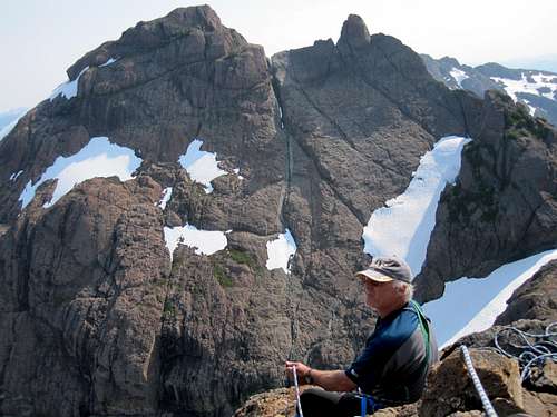 Thumb Peak west aspect Thumb Peak west aspect |
Nowadays the approach from the southeast via the Conuma River to the Shangri La basin is the generally accepted best and fastest approach and, since Thumb lies a scant 450 metres above the basin, it is usually the first peak that first time visitors climb.
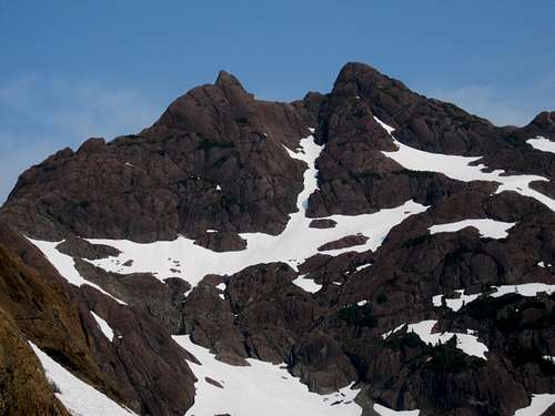
Thumb Peak east aspect
The mountain is found in the northeast sector of the Sanctuary, above and to the northwest of Shangri La Lake and is most conveniently climbed from there.
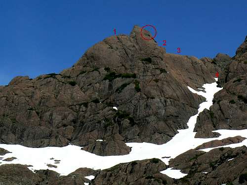
The usual Class 2/3 route to the summit is via the col between it and Tlupana Ridge to the east and up the friendly east ridge from there. Easy snow slopes and slabs of red/brown abrasive karmutzen pillow lava are all the climber need contend with, although there are plenty of options for steeper and more difficult diversions if so desired.
Thumb Peak NE aspect
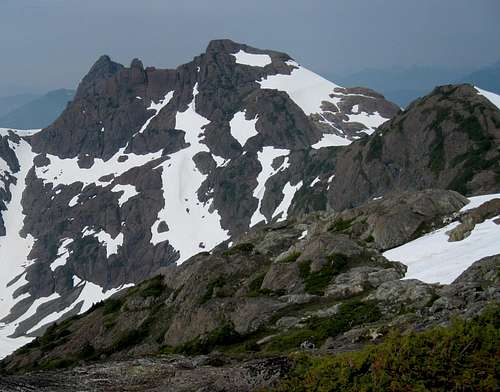
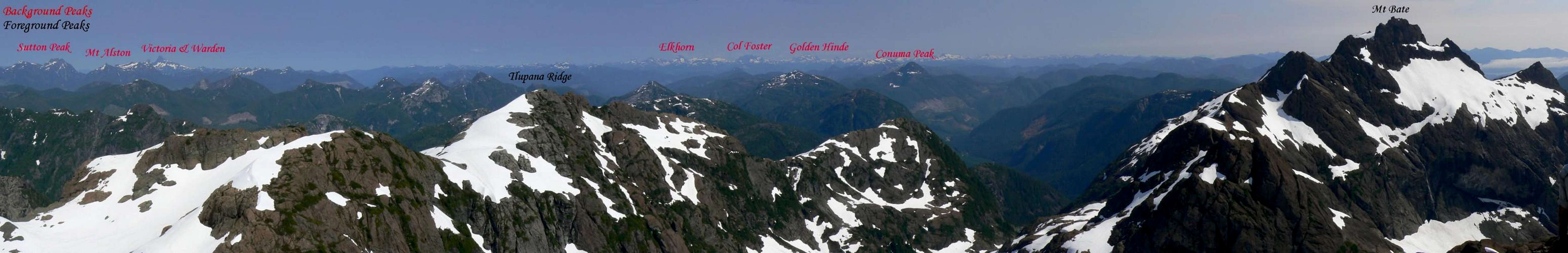
As with every high point in the Sanctuary, summit views both within the area and beyond to the Island ranges are stunning.
Thumb Peak is named for the distinctive gendarme on its south ridge. In fact when viewed from the summit of Thumb Peak, buttresses falling off the Thumb to the northwest look like curled fingers and the whole was known for some time as the “Hitchhiker”.
The Thumb gendarme is also climbed but from the south via the same approach as Mt Grattan. The Thumb is a far more difficult proposition than the main summit involving high exposure and 5th Class climbing. (See below).
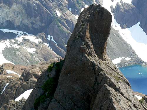
"The Thumb"
Fifteen years after each was first climbed separately, The Thumb and Thumb Peak have recently been enchained for the first time.
Thumb Peak FRA: R Eppler, P Erickson, K Erickson, J Henderson, R Macdonald, July 1995 from Shangri La
The Thumb FRA: R Eppler, P Erickson, K Erickson, J Henderson, R Macdonald, July 1995 from Shangri La
The Thumb to Thumb Peak (south to north) Traverse FRA: M Allingham and K Hoover August 6, 2010
Getting There
Vancouver Island can be reached directly by air from Toronto, Vancouver, Seattle, Calgary, Edmonton and recently San Francisco to Victoria and by ferry from Port Angeles to Victoria on The Coho and on BC Ferries from Vancouver to Victoria or Nanaimo. Public transport on the Island is notoriously poor and anyone arriving by air would be advised to rent a car.Access to the main points of entry to the Sanctuary involves logging road travel but on main lines. A 2WD vehicle would normally be expected to suffice.
Thumb Peak is climbed almost exclusively from the Shangri La basin via the Conuma River approach and only this will be described here. Anyone wanting to approach from the Perry River via Peter Lake is referred to the parent area page.
From any point on southern Vancouver Island, drive north on the Island Highway 19 to Campbell River. From Campbell River take highway 28 west through Strathcona Provincial Park and onwards to Gold River. Just before entering the town of Gold River, watch for a right turn signed for Tahsis. It’s immediately after the tourist information office. Proceed 2 km on this road and across the bridge over the Gold River. Here the road splits. Right to Woss and left to Tahsis. Note this point on your odometer and turn left onto “Head Bay Road”. The pavement ends almost immediately, but this is good sealed or gravel road.
Drive about 27 km from the Gold River bridge and find Conuma Main on the right just after crossing the Conuma River. Drive this good main line about 11.5 km, passing the C15 access for Conuma Peak after 3.5 km and park at about N49 52.403 W126 24.954. The route to Shangri La Lake via the Conuma River approach starts here. Mt Bate towers above you to the northwest.
Approach
The approach described below involves heavy bush and difficult travel. These difficulties are in no small measure responsible for the few visitors that the Sanctuary has seen over the years.From the start point travel west and then follow the river north up the steep sided canyon. The route has been recently (July 2010) flagged. Beware of a dangerous river crossing at N49 52.753 W126 26.725. A ramp at N49 53.766 W126 27.450 is used to bypass a waterfall about half way up the canyon. Travel time to Shangri La 6-8 hours.
The Airborne Alternative
Over the years a number of visitors have accessed the area via helicopter. The local ecosystems in the Sanctuary are delicate and fragile and, in this case, an air assist might just be the least invasive way to reach and stay there. See the “Camping” section below.Summit Route
From the Shangri La basin walk north up snow or scree slopes to the Thumb Peak/Tlupana Ridge col at N49 54.574 W126 28.356 and about 1,450 metres elevation. Turn left (west).Continue west up snow and lava slabs to about N49 54.607 W126 28.692, turn south on to the summit ridge and along to the top from there.
There is a cairn and a register to sign but nothing in the way of a monument. None of Vancouver Island’s surveyors ever came this way.
Descend the way you came up.
 Climbing Thumb Peak Climbing Thumb Peak |  Thumb Peak summit Thumb Peak summit |  Descending Thumb Peak Descending Thumb Peak |
Route summary from Shangri La:
Distance: ~ 3.0 km
Net elevation gain: ~ 450 metres
Total elevation gain: ~ 500 metres
Approximate time: ~ 2-3 hours return
As always a Garmin/Mapsource tracklog is available for the approach and climbing route on Thumb Peak. Just ask for it via an email or PM.
The Thumb
Approach from Shangri La Lake by climbing due west up the steep snow couloir on the south flanks of Thumb Peak. Climbing The Thumb I Climbing The Thumb I |  Climbing The Thumb II Climbing The Thumb II |  Climbing The Thumb III Climbing The Thumb III |
The Thumb to Thumb Enchainment
Mort Allingham and Karen Hoover describe their first ascent of this route.“One rope rappel to a notch between the Thumb and the serrated section of the Thumb to Thumb ridge.
Short pitch up and down serrations to a sling belay on the last spike.
Down climb to the base of the serrations. 45 Metre roped scramble along the ridge with a couple of sling runners.
Belay at a large block in a large notch of an eroded dyke.
Ridge then blocked by near vertical wall. Down climb/rappel 30 metre gulley towards the east. Loose rock, not enjoyable.
Climb out of gulley and up Thumb Peak in two roped pitches and a scramble up east side of peak.
All climbing mid 5th Class or less.”
Mort and Karen’s route is illustrated in the following sequence taken from Shangri La. The “vertical wall” that confronted them doesn’t show from this aspect but is clearly evident from the west.
Thumb to Thumb Peak Enchainment
 1 1 |  2 2 |  3 3 |  4 4 |
Red Tape/Safety Considerations
Thumb Peak and the Alava Bate Sanctuary could not be more removed from the need to consider red tape. Almost no-one goes there and few outside the climbing fraternity know of its existence. With this caveat, therefore, comes the need to consider safety.Unless you’re supremely confident in your abilities to look after yourself come what may, I would consider a satellite phone mandatory for trips into this wild and remote area. Make sure that you have left a detailed trip plan with someone responsible. The appropriate SAR agency will respond in an emergency but it is up to you to have the mechanism in place that will initiate the call-out process if it becomes necessary. Know your exact coordinates at all times. Consider personal limited range radios for communication within your group.
Camping
Most visitors will camp on the extensive gravel flats at the outlet end of Shangri La Lake. These, and anywhere else in the Sanctuary, are areas which are delicate in the extreme. Fires are absolutely out of the question – there’s no wood anyway. Tread carefully amongst the acres of flowers. Try to keep your footprint as low as possible.Low to non-existent soil levels mean that disposal of human waste is a super critical issue. Above all other reasons (e.g. to avoid the difficult approach conditions) flying out waste and garbage is a strong argument in favour of keeping the area pristine by means of a helicopter assist and several parties have done just that.
Weather
Nearest point current conditions and forecast.East
West
Additional Information/Suggested Reading
As in the case of many objectives on Vancouver Island, Lindsay Elms, our local guru on all things obscure and hard-to-get-to, has written an excellent historical and geographical perspective of The Sanctuary, including Thumb Peak, on his Beyond Nootka website. Don’t fail to visit this site before your trip.Island Alpine – A Guide to The Mountains of Strathcona Park and Vancouver Island, Philip Stone, Wild Isle Publications, 2003, ISBN 0-9680766-5-3 and/or visit Island Alpine Climbing Guide
An excellent guide to the back roads of Vancouver Island is Backroad Mapbook. Volume III: Vancouver Island
Map Issues
The map for this trip is the government 1:50 000 topographical map sheet 92-E/16, “Gold River”. Advance copies can be ordered on-line at this link. Copies are usually readily available in good bookstores and outdoor stores throughout the Island.Be aware that many features of the Sanctuary are mislabeled on the government map. Mt Alava is placed where the lower south satellite is located and Mt Bate is, in reality, located some 500 metres to the northeast of its map label.
Sitting on the summit of Thumb Peak my Garmin GPS map showed me to be at 1,585 metres elevation and about 50 metres SW of the summit. The true elevation is 1,627 metres, in perfect agreement with the two altimeters I carried with me. My in situ co-ordinates for the summit later agreed with those from Google Maps.
Thumb Peak Summit Panorama
  |