
|
|
Route |
|---|---|
|
|
40.52200°N / 108.381°W |
|
|
Hike with minor scrambling (no trail) |
|
|
Half a day |
|
|
Class 2 |
|
|
Approach
From Maybell and Highway 40, turn onto State Highway 318 and follow it Northwest along the Yampa River. After a short distance, pass through the tiny community of Sunbeam. After a few miles, turn west (left) on County Road 10 (gravel) and follow it west. Follow this road all the way to the northern terminus of the Cross Mountain Ridge. Park on County Road 10 at an overgrown road on the left that is marked as being closed to vehicles.
There are alternate routes to the trailhead. From Sunbeam (see above, you can continue along State Highway 318 to County Road 21.5 on the left. This road can be followed to County Road 10 not far east of the trailhead. From there, drive west to the trailhead (see above).
Another route is to the Deerlodge Park Road. From Mile Marker 44 on Highway 40, west of Maybell or east of Dinosaur, turn north on the road marked for Deerlodge Park. Follow this paved road to County Road 25 on the right (north). Turn north on the county road (gravel) and follow it all the way to County Road 10 along the Snake River. Turn right and follow County Road 10 to the northern terminus of the north ridge of Cross Mountain (see above).
 |
Route Description
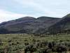
From the car-park, follow the old, overgrown, and blocked-off road south and towards the north ridge. When you are near the ridge, simply climb up to it, and follow the ridge south. There is not any constructed trail, but game trails are very plentiful and it is evident that the ridge is well used by bighorn sheep, deer, and elk very frequently. The ridge is steep and it seems that there are fewer trees on the west side of the ridge. There are also a few areas with minor scrambling up rock-bands. Make sure to keep an eye out for fossils as there are many, some of them are 3-4 inches in diameter. There are a few ups and downs before reaching the northern-most sub peak at 6891 feet. After this point, the ridge becomes more open and gentle. After passing the next sub-peak, you will noticed that the ridge has been burned years ago and is very open. The grassy ridge continues for eight miles one way, but we didn't go any further than the northern summits. Just follow the ridge for as much distance as you have time available. The views are spectacular in all directions and save a few ranches and roads visible, there are few signs of civilization, though Maybell (population 30) should be visible from parts of the ridge. The ridge appears to be fairly gentle and it would make a spectacular backpacking trip by following the ridge all the way to the north rim of the Cross Mountain Gorge. The north rim is even higher than the south rim (see the photographs), and should be very spectacular. This would be a very long one day hike, but you could camp on the ridge and do the hike in two days. In late April or early May, there should be snowbanks around for water and this would be the recommended season to do a two-day trip.


Essential Gear
A good pair of boots is needed.