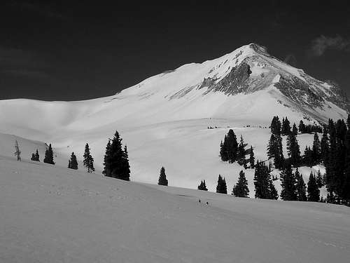
Sunshine Mountain
![Sunshine Mountain]() Mike and Sunshine Mountain.
Mike and Sunshine Mountain.After a fairly miserable day up on
Phoenix Peak with weather that could only be described as mischievous and at times, downright barbarous, we parted ways with Ken Nolan (who had plans to conquer a few 12ers) and the rest of us drove down and around from Creede over to Lake City to hike up a few ranked mountains,
Point 13,093, Sunshine Mountain and Dolly Varden, a ranked high 12er that occupies a low spot along the same docile ridge.
We had to sleep at the Matterhorn Creek Trailhead, which also serves as the launching spot for Wetterhorn Peak, Matterhorn Peak and Broken Hill. Past this fork, the North Henson Creek Road is pretty much closed due to four avalanche debris paths. One of these paths is quite large and the runoff of another cuts a deep trench through the road. Slightly before Mary Alice Creek, the snow becomes very uniform and consistent on the road. It’s not like an extra four miles RT is going to make much of a difference anyway.
Mike (
Chicagotransplant), Dominic &
Sarah Thompson and myself took our first real break at Hensons' end. A quick look at the topo, some water and a moment’s respite from the ‘Niagra’ sweat of having set a good pace was nice to have. Looking south from the end of the road, an enticing notch up on the ridge, barely visible through the trees showed a possible route to attain the ridge but it would mean switch backing up steep snow via a shallow inset gully that we really didn’t feel like enduring. The map showed some gentler and thus more forgiving terrain to be up further in the basin. So we set off chasing Mike through the forest on good early morning snow. The morning was brilliantly blue and clear, relatively calm (at least in the trees) and the snowy terrain was new to all of us. The sense of discovery was refreshingly high. It’s funny how when you replace said conditions with snow, high winds, blizzard and cold temperatures, that sense of discovery either turns into one of questioning trepidation or obdurate stubbornness; I suppose it depends on one’s personal fortitude.
We traversed a small cliff band for perhaps 200 feet until Mike indeed found a weakness in the upper flanks. We switch backed our way up moderate snow through what turned out to be nothing more than a shallow cut in the rock. At the top of this intermediary precipice, we took a break in a clearing. The views of Wetterhorn and Uncompahgre Peak were breathtaking. I’d never seen these particular mountains from this vantage and I kept thinking they looked a lot like broken teeth along a massive white chainsaw. Once refueled, I lead the rest of the way up to a last standing patch of Evergreens at the top of treeline. The elevation if I remember correctly was somewhere around 12,000ft. This is rather high for treeline but it is after all, an arbitrary mark. Dominic spotted an animal off in the distance near the bottom the ridge. Though at such a distance, it was nigh of impossible to accurately guess what it was. But we threw out fox, coyote and even lynx as suggestions. Once again, Mike picked up the lead slicing through perfect guache. There’s something about setting down a singular track through virgin snow that is aesthetically pleasing; it’s very focusing in a singular way.
![A solitary line]()
Sunshine Mountain at 13,321ft is Colorado’s 375th highest. Sunshine turned out to be a gentle mountain. From the lower plateau area between treeline and the upper ridge, it's all easy
class-1 and maybe class-2. Once we crested the actual ridge, which seemed to be nothing more than an arm of a hibernating giant, it was an easy walk-up to Sunshine’s summit. Looking west, the conical head of 13,093 would prove to be at least mildly interesting. Sunshine’s east face was something else; vertical palisades of rock with a decent drop off. I’ve noticed this tends to be a common trait among peaks in the San Juan Mountain Range. Some notables being Matterhorn Peak, Handies Peak, Vestal Peak, Pt. 13,093, Wildhorse Peak, Redcloud and Windom Peak . Blackwall and Funky Peak looked like solid exceptions.
Once on Sunshine’s summit, we were the first ones to sign the CMC summit register since August of 2007 proving that we were indeed off the beaten path. I have nothing against repeating old mountains, it’s always nice to come back to a familiar area, say hi and tread old hat. But it’s visiting the peaks and mountains that we know nothing about that reminds us why Colorado is so special and enduring. The vista south and west towards Cinnamon Pass, Handies Peak and American Basin I would imagine under summer conditions would be magnificent but now, in late May, the views were magnificently ‘Februaryish’.
The wind picked up a little more (not that it ever stopped blowing to begin with) and we took this as a silent cue to move on to our next destination, Point 13,093.
Point 13,093
![Stoic and White]() Stoic, venerable & overlooked.
Stoic, venerable & overlooked.
Like fleas quickly moving along the arm of a giant Yeti, we reached our snowshoe stash. Mike and I lead the easy traverse across to the proper saddle (a bit hard to pick out). The snow was no more than 5-7” deep with the expected softer pockets and wind scoured abrasions. Once near the base of 13,093, Sarah and Dominic lead the way up steeper terrain. The summit was truly a small place and actually Gemini in nature. A prominent cairn marked the true summit. Again, a CMC register was also located here albeit with more names in the register. This was a good thing since the sister half was corniced heavily.
Point 13,093 as Mike and I both agreed is a mountain of many different faces. From N. Henson Creek Road, it looks fierce and challenging, almost as if it’s leering at you like Old Man Aqualung. From the saddle and Sunshine’s summit, it changes faces to a broad, mellow mountain with twin summits barely perceivable to be separate. Oft, while walking towards 13,093, I kept thinking how closely it looked like
Square Top. At the summit, one is much loftier then what it appears from the ridge. And from the west and north, one can just barely see the start of teeth. This was a surprisingly enjoyable summit.
The descent off the mountain down to the saddle with Dolly Varden was probably the trickiest portion of the day. We followed Dominic down a rather steep ridge crest. Loose rocks and snow kept us on our toes. The drop to the north, though not severe was steep enough to make you think twice about stumbling. The wind was really howling at this point. Sarah and Mike could have yelled something at me and it would have been doubtful if I had heard anything. Dominic was too far ahead.
At the summit before the climb down, I had on a long sleeve shirt and a long sleeve
Capilene. Over that, I wore a
MH Alchemy Softshell and a
Marmot precip jacket, meant for rain and wet weather obviously but I found that it also serves pretty dam well as a wind blocker. It was just enough to keep warm on a sunny day. We all pretty much kept shedding layers and putting them back on all day.
Dolly Varden Mountain was nothing but a plateau, you could play a game of football up there. Fact from the summit of Pt. 13,093 it was rather hard to distinguish. Again, we stopped for a while to eat and plan on how we should navigate our way down back to the valley floor. A direct start was out because of some deep slopes and cornices above said slopes from Dolly Varden Mountain. The interior (head) of the valley was guarded by a waterfall, so we had to come up with something that included safe navigation on increasingly softer and potentially deep snow.
![From the North]() From the North at the end o' the day.
From the North at the end o' the day.
Sarah and I followed Dominic and Mike down the other side to a very obvious flat area. We ended up contouring around a mild bump to our left (northwest) and headed into the trees. Here, we explored into the trees for a short while sure the cliffs were just ahead. Mike confirmed this on a short scouting mission. Sarah and I could see a mild slope peeking through the trees to our immediate right. Heading back up into the valley for only a short distance, we came out on the beginnings of a cliff band that did indeed end at a navigational snow slope.
![At the end of the day...]() A long day coming to an end.
A long day coming to an end.
The waterfall that we wanted to avoid was further over to the right. Dominic and Sarah jumped down and foot-skied down into the trees. I took this opportunity and glissaded it. We waited for Mike. In the past 20 minutes from when we last saw the North Face of Pt. 13,093, it had experienced a wet slide! I found this a little aggravating since I’ve always wanted to witness one.
As it turned out, the trek out was actually straightforward and to be honest, a little mind-numbing. The snow was holding up and postholing was minimal, even without snowshoes. We found our old, melted-in tracks from the morning and made our way out back to the road. The road was posthole central and a sloppy mess. But to be honest, I was kind of expecting this, so no surprise there. After some beers and rest back at the cars, we immediately headed out for Poker Alice’s and planned the next day. Monday would be Mike’s 100th summit. I wouldn’t be joining them (sick & tired of the wind), but Dominic, Sarah and Mike headed for
“Sundog” on what would be a successful but windy day.
Comments
No comments posted yet.


