
-
 4475 Hits
-
 72.08% Score
-
 2 Votes
|
|
Route |
|---|---|
|
|
46.84890°N / 10.47210°E |
|
|
Hiking |
|
|
Spring, Summer, Fall, Winter |
|
|
Half a day |
|
|
Hike |
|
|
Overview
 On the Old Military Road On the Old Military Road |
The normal route to Piz Lad is one of the most popular hikes in the area of Reschensee / Lago di Resia. When started from Reschen village it covers a whooping 1400m of elevation. The route is sometimes steep but offers no real difficulties. However, since the lower 400m are hidden in the larch and pine forest which covers the east slopes of Piz Lad, you don't miss anything if you choose the trailhead at Reschner Alm / Malga di Resia, a mountain farm, located at roughly 2000m on the eastern slopes of the mountain.
The trail is well marked, a part runs on dirt and military roads. Views to the east and south are open. Halfway up from Reschner Alm the route splits into the Normal Route described here and the Grubenjoch Route, which climbs the mountain from its south ridge.
Getting There
 Alm Seßlat and Grüne Pleißen
The main page describes how you can reach the village of Reschen / Resia. From there proceed as follows:
- In the upper part of the village (direction Reschenpass) there is a marked road leading to the Schöneben Ski Lift.
- Follow this road to the western shore of the lake
- Pass the ski lift heading for the hamlet of Rojen
- After several switchbacks the road levels and here a sign directs you to the right to Reschner Alm.
- Follow the dirt road for some 5km. It is very narrow in several places.
Route Description
 Reschensee / Lago di Resia
- Start altitude: 2000m
- Summit altitude: 2808m
- Prevailing exposure: SE
- Type: Hike
- Protection: None
After parking your car at the small parking lot at Reschner Alm, proceed along the road through a gate (Sign: Piz Lad: 2h 20min). Follow the road for about 2km until a narrow path turns off to the left (sign). The path traverses a slope leading you back to Reschner Alm, which you'll reach about 100m higher. Now the path winds through the few remaining trees onto a lookout ledge.
From the ledge, from where you can see Piz Lad for the first time, the path turns westward, heading for a valley between Piz Lad and the long ridge of Grüne Pleißen. The valley is called Alm Seßlat and is used for cattle grazing in the summertime. In autumn, when the cattle have already left, you are bound to find Ibexes here.
 Reschensee Reschensee | 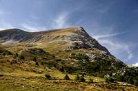 SE Face SE Face |
A short steep section leads you to an old military road, remainder of the times of WW II. The road touches a lookout hill with a cross before taking a long sweeping turn through Alm Seßlat. Reaching the Piz Lad SE-slopes it quickly ascends in switchbacks towards the fore summit, which carries the cross. The real summit is set back a little an can be reached by a stroll of some 200m from the foresummit.