
|
|
Route |
|---|---|
|
|
42.73635°N / 0.36080°E |
|
|
Mountaineering |
|
|
Spring |
|
|
Most of a day |
|
|
F (UIAA) |
|
|
Class 3 |
|
|
I |
|
|
Page optimized for a screen resolution of 1280 x 1024 pixels
Overview
This is the most common route to climb Lustou. Nice and easy, even with snow, as I describe it, is interesting but remains relatively affordable. The only obstacles are some aerial but feasibles passages in the edge and the slopes have moderate tilt angles. Despite the clouds and fog of the day, as can be seen in the photos, the environment I could see from time to time, is great.My overall impression is that it is a mountain that deserves more fame (although it may be better that way) and that its northwestern edge is an option to make the jump from ascents "for cows" to some dificult routes.
Technical sum:
- Elevation gain: About 1,650 meters.
- Minimum / Maximum Height: 1,380 m / 3,023 m
- Time: about 7 hours roundtrip, without counting stops.
- Difficulty: F +. Sharp passages and small climbings (I) on the ridge. With snow, tilt angles up to 40º.
- Done for the last time: June 9, 2008.
Itinerary:Bridge of Fredançon - Péguère's Ravine - point 1,944 - Hut of Thou - Lustou' Ridge - Lustou's Peak - return.
 map is taken from IGN TOP 25 Series, 1748-sheet ET "Néouvielle"
Getting There
From Tramezaïgues (see the Lustou page), take the road that leaves the village in front of city hall. After about 8 km, there is a parking space on the left of the road, with the bridge of Fredançon in the background. In the other side of it, there is a camping area among the pines. The passage of vehicles is banned from bridge... Time to walk!In the middle of winter the approach could be a problem because the road is not kept beyond Tramezaïgues. Its closure involves to walk up to 16 km in addition to the climbing.
Route Description
Cross the Bridge of Fredançon and take the track that, almost flat, goes to the southwest among the trees. Near of a cement bridge that cross Péguères’ Stream, take a clear path that goes to the left (NW) under the pines. A few meters after, the path reaches Péguères’ Stream, wades it and continues on the opposite bank, turning to the left (E). The path goes up parallel the watercouse and quite separate from it, through a wide strip of grass that cuts the forest. Bridge of Fredançon
 Through the forest
The path is easy to follow. Soon, trees are left behind and, in front of the small waterfall of the Piarre’s Stream, the path turns to the right (SE) following the slope. By reaching an elongated landing of meadow, some big cairns indicate where turn left (NE), wade the stream and go up the grassy hillside of the opposite shore.
 Waterfall in Piarre's Stream
 Steepy meadows in Thou
The path turns right (SE) to surround a modest promontory and reach the landing where the hut of Thou is. It is a small and coarse building, with a sleeping room for two persons, but if necessary some more can accommodate in the other room, where there is a table, benchs and a fireplace. From its door, we can look the valley under the clouds that hid the summits of the group of Mount Aret. Continue ascending a grassy slope with undulations and moderate inclination. The path is clear and marked with cairns. When I was, I found here the first fridge and fog.
 View from the hut iof Thou door
 Fog in Thou
When path and milestones were under the snow, I took the slope as reference and go up directly. Shortly after, the ridge appeared over me, with the Pass of Lustou, where the normal route passes, on my right. There is several gullies of moderate incline to reach the ridge above me. I chose one, with an incline well below 45º, and I went into it. To climb the stones between gullies is also easy but I prefer the snow.
 The pass of Lustou
 Reaching ridge of Lustou
On reaching the ridge, the clouds retreated enough to let me see a wonderful image of the Peak Guerreys. I also have a look at what I have climbed.
 Peak Guerreys
 A look back
I had reached the ridge, a little below the point 2,767 m high on the map. From there, the ridge is a blade of snow narrow but regular. Following a change of slope, the rock, snow and ice are mixed in the ridge and the climbing needs attention but continues to be easy. Between the fog, the summit appears.
 The ridge seen from point 2,767
 First sight of the summit
For a moment, the clouds let me see even a piece of blue sky and what appears to be the summit. When I reached the top of the ridge I had a look back, to the ridge I was climbed.
 Ridge last section
 The ridge seen from the top
From this place to the summit, the ridge is horizontal and aerial. The highest point is marked with a cairn but only the top stones were visible that day. The summit itself is a very narrow place.
 Summit ridge
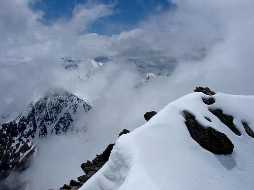 The summit
From the summit I only could see this image of the Valley of La Pez among clouds. The descent is usually done by the same route. Going down, I had better visibility, as you can see in this photo of Culfreda.
 Valley of La Pez
 Peaks of Culfreda
Essential Gear
Not technical equipment required. Only the adecuate clothes and individual elements (sticks if you want, ice axe & crampons in winter, etc.) for high mountain hiking in temperate areas.External links
If you don't understand completely the text on this page or you want to practice another languages or simply you are a little eager, you can find the original issue in Spanish in the website Pirineos3000.com(la versión original en español de esta página se encuentra en Pirineos3000.com)