
-
 3140 Hits
-
 78.27% Score
-
 9 Votes
|
|
Route |
|---|---|
|
|
28.91868°N / 13.78422°W |
|
|
Hiking |
|
|
Spring, Summer, Fall, Winter |
|
|
Half a day |
|
|
Hike |
|
|
Overview
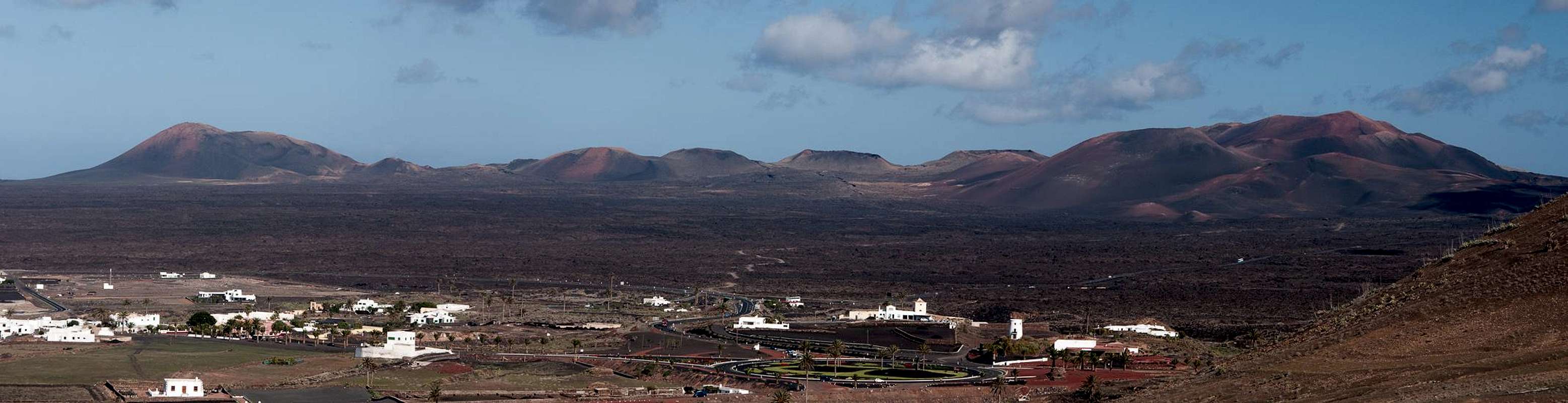
 Remains of a windmill in front of Montaña Chopaderos and Montaña de Guardilama Remains of a windmill in front of Montaña Chopaderos and Montaña de Guardilama |
Atalaya de Femes is not a difficult mountain to get at. There are many possible routes out of which two stand out. The direct route from the village Femes follows the maintenance road for the radio installations on the summit and thus is only of medium interest. The north-east ridge route from Yaiza is different, however. While it also follows roads for part of the way, the north-east ridge is very panorammic. Only at the very end - right before the summit - you'll join the maintenance road for several hundred metres.
The route is long and dry. The first part crosses Valle de Fenauso with its lava fields and vineyards only to steeply climb towards the north-east ridge via a field road. The ridge itself is more or less path-less. There are several steps in the terrain, which can become challenging in the Canarian heat. A final traverse leads to the maintenance road, which takes you to the summit.
Getting There
  |
See the Getting There information on the main page for the description of how to reach Yaiza.
Route Description
 Montaña del Medio, Montaña de la Cinta en route to Atalaya de Femes
- Start altitude: 185m
- Summit altitude: 608m
- Prevailing exposure: North
- Type: Hike
- Protection: None
Assuming you start the route from the church at the town centre of Yaiza you need to follow the road which heads southward in the direction of Valle de Fenauso. On the left hand side you'll see a large children's playground, right after which the road runs into a roundabout at the end of Yaiza. Turn left there and follow the street towards its dead end. Where the paved section ends a dirt road continues leading up the west slopes of Montaña Miguel Ruiz, which separates Yaiza from neighbouring Uga. The road turns steep but offers good views of Valle de Fenauso and Montaña de la Cinta. At the top you'll come across the remains of an old windmill, where a secon trail from Uga joins.
The road now turns even steeper yet and heads up the west slopes of Caldera Riscada towards a saddle. There it continues to Femes on the other side of the ridge. Instead, remain on the ridge (a visit to the rim of the Caldera is possible), turning right, i.e. westward. There are tracks which you can follow but they are a bit ambiguous. Simply stay on the ridge and head for the top of a step which separates the saddle from the remainder of the north-east ridge.
 |  |
On top of the step the ridge becomes flat for some time. Here,, again you'll be able to find tracks to guide you to the nextchange in terrain. A second step takes you to the highest point of the ridge from where the remainder of the route is easily visible. The climb to this highpoint is the steepest part of the whole route. After this summit the ridge descends into a saddle again, where the maintenance road joins heading up the mountain from the south from Femes. Turn on the road, heading northward and passing a spur of the Atalaya. The road circles it and heads back to the south, touching the rim of the little crater of the extinct volcano. From the crater a short hike takes you to the summit. Be sure to walk over to the other (southern) side of the antenna installations for the view of the southern tip of Lanzarote.