
-
 4182 Hits
-
 76.66% Score
-
 7 Votes
|
|
Route |
|---|---|
|
|
47.85389°N / 112.82315°W |
|
|
Scrambling |
|
|
Summer |
|
|
A long day |
|
|
Class 3 |
|
|


Overview
This route approaches Old Baldy from the north. Route Creek Pass is itself an excellent destination, and the climb along the north ridge of Old Baldy offers sweeping mountain views in all directions every step of the way. At about 14 miles RT with 4000’ of elevation gain, this route makes for a long day. With care, a climber can keep the route at Class 2+, but s/he is almost certain to encounter some Class 3 spots.
Climbers might consider backpacking in and camping in the vicinity of Route Creek Pass instead. An advantage to this aside from breaking up the climb is that it also offers the possibility of climbing Teton Peak, which is along the ridgeline to the north. That is what I did, climbing Old Baldy in the late afternoon and climbing Teton Peak the next morning. Be forewarned, though, that Route Creek Pass is a terrible place to camp; it is rocky, and there are no flat spots. The nearest flat spots (still rocky) are reached by climbing a few hundred feet above the pass along one of the ridgelines north or south. There are also no trees for hanging food, so it is best to have a bearproof canister for storage of food and other items that emit odors.
Getting There
About five miles north of Choteau, look for a west-heading road with signs indicating fishing and access to the Teton Pass Winter Sports Area. Take this road. 17 miles along, a road will branch left, cross the river, and become gravel. DO NOT take this road. Instead, stay straight (a sign will say you are on 144); the road will soon turn to gravel (well-maintained and probably passable even to a Corvette), enter the mountains, and take you through some gorgeous mountain scenery that almost no one outside Montana knows is there. The Cave Mountain Recreation Area is about 5.5 miles from the fork. Turn there and follow signs to the Middle Fork Teton (Route Creek Pass) Trailhead.
Route Description
The trail to Route Creek Pass follows the South Fork Middle Fork Teton River (yes, that is the name) for 5.5 miles from the trailhead, climbing 2100’. That sounds pretty gentle. But wait. For 4 miles, the trail only climbs 1000’. After a stream crossing at 4 miles in, the real climbing begins, and the last three-fourths mile is especially steep; given that you will probably be hot, tired, and thirsty by then, you will likely be hating every ounce in your pack. Excellent scenery for the last 2 miles helps compensate for the strain.
This trail was rebuilt a few years ago, but the old trail, which stays lower and closer to the river, is still there. It doesn’t make much sense to use the older trail unless you absolutely cannot tolerate sharing trails with horses; Route Creek Pass is an important gateway into the heart of the Bob Marshall Wilderness, and horsepackers use the trail regularly (so expect mud and manure).
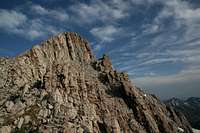
During the final approach to the pass and from the pass itself, the entire ridge route is visible. Some of the sections just below the summit may look challenging and possibly technical, but relax (or sigh with disappointment); they are easier than they look (but you can make the climb harder if you want to).
After resting atop the pass, head up to the ridgetop. This might actually be the most unpleasant part of the route, as you have to slog your way up loose scree. Look for a goat trail angling slightly northwest up the slopes; it helps, even though it’s not direct.
For about half its length, the ridge is pretty gentle and makes for pleasant hiking with increasingly outstanding views. To the south, some of the other major named peaks of the Sawtooth Range begin to stand out: Teton Peak, Mount Lockhart, Mount Wright, Choteau Mountain. If you have a map, you might notice with some perplexity that the peak just south of 8416’ Teton Peak, Point 8779, is most certainly not higher than Teton Peak. You are not disoriented or in need of improving your map-reading skills; Point 8779 is actually about 8175’, making a climb of Teton Peak much easier than a map study seems to suggest.
When the ridge begins to noticeably steepen, it also becomes much rockier, and it is time to pay more attention to the climbing than to the scenery around you. Although the crest of the ridge is uneven and rugged, it is solid (the sticky limestone provides great traction), and it is much easier going to stay on the crest as much as possible and avoid the scree just below it on both sides. If you’re very careful or very lucky, you’ll encounter no more than a bit of 2+, but it’s almost certain that you’ll run into some Class 3 spots, especially during the last few hundred feet to the summit. If you find yourself facing Class 4 or harder and don’t want that, just backtrack and look for an easier way.
There is a cairn atop the summit but no register, which is typical of the peaks out here.
The USGS Cave Mountain, Mount Wright, and Our Lake quads show the trail. Unless you want to have all those maps to figure out where you are at any given time, it really is only necessary to use the Our Lake quad if Old Baldy is your sole destination. That map shows both Route Creek Pass and Old Baldy.