
-
 3093 Hits
-
 71.06% Score
-
 1 Votes
|
|
Route |
|---|---|
|
|
38.90710°N / 106.3675°W |
|
|
Hiking, Scrambling |
|
|
Spring, Summer, Fall, Winter |
|
|
One to two days |
|
|
Class 2+/3 |
|
|
Getting There
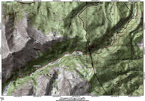 The appoach topo
Northeast Ridge
RT (from Bedrock Falls): ~ 7 milesRT (from Pine Creek Trailhead): ~24 miles
As mentioned in the mountain page, climbing Silver King Peak in a day would be a large, but not undoable undertaking. The approach hike is long, but on a very well developed trail. Highly recommended is a backpack trip to the lovely Pine Creek valley.
If you’re starting from the Pine Creek Trailhead, first of all pay your dollar to cross the private land owned by Pine Creek Ranch. The first mile or so follows a wide 4WD road and is very flat. The very sandy trail beelines through a nice meadow before exiting private property and entering National Forest. The first part of the hike is wonderful, with a still very gentle incline and great forests replete with giant boulders. The trail eventually meets up with Pine Creek and for the most part follows it as it cuts its way up the valley.
From 9200’ to 10400’, the trail becomes slightly steeper. At 10,400 the trail abruptly becomes gentle and you cross a wooden bridge which signifies where the Colorado Trail crosses the Pine Creek Trail. There are a number of excellent camping sites near the junction and also some less than a tenth of a mile up the Pine Creek Trail. The next few miles are pure backpacking/hiking bliss. You are bracketed on both sides by 14ers (Oxford to the north, Harvard to the south), the trail is soft, easy, and gentle and the sights and sounds are unrivaled. There are countless excellent camping sites north of the trail.
At 10,720’, the delightful Uncle Jon’s Cabin situated right across from South Pine Creek makes an appearance. From the cabin, continue along the trail towards the west. The trail became a little steeper as the valley cuts up near the Bedrock Falls. This is the steepest part of the approach hike. Take time to enjoy the Bedrock Falls at 11,200’! The trail continues past the falls and you reach an intersection with the Elkhead Pass Trail at 11,520’. After passing the junction, the trail becomes significantly fainter. As the trail approaches 12,000’ it veers towards a large marshy area. It is easy to get off trail here so keep your eye out for the spot where the trail, which up to this point has followed the north side of the creek crosses the creek to the south side of the valley.
The trail in the headwaters of Pine Creek is better defined and leads you into the hanging valley containing Silver King Lake at 12,634’. From the lake, spot the trail that passes a collapsed cabin and begins up the ridge which lies to the east of the lake. The trail is pretty good and takes you up steeply towards the saddle between Silver King Peak and Point 13,352’. There are a few areas along the trail which are hard to follow as it crosses wide talus fields. Take care here as much of the slope is somewhat loose. The final 100 feet up to the saddle is a scree/talus grunt but you will be rewarded with the views to the south (Yale has never looked so good!)
The trail ends here and it is about a 600 foot Class 2+ scramble up the rocky ridge to the summit. For the most part it is recommended to stay on the ridge as the rock here is most stable. There are a few spots where you can venture into fun Class 3 scrambling and the exposure is neither remarkable nor negligible. The eastern summit is the higher of the two and is a sublime experience and most likely a secluded one. Return from whence you came! It’s only 12 miles back to the car.
Essential Gear
This is most likely a backpack for most due to its length (24 miles RT). Non special gear is needed for the hike up Silver King Peak. This route would likely be dangerous in winter due to avalanche possibilities along the route of the trail.Route Topo
 The Northeast Ridge topo