
-
 20949 Hits
-
 76.95% Score
-
 8 Votes
|
|
Mountain/Rock |
|---|---|
|
|
38.90710°N / 106.3675°W |
|
|
Chafee/Gunnison |
|
|
Hiking, Scrambling |
|
|
Spring, Summer, Fall, Winter |
|
|
13762 ft / 4195 m |
|
|
Overview
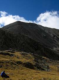 Silver King Peak from Silver King Lake
If you love the Sawatch Range and the Collegiate Peak Wilderness, you owe it to yourself to give Silver King Peak a shot. From its lofty summit, the views of nearby 14ers Mount Harvard, Mount Belford, Mount Oxford, and Missouri Mountain are unparalleled. And unlike those peaks, you’re almost guaranteed to have the summit to yourself!
Getting There
Silver King could be reached from a number of different routes; up Pine Creek, from Texas Creek, over Elkhead Pass or Clohesy Lake, however Pine Creek is likely the most often used and is therefore described here.The Pine Creek Trailhead lies at 8,800 feet. From US 24, 6.3 miles south of the U.S.24-CO 82 intersection, turn onto Chaffee County 388. Continue straight at 0.3 miles and around a sharp turn at 0.6 miles where the road gets a mite bit rougher. Low clearance cars might want to park here, while others may continue up the last tenth of a mile to the trailhead. The trailhead lies on the boundary of the private Pine Creek Ranch. (see Red Tape).
The Pine Creek Approach is about 8.5 miles from the trailhead to the Bedrock Falls. A topographic map of the appoach is HERE
Red Tape
The owners of Pine Creek Ranch request a token one dollar per person charge (a little more for quadripeds of any sort) and since private land owners allowing access to their land for a dollar is quite a steal (lest we forget the snake of the south), make sure to pony up the cash in the name of landowner/hiker relations. The first half mile to a mile of the Pine Creek Trail is on private property so make sure to show respect to the land as well as the land owners.Camping
There are numerous great campsites sprinkled through the entire Pine Creek drainage. You should have no trouble finding a place that has already sheltered other backpackers so please don’t disrupt a virgin site, just hike a few more minutes, you’ll find a great one, already set up with sitting logs and fire rings!Great camping spots can be found after a short hike right after the Pine Creek Trail intersects the Main Range Trail (Colorado Trail). We camped a few miles further west on our second night out. There are some nice camping spots within close proximity to Little John’s Cabin. Good camping spots 5 to 10 minute hike west of the Bedrock Falls are highly recommended as well. For those wishing a longer backpack in, no better place can be found than in the high basin containing Silver King Lake (don’t forget to camp at least 100 feet from water). Expect some winds here!
Wherever you decide to camp remember that you are within the Collegiate Peaks Wilderness and to observe all USFS regulations. Most of all, LEAVE NO TRACE.
Bedrock Falls
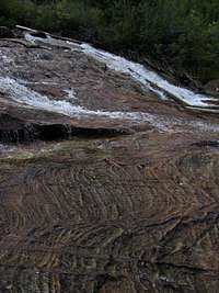 The Bedrock Falls