
|
|
Route |
|---|---|
|
|
39.47750°N / 106.46°W |
|
|
Scramble |
|
|
Most of a day |
|
|
Class 2+ or Class 3&5 |
|
|
II |
|
|
Introduction
While this is the classic and easiest route to the south ridge of Notch Mountain and the Shelter, it is not the easiest way to get to the true summit of Notch Mtn. Between the shelter and the summit, Notch Mountain’s namesake notch blocks easy passage. While northern side of the notch rises fairly gently, the southern side rises abruptly in a cliff. There are two ways to deal with the southern side, either traverse around it to the west, or attack it end on. The traverse requires routefinding and class 2+ hiking/scrambling, while the direct attack has a single and somewhat exposed class 4 move at the top. Due to the complexities of getting past the notch, I don’t recommend this route to someone who is uncomfortable with their routefinding abilities. If you do run into trouble north of the notch, just take the Half Moon Pass / North Ridge Route back to the trailhead.Roundtrip: 9.5 miles, 3,480 ft. gain
With return via Half Moon Pass / North Ridge Route: 7.55 miles 3,130 ft. gain
US Forest Service Notch Mountain Trail Overview PDF
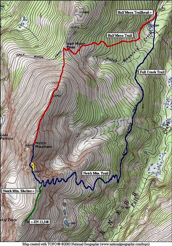
Blue: Notch Mountain Trail route (with class 2+ traverse)
Yellow: Optional class 3&4 “direct assault” option
Red: Optional loop route return via the Half Moon Pass / North Ridge Route
Approach
Start at the Half Moon Trailhead. Two trails start in this immediate area, and hikers have confused them. Take care in making sure that your are on the right trail! Standing with your back to the Tigiwon Road you drove up, to the right you will see the usual trailhead regulation sign. The Half Moon Trail starts off past the sign and begins to angle off to the southwest. This is not the correct trail for this route. The Fall Creek Trail starts off to the left in the trees and shortly crosses a creek and heads south.Take the Fall Creek Trail as it proceeds south. (If you find yourself on a trail that shortly starts climbing off to the southwest, you’re on the wrong trail. Go back to the trailhead or bushwhack east to reach the Fall Creek Trail.) At 2.25 miles form the trailhead, you will come to the intersection with the Notch Mountain Trail, I believe that this intersection is signed. Turn west and take the Notch Mountain Trail as it climbs upwards. The easy part is over and the elevation gain really begins!
Route Description
Follow the long worn Notch Mountain Trail as it winds its way up the side of the mountain. The trail climbs a little over 1,900 ft. in just over two miles. As the trail tops out on the Notch’s broad and gentle south ridge, to your left you will see the Notch Mountain Shelter; Notch’s summit lies to your right.Turn right and hike north towards Notch Mountain’s 13,224 south sub-summit. Make your decision which route you are going to use to deal with the notch.
Class 2+ traverse:
Near the sub summit, head towards the western side of the ridge and start looking down for the line you want to take for your descending traverse. On your traverse, you need to loose about 170 ft. This traverse descends talus and broken ledges. You want to wind up a little bit below the bottom of the notch on the western side. Once at this point, hike/scramble up into the bottom of the notch. From here, climb up broken ledges on the eastern side of the ridge crest. The angle will ease as you ascend. Hike the last 10th of a mile to the summit.
Direct cliff assault:
Follow the ridge to the point at which it ends at the cliff drop off. A few feet before the final stone, look to your left (west). You will find a place where a step drops off for roughly 6 to 8 feet to a ledge below; this ledge is probably about 6 feet wide. Beyond the ledge, the cliff drops off to the bottom of the notch roughly 100 feet below. Carefully drop/downclimb the step (this move isn't very difficult). To the west you will find a convenient and comfortably wide ramp that descends to the bottom of the notch. This ramp is class 3 and is rather exposed. From the bottom of the notch climb up broken ledges on the eastern side of the ridge crest. The angle will ease as you ascend. Hike the last 10th of a mile to the summit.
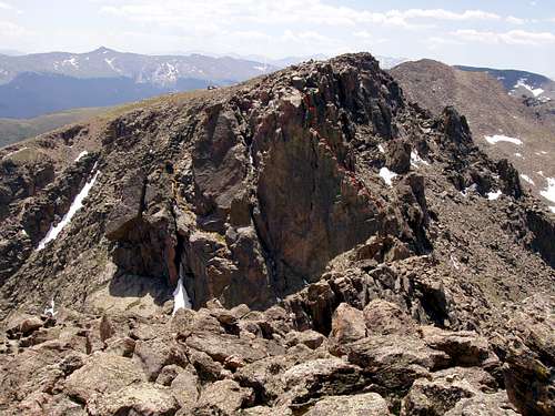
"Direct Assault" route in red
To return via the route you came:
Return to the bottom of the notch, climb back up the ramp to the ledge below the step. To get back up the step requires a class 4 move. Taller climbers will find the move easier. I am only 5’5” and I had to first hang by both of my hands from the step’s edge, then lunge up to a hold out of sight on top of the step. There are no good holds for your feet. A courte-echelle boost would make short work of this obstacle. If you fall on this move and continue to travel backwards, you may go over the brink and meet a fatal fall—be careful! If this move defeats you, relax, you still have two other options.
Essential Gear
No special equipment is necessary. Be sure to carry the essentials for backcountry travel. Due especially to the fact that so many people have gotten lost in the area around Mount of the Holy Cross, bringing a good topo map and compass is a very good idea. Be sure you know how to use both of these important tools; they are worthless if you don’t!Camera! The summit of Notch Mountain is the classic view of Mount of the Holy Cross and its namesake cross (season permitting).