
-
 13091 Hits
-
 76.66% Score
-
 7 Votes
|
|
Mountain/Rock |
|---|---|
|
|
37.12400°N / 118.5762°W |
|
|
12960 ft / 3950 m |
|
|
Overview
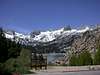
This peak is also informally known as "Trapezoid peak", presumably for the shape of its imposing northeast face.It lies approximately 0.4 miles west of Mt. Goode. Like it’s neighbor, it overlooks Bishop Creek and has good views of Mount Agassiz, Mount Winchell, and the west side of the Palisade Crest. It also provides a stunning view of the Black Divide and LeConte Canyon.
The easiest route (northwest face) is Class 3. The northeast face is a striking near-vertical wall with huge dihedrals and overhangs. I am unsure if any technical routes have been done on it, though it’s proximity to the trailhead and technical routes on the north side of Mt. Goode make it likely that routes exist. This climb can easily be done as a day hike from South Lake.
There is no summit register as far as I can determine, though the peak seems to get a fair amount of traffic, given its proximity to the popular Mt. Goode.
 |  |  |
Getting There
The easiest approach is via either the Bishop Pass trail or from the Treasure Lakes area. In either case, depart from the South Lake trailhead. From Highway 395 in Bishop, take Highway 168 southwest towards the mountains. After fifteen miles, take the South Lake Road turnoff to the south. Follow South Lake Road for seven miles to the parking lot at the end at 9,800 feet elevation.Take the Bishop Pass trail from the parking lot. The peak may be climbed from either the northeast or northwest. The northeast approach follows the Bishop Pass trail about 4 miles to either Spearhead Lake or Saddlerock Lake. From either of these lakes head cross-country west-southwest into the large cirque below the north face of Mt. Goode. The northwest approach departs Bishop Pass trail about ¾ mile to the Treasure Lakes trail. Follow the Treasure Lakes trail until it ends, and then hike cross-country to the uppermost Treasure Lake.
A more arduous approach can be made from LeConte Canyon. Follow a stream that heads northeast from the JMT/PCT about halfway between Big Pete Meadow and Little Pete Meadow upwards about 3,000 feet into a broad cirque. Class 3-4 gully routes lead from here to the summit ridge.
Red Tape
The Bishop Pass trail is in the John Muir Wilderness and is a quota trail. If you will be camping overnight, a wilderness permit is required. No permits are required for day hikes.The south side is in Sequoia NP.