Things are moving slowly. In Sept. 18 I did with my sisters the HLA test at the Hospital, this test will tell us how much we share of compatibility for bone marrow transplantation. The result is yet to come, then I will know more about my future. Meanwhile, feeling much better, I arranged with the friend Sper Flavio Varricchio a "charge" to some of the highest peaks of my country, really daring given my current health circumstances, Sierra Fina. I know, I should not have gone there, but could not stand staying at home watching other friends going to the mountains, then went there keep track on an old project. The company could not have been better.
We plan everything carefully so it could not go wrong, there was no margin for error and that is how the traverse happened in almost 99% of the adventure. The therm "old project": For almost two years there is the idea of measuring a mountain which little numbers of hikers visit by doing the Sierra Fina traverse, one of the five most popular traverses in Brazil, Plane Crash Peak (aka his less publicized name: São João Batista Peak).
The mountain has a bizarre history, on January 5, 2000 an airplane single-engine, number PT-KMB left the Campo de Marte in Sao Paulo, flying to Juiz de Fora, Minas Gerais. Shortly after it crashed against the peak beside Pedra da Mina. There were four occupants, unfortunately none survived. The bodies were recovered and taken to the neighboring municipality in Cruzeiro, São Paulo. The wreckage has never been removed and since then, almost 13 years ago, curious climbers/ hikers visit the remnants of the aircraft on the mountain.
The first time I went to Sierra Fina I have seen the plane there, but did not research anything. Air accidents are common in the mountains of Brazil. In Sierra Fina, in 3 States Peak, another disaster has happened where everyone died. In Sierra do Mar in Paraná State, on a mountain called Lontra (neighbor of Agudo de Cotia Peak), there's also a plane crashed since the 1980s. And so on...
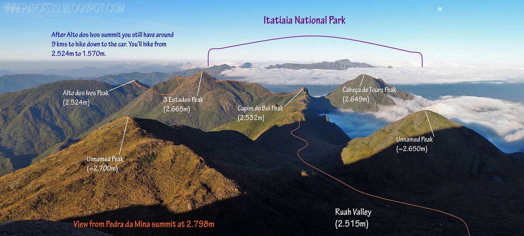
But what struck me was the size of Plane Crash Peak. It's huge (for brazilian standards of course). From Pedra da Mina summit one can note that its size would be at least 2.650 meters of altitude, since it’s little smaller, and very close, from peak to peak in a straight line, the distance is only 950 meters, by trail, 1.4 kms. I decided: "I need to go there!"
But to get there, I would need to hike up Paiolinho route to Pedra da Mina summit and make it a base camp, but as I hiked Paiolinho four times and never did the traverse itself, so never summited before Capim Amarelo Peak, Melano Peak, 3 States Peak and and Alto dos Ivos Peak, decided to face the traverse even with this health problem that can end my life. "Well, if I have to go, I’ll go in great style" I thought.
Of course, momentary exaggeration of the truth. In fact I could have had a "crash" by getting very weak, giving extra work to Flavio and an eventual rescue team. In fact I could have stayed there forever, but I thought this was very unlikely since I felt much, much better than the last time I went to the mountain with Tacio and Aline, this time I reached my limit and had to return alone 8kms of trail to the car, almost dragging myself from the fourth kilometer on.
I promised my reflection in the mirror and my wife and foundation, Lilianne, I would abort the traverse if I felt bad, if I knew my limit was again ahead of the advance of our tent. And I would for sure. Fortunately, my limit was not even close.
I rather unwanted side effects and certainly my anemia got worse. Historically, when I get over the line of 1.800 meters, I have nosebleeds. This happens because of the fragility of my nasal mucous when confronted by hostile drier air and altitude, even that little (but significant for us Brazilians who are on average native of a modest altitude of 500 meters above sea level). When I go to Atacama at 2.450 meters high, desert, that's terrible to me but I deal with it.
This time, the bleeding was so, but so terrible that I had to live 96 hours with continuous smell and taste of blood, so much that I lost. Had to clear my nostrils every twenty minutes to be able to breathe without open mouth, which dries the throat and increases thirst, known problem in Sierra Fina. Flávio was impressed with the amount of blood I was losing. In fact, I left a trail of blood by the whole traverse, over its many miles. I'm almost absolutely sure I collected all my used toilet paper, but if I forgot one or two along the way, please forgive me folks...
The most unpleasant side effect was that: the constant smell of blood in my nostril made me vomit sometimes after cleaning the nose and take off pieces of clotting blood. Very, very nasty. Flavio watched helplessly, and I suffered with the problem my own way: "I got up, kicked off the dust and continued up the mountain".
I spent a total of three full rolls of toilet paper during the traverse (almost a whole roll per day), which caused me also injuries at the entrance of the nostrils, which combined the sunburn got terrible, caused me burns on the wounds. Wow, when I got home and saw the result (state I'm in now) really impressed me. What a mess! But luckily I'm fine and standing on my feet, got a flu, burned skin, herpes attack, infected finger (which I had to cut myself to get rid of the pus and the excruciating pain), but as happy as I can be.
The adventure begins
Ridge stopping the clouds on Capim Amarelo slopes
At 1.850m high, cold!
No more bullshit. I decided to make the traverse, period. Invited also Tacio but he was wrapped with his studies and could not go, a shame because we have ongoing projects together and one of them is to measure and name some of the Sierra Fina mountains. He was cheering from home.
Flavio and I went to Passa Quatro from different points of course, he left from the city he lives, Petropolis (high Rio de Janeiro), and I left from São Paulo where “I survive”. I arrived in Passa Quatro three hours before him and was chatting with a taxi driver, who was gonna do the service of leave us in Toca do Lobo (Wolf's Lair, a small cave at the very beginning of the traverse) and pick us up in Sitio do Pierre (Pierre’s Farm at the end of the traverse). When he arrived we got in the taxi and went straight up the mountain.
The weather was questionable, cloudy, but all the info provided by Mountain Weather Forecasts said to us that for that day, September 26, a few millimeters of rain, but for the subsequent days, absolute sun. Antonio (taxi driver) left us at the altitude of 1.300 meters of altitude. We got out, paid and started walking in the fog that blocked completely our vision beyond thirty feet ahead of us, we had no vision of the mountains. Over time the business was getting wet.
After about half an hour walking, we reached 1.560 meters altitude in the famous Wolf's Lair, a cool cave that may have never actually served of home to no wolf, but this is how it is known. Sits on the edge of a river, and the first steps of the route are the crossing of this river.
It was very humid, we were soaked, and it was late, we would not progress much by following up on this very day, even camping in one of the 29 points along Sierra Fina traverse. Then we came to the joint decision to spend the night there ahead of the cave. It would be more comfortable, dry, and we would start early the next morning. We set up the tent, put clothes to dry inside the cave that is very hot, and we had fun chatting after dinner, sleep afterwords, we had a tough task next day.
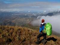
The night was a snap, and I had a glimpse of the much better with the first rays of sun, with most of the light blue sky. We prepared everything and started hiking up. The start was good and hard since we pulled the body out of a state of rest for many weeks and now faces a sloping track right away, wet and slippery. All with weight of backpacks, Flávio’s was infinitely heavier than mine at around 23 or 24 kgs without water. I need to avoid carrying too much weight, because I can get very tired very fast, so my weight was limited to a maximum of 14kgs, without water load. After we got water, my weight increased by 3.5 kg and Flávio’s by 5kgs.
Soon we began to marvel at the views of the Serra Fina, as the clouds drifted away a bit revealing steep slopes. Only one thing hit us at the beginning, it was a bit windy and very cold. More or less windy with 50kms/h winds and temperature was low, around 5ºC, at only 1.850 meters of altitude, the result was a wind chill of 0ºC at least. The beginning was cold and stayed that way almost to the top of Capim Amarelo Peak.
We progressed without great difficulty hiking the famous ridge of Capim Amarelo Peak, first goal of the traverse. The hours passed quickly, the altitude changed fast, and in a blink of an eye we already passed the line of two thousand meters, where we first saw the famous ridge of Capim Amarelo Peak, named “Angels Pass”, vision very easy to take with a quick search on google images. Magnificent view, a session of the ridge that resembles the famous "knife ridges" around Europe or U.S. mountains. So thin, with about a meter wide in one section of a hundred yards of track, if the wind is really strong, a trekker can easily be in danger downhill since on both sides the slope is at least 60º to 65º tilted. Very nice view indeed...
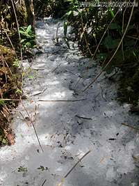
We passed this gorgeous section, and we did some photos. Soon we surpassed the line of 2.350 meters and started the scrambling section of Capim Amarelo Peak, where we had a pleasant surprise, ice on the trail. A little bit at first, but we would find much more along the second and third day...
Summit of Capim Amarelo Peak at 2.500m.
Finally, 5 hours after starting, we arrived at the top of the exact 2.500 meters of Capim Amarelo Peak (Note: The IBGE gives its altitude as 2.392 meters, completely wrong). Rather than the pass on the ridge, biting wind and cold, the summit was a little bit with a heat up moment. Photo time, explored a bit, and then we came to the decision to begin the descent to camp on the opposite side between this and the next mountain, the Melano Peak. We had no vision because of the cloud that surrounded us, so we started to descend after around 15 minutes over its top.
(summit video on Capim Amarelo Peak)
Both checking the route, each with his GPS, though to be an older model, my gps didn’t served of anything with cloudy weather or inside the woods, since getting satellite signal becomes an epic technology chalenge. We found the route of descent and went down. Soon we came to a small forest of bamboos closed, but with incredibly well marked trail, we continued down. After two or three minutes a "dead end". We faced a rock and the trail ended there literally.
"But that thing is a damn thing, we follow the marked trail and this traverse is much repeated by dozens of people at a time, where we did wrong?" I said. Flávio went back looking for our mistake as I analyzed how to beat the rock, with wet and unstable ground that would be difficult but it could be done, but there was no ground on the other side!
Our camp, frozed camp.
Hello there!
Flavio called me, he had found an entrance to the left marked with ribbons. The trail that went down was much, much more well marked than the traverse trail itself. Getting back was a struggle and waste of both time and energy. This was our only mistake all the way, and judging by the state of the wrong track, and extremely well marked with bamboos, cut down, a lot of people miss that point just like we did.
We went down, and this crap just cost us about half an hour. The hours passed and we moved very well despite the bad terrain. After about an hour and twenty minutes, we went down more than two hundred vertical meters from Capim Amarelo summit, at the altitude of 2.280 meters, and we had to hike up 25 meters for somewhere to get to the next campsite the gps was showing us, but we were surrounded by a mist, a very thick one. Both, visual guidance and GPS devices were disoriented because of bad weather, even Flavio's, a garmin 60CSx, most popular among brazilians climbers, excellent hand gps with great results.
We search for different routes, several times, we got very wet, searching like crazy, but the closest we got to the camp was a distance of 62 meters in a straight line. Incredible! There we got nowhere.
We decided to camp right there in the grass because there were two points good for camp, inside the bamboo forest, like a refrigerator that seemed so cold and it was surrounded by ice inside the vegetation, and another one outside the bamboo forest among the high woods, a lot warmer.
We were frustrated, how can a place so close “not want to be found”? Closer than the walk to the bakery in my neighborhood, though as far as the other end of the Sierra. Then a wind blew...When this wind blew, for about 15 seconds, I could see a cairn across the high grass (2 meters high grass), easily visible, going up the gently rocky slope ahead of us. "Flavio, looks a cairn there, let's try again." By this time we had picked up our camp, I had vomited the first time, it was decided to spend the night there. We were trying one last time.
Easy, as easy as taking candy from a kid, and go up the small ramp, a short section of rock with our freezing hands at the point to begin the "pinpricks of cold", until the distance decreased to 50 meters, 40 meters, 30 meters, we found the camp! Damn, at that point the windchill was easily of -5°C.
In this "nature prank" we lose another 40 minutes. The wrong descent track that leads nowhere with the difficulty with orientation to get to our camp, we took twice the time it takes from the summit of Capim Amarelo Peak until such camp, an hour. Our was the poor time of two hours. We finished the walk of the day at 2.305 meters of altitude after seven hours of work.
We set up camp, had dinner, and after that we had fun with the famous little mouse of Sierra Fina, who came sniffing and searching for food. What a curious and stubborn pet. I think about a couple reasons he do not fear us: He see hikers and gets food from them, get used to human presence and not even gets scared, except with sudden movements. After nearly an hour in the fun with the little friend we went to sleep, since it was quite cold already.
We wake up in cold weather, and the sky was super clean, there was not even one cloud in the sky, and the tent was white with morning frost. The temperature in the morning 1.9°C below zero. Big present because we did not expect so. Photos, fun, cold (1: because of my condition, my resistance to cold fell drastically, so I took my pluma jacket with me! / 2: To save weight, took the sleeping bag of Lilianne that is for extreme of +5°C, result: I felt cold feet all 4 days), prepared everything and after a quick breakfast, we continue our road to the first peak of the second day, Melano Peak.
The Melano Peak is a huge massive neighbor to Capim Amarelo, greater than he in altitude, composed by a sequence of five summits, the last one being the highest, which connects Capim Amarelo Peak to the valley that separates Pedra da Mina from Tartarugão Peak, another huge brazilian mountain whose summit I already stepped exactly two years ago. Sept. 23, 2010.
Little publicized, much less counted as peak (for most, not all), actually I would say that Melano Peak itself is more a mountain than Capim Amarelo, taking into account the altitude of the col between the two mountains. But that argument is for another conversation. Hiked the rocky slope of a hillside shortly after we entered the forest after the great camp of Maracanã, twenty minutes after where we sleep. In fact, believe it or not, we climbed the rocky slope dodging ice to avoid slipping and die in the fall. The ramp was frozen! I believe that during the night the temperature was less than -1.9°C, probably around –6ºC or –7ºC, that was the temperature recorded in Itatiaia NP the night before!
Brazilian Ice
wow!
Natural Popsicle!
Frozen flower...
Cool Icicle.
Gradually our water was running out, as we gained altitude in Melano, making the effort to overcome the scrambling sections up and down its summits, under strong sunshine. Then I had a vision almost unbelievable: More ice. Not only more ice, lots of ice! Besides being a completely "appetizing" in the sense of opportunity to witness the phenomenon, there were also the literal meaning of the word "yummy", pure mountain water ice that would kill our thirst for a few more minutes.
What happens is that the phenomenon was Sincelo, known in english as Icicle, which according to wikipedia is "a meteorological phenomenon that occurs in situations of fog coupled with a temperature of -2ºC to -8ºC, and that results from freezing of water droplets in suspension, when these come in contact with the surface of plants. When under a very dense fog, can produce the same effect as a snowfall, occurs and precipitation of ice crystals in full fog, with no cloud in the sky. Not to be confused with frost. The film of ice formed on any surface that is in the path of the fog, giving the leaves and stems of the trees glassy appearance.". When the icicle is very strong, as we saw, the ice crystals grow taking shape of cubes, or ice cubes, and fall from the foliage on the ground because of its weight. In southern Brazil, in Santa Catarina state, is common to see icicles in formats of bunch of grapes during the winter.
(Look, that much ice in Brazil is a rare thing to see!)
Very common in Brazilian mountains colder during the winter, but not in the first week of spring! Photographed, filmed, kill the thirst, and continue. What a gift from nature ...
Brazilian Icicles
Moving on...
Mina Rock summit, again!
Cold!
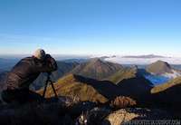
Flavio working
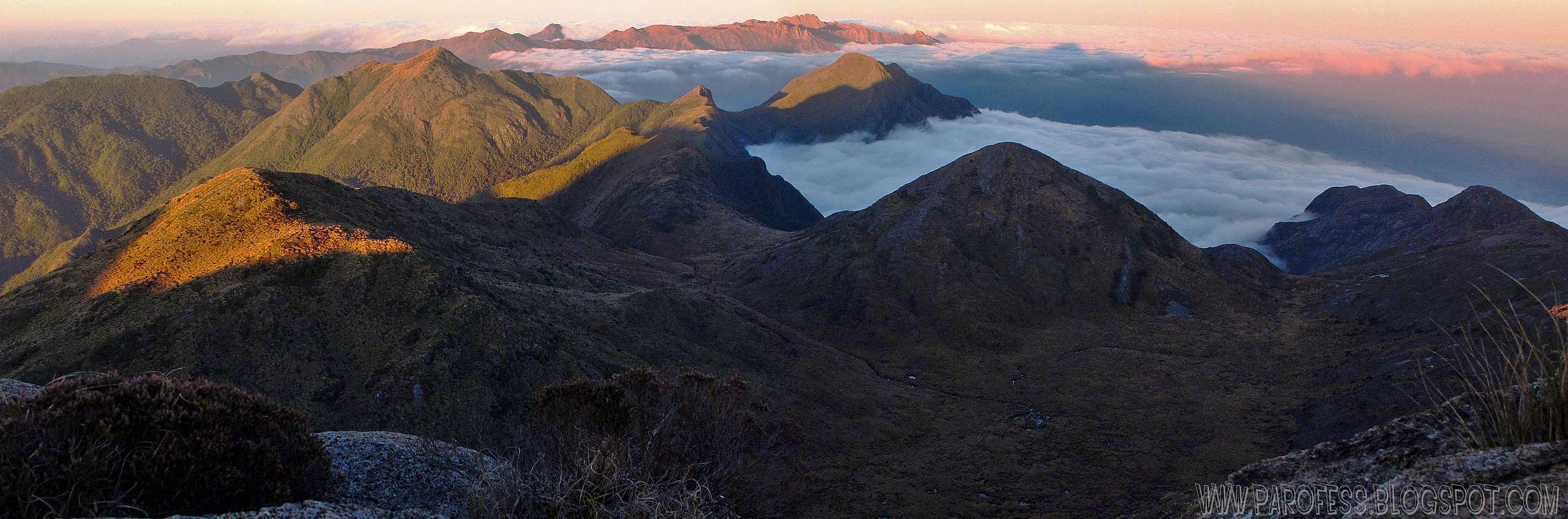
We moved on, passed the highest point where Melano measures 2.566 meters high. We began the opposite descent to enter the enormous valley where the rust waterfall is, already hungry again for fresh water. We passed right by the first water point, arriving in Rio Claro (Claro river) that separates the 11º camp from 12° camp. Finally, large amounts of water...We had about 100ml of water each.
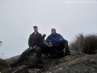
We stopped, celebrate with big smiles showing our lips already cracking from dryness, drunk as much as we could, made lemon juice. It was a fun party and lasted about half an hour including time spent working by Flavio, since for him the adventure of stepping by the first time in Sierra Fina, was also the duty of the photographer's life.
Resumed walking. Now we begin to cross the valley with Pedra da Mina growing rapidly before us. Arriving at the base of the mountain, I had to blow the nose again and there goes all the liquid (juice) that I ingest to hydrate me, threw up everything. Nasty stuff...Put myself together and we follow to climb the west face of Mina, after enjoying the south wall of the mountain.
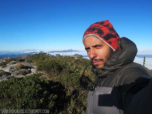
Finally, at exactly 15:00h, stepped on the mountain top, my sixth time and Flavio’s first time on Mina. It took seven hours total again walk from our camp to the top of Mina, including all stops shooting, vomiting, water supply and appreciation of the beautiful mountains. Arriving there early, we had time to calmly choose where to camp since we kept completely alone, assemble the tent, throw up again after cleaning the blood, and prepare to sunset time and the photographs it would provide us.
[My personal number 6 ascent video on Pedra da Mina (Mina Rock) at 2.798m high.]
The temperature dropped very fast, the last time I checked after all our clicks in front of Ruah Valley I also photographed, and it was -2.7°C at exactly 19:14 PM, shortly after the last light of the sun leaving the sky. Just not colder windchill because there was no wind, lucky us hehehe. Overnight not registered, but probably reached -5°C or so, in Itatiaia NP during the same night the minimal was -9°C. Recalling, this was the first weak of spring after a very weak winter of 2012.
We've already rested after seven hours of long walk and another hour of photographic delight that also served as a rest. Tonight we would not need to preserve water because we would have lots of it in Ruah Valley the first minutes of walk the next day.
The next couple of days...
That was waiting for us for the next couple of days in Sierra Fina:
But that I will tell you guys in the second part of this adventure...Say, in a week from now. :^)
Great report, Paulo, was really interesting to read. Must have been quite a trial for you - I don't know if I could have continued as you did under such circumstances!
Your photos are just amazing!!!
Cheers,
Eric
Well...After the two days I was just in front of my main objective, Plane Crash Peak.
And if I felt bad in any way, I could take the Paiolinho route down to a farm, 5 hours of descent instead of another two days on the route to finish it.
But I was okay despite all the nosebleed, vomiting and all that BS.
So I thought, "what a hell, I'll just keep going tomorrow"
Wait for the second part, just about finish the text, it will be on sunday or monday probably.
:)
Cheers buddy!
thank you for posting Paulo - adds fuel to our daydreams about climbing in Brazil :) ....someday. Hope you're doing well (you certainly have been climbing a ton!! :)
Cheers,
Radek
Hey R! Glad to see you visiting. :)
Remember, this is just the first part of the TR, I'll work right now on the second part. :P
Well, no a ton, just seven summits hehehe...
In a few weeks I'll be on the road again, Itatiaia NP. Well, if the rain let me...Rain season now here...
Cheers friend!
Paulo
Parents refers to a larger category under which an object falls. For example, theAconcagua mountain page has the 'Aconcagua Group' and the 'Seven Summits' asparents and is a parent itself to many routes, photos, and Trip Reports.


Comments
Post a Comment