It was dawn on our third day on Sierra Fina, the temperature was much milder at 06:01 am, 1°C. We left the tent, quick breakfast, packed up everything and followed to our first goal (actually my goal) of the day, get to the summit of Plane Crash Peak to do a measurement using handheld GPS. Better yet, because we had two different models. The climb doesn’t have a big secret, just descend Pedra da Mina until the 2.550 meters line, without getting to the bottom of Ruah Valley where altitude varies little and is at around 2515/2518 meters of altitude. At this point there is a small pyramidal summit, we went around it by the left and start hiking up the rocky face, by that route it’s no more than twenty minutes to the summit.
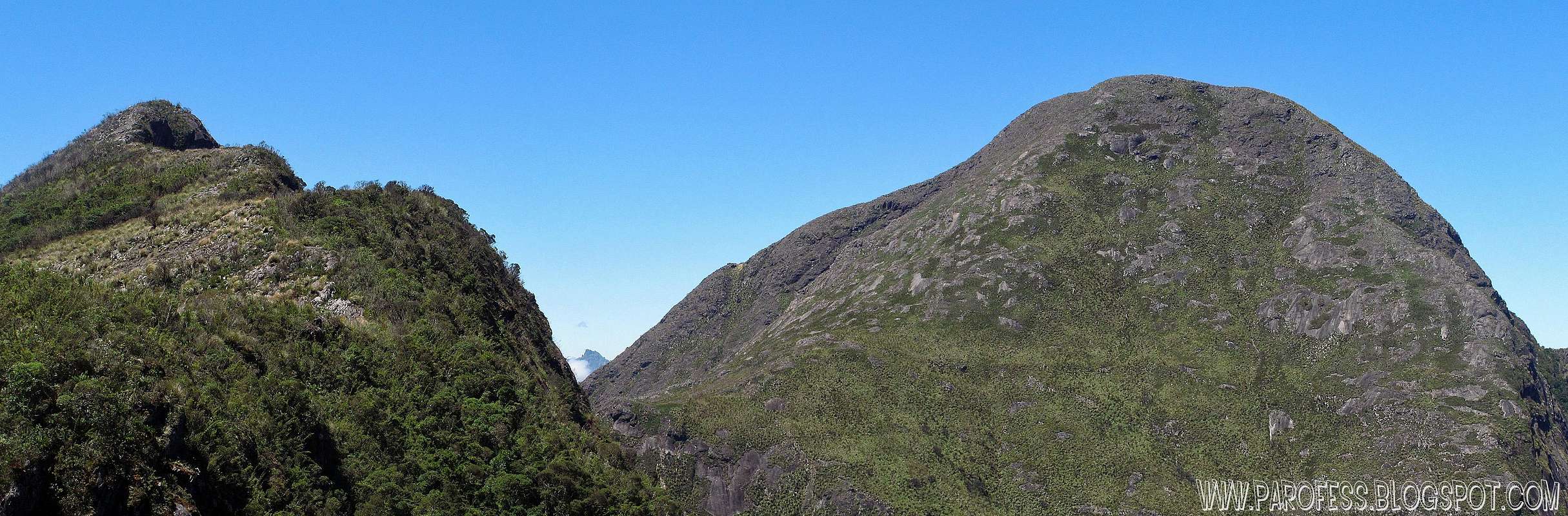
Damn, what a view! The south face of Pedra da Mina saves a impressive secret, reaching the edge of the Plane Crash Peak, looking down, Mina’s South Face has the vision of scary ascent, little frequented route, classified as very difficult, split over two days, starting at the village of Queluz. The altitude gap is grotesque, almost 2.000 vertical meters from the private property where the trail starts. Few seam to have done and that is temporarily closed because the property owner is not allowing anyone to entry his lands. Too bad since this route has a pretty long section of rock climbing too.
But the best view is to east, Cabeça de Touro Peak changes quite a bit, becoming a veritable endless collection of deep cracks, flaws in the mountain. Undoubtedly, one of the most beautiful mountains, and I would say one of the ten most impressive of Brazil. In fact, it has a sub summit down, way down from the main summit, a small hill that is identical to Escalavrado Peak from Sierra dos Órgãos in Rio de Janeiro, very curious indeed!
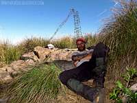
While Flavio worked, I measured the mountain waiting for the GPS devices to stabilize, and obviously also photographed quite a few times.
Garmin Etrex Vista Parofes: Measured from 2.704 to 2.706 meters along six or seven minutes.
(accuracy reported by the GPS: 7 meters)
Garmin 60 csx Flavio: Measured from 2.703 (number which appeared by 2 or 3 seconds and never showed up again) to 2.708 meters over the same time.
(accuracy reported by the GPS: 7 meters)
Based on this, in clear weather, stable air pressure, took as right measuring the smallest and most constant altitude found: 2.704 meters (8.873 feet). Note that, to a precision of seven meters (which is not very safe with handheld gps), this can change from 2.697 meters to 2.714 meters. Only with a geodesic gps to be sure about it (considering my choice of 2.704 meters). Wow, this is high! I expected something around 2.675 meters and it was the altitude I used when I created the page here in summitpost two years ago.
We spent half an hour there over its top, but we did not go to the wreckage of the airplane, I did not want to get tired too soon, because the trajectory of the day I already knew 80% of its total, missing only the ascent of 3 States Peak. I knew that would be a long, hot walk ahead of us. Besides, my physical condition was a constant doubt in a corner among my thoughts. We went down as happy as we could be.
We arrived at the base of Pedra da Mina, at the end of Ruah Valley, at around 09:00am. Between leave Pedra da Mina summit, descend, the summit of Plane Crash Peak, measuring and photographing, down to Ruah, we spend 1h15min. Quick enough. We continue with the traverse of the valley which was much easier thanks to ribbon tapes people fixed, facilitating orientation in the midst of chaotic complex of 8 feet tall wood.
One more gift from nature, the valley was frozen, icicles everywhere, ice crystals of 10 cms in height in shadows, it was past 09:00h, with an approximate temperature of 20°C. The day was gonna be very hot.
We passed through the valley very quickly, in about ten minutes we reached Rio Verde (green river), and continue walking by its margin to the point where there is a "small beach", where Tacio and I drunk from two years ago during the attack on the Cabeça de Touro Peak, there is a stone slab with the crystal clear waters of the river next to the sequence of small waterfalls. I sat there while Flavio was working again, started to wash my face, nose, head, when I noticed a puddle under the big rock that lies on the "small beach" was frozen. A large puddle, which was covered by a layer of 2cm of ice, filmed and had some fun with it.
Colected three liters of water, my small canteen with about 400ml, and waited for Flavio. We drink as much as we could and follow the direction to 3 States Peak still far away, where would be the end our third day. Checking the GPS, there would be another point of water after 3 States at the altitude of 2.025 meters above sea level, which did not seem to be so far at the time. We thought we were good in water supply.
We follow the ridge which hikes up and down a sequence of small summits, four of them, after the end of Ruah Valley, the way gets you tired and takes time, too much bamboos. We move well until we reached the main ridge of Cupim do Boi Peak, beautiful formation of the Sierra that is not really a mountain, but is treated as such by all who go there, and just because of the beautiful view it provides, it deserves the treatment!
We saw signs of recent fire, the vegetation still recovering from it. We found the descent and following cairns we reached the little bamboo forest at the base of 3 States Peak, at about 2.450 meters high. We decided to make a stop for bathroom. Wow, that stop, we stayed there for half an hour at least, after all you have to get to business and afterwords to bury the body hehehe. Lazily we got our backpacks up and started the final attack on 3 States Peak, a little bit tired, but with plenty of time to summit the mountain with the sun up in the sky for at least for hours more.
We gained altitude and in about fifteen minutes we finished the first part. The hike of 3 States Peak is divided into two levels and a ridge, the first step is to regain the altitude lost during the descent of Cupim do Boi Peak, reaching again the line of 2.550 meters. Then there is the ridge that slowly gains altitude and it makes little difference, over about three hundred meters of ridge is gained only about thirty meters. Then, at the end of the second phase of the attack, the altitude is about 2.580 meters high, and the more demanding is to come, the final 85 vertical meters, scrambling.
Begins by crossing tall grass again and then the scramble section alternated with tall weeds, very inclined. At the end of the day, we were tired as hell. Raise the body and backpack at parts whose slope is more like climbing is tiring, all at 30°C in the sun, without one single cloud, and saving water, thirsty. Oh yes, and still bleeding like a pig.
Fighting the altimeter and GPS against my narration that only got out stern expressions from Flavio (Rah! Laughs), finally, at 14:57h, we reached the tripod from the summit of 3 States Peak, at 2.665 meters of altitude. Also located a high "mast" that I suspect had once supported a flag, do not know the history of the structure.
Again, we have maintained an average of seven hours of hiking, this time minutes before completing the cycle of the seventh hour, including hiking up Plane Crash Peak, photo time spent, stop at Rio Verde for about half an hour, more photos, stop for bathroom for half an hour at the base of the mountain. Look, we were very well I can say that! A fortyish photographer and a bone marrow sick dude just a couple months away from the 35th birthday, what a team hehehe!
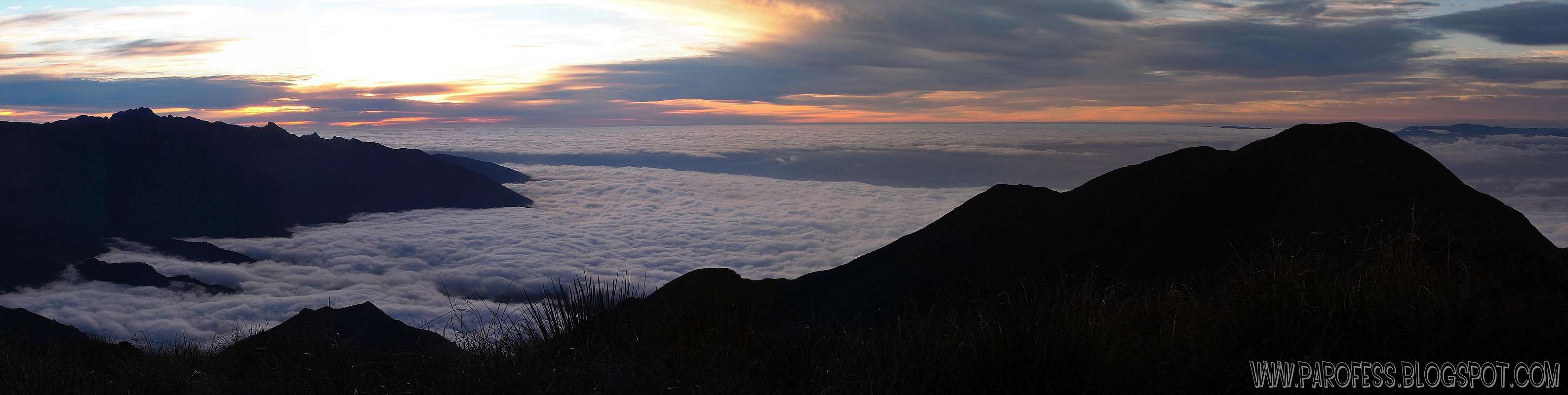
We set up the tent, and during it we were well rested. We spend some time choosing since almost all points have stones on the ground. We ended up right next to the tripod rebar. We made a snack, and we await the hour of sunset to photograph the colors again on all Itatiaia massif in the other side of the deep valley which separates both Sierras, in addition of course to register the birth of the Full Moon. Okay, when the time came we spent an hour just photographing and filming.
On the opposite side, the sun set beside the Marins - Itaguaré mountains in a curious way, I could not see the "ball" of the sun itself, but a curious shape that reminded me of cigar smoke on Woodpecker cartoon. A spectacle. Between us and the sun, layers and layers of mountains...
Soon night fell and went to sleep thinking about the amount of water and the long descent we had to civilization on the fourth day. From the top of the mountain we could see the hike trail of Alto dos Ivos Peak. In fact, I had never saw even one photo of the mountain and firmly believed in a nice ridge that someone gave a name, but the format is very beautiful, pyramidal mountain shape! The hike is all marked and is visible even at almost two kms away from where we were, and the Picu Stone as background was indeed beautiful.
The night was less cold, not even negative temp and no wind, clear aky. When morning came it was 3°C and there were some cirrus above us, high altitude cirrus clouds, and overall weather seemed very stable, GPS kept the same pressure, unchanged. It would be a hot day again, and away from water! One detail, the point marked by Tacio, the water point said "little water", therefore we had no sure if there was running water. By the time I was fixing my stuff inside my backpack I noticed a Walking Stick Insect (Clonopsis gallica) inside the tent. Second time this happens to me, the first time was in 2009 at Alsene campsite, Itatiaia National Park. We had fun shooting the curious bug.
We wanted to get out early, and then we start to fix everything. Again, the route was clear and we lost altitude rapidly coming to a small summit below 3 States Peak, a sub summit of it, we passed, descended the very steep trail on the opposite side to the ridge that connects the massive 3 States with an opposite ridge composed of three small peaks before Alto dos Ivos Peak. It was really hard to climb each of the small summits under the serious sun. Face, arms, neck, all burned enough already without any protection. I thought there would be some protection of clouds even in good weather and so I did not take sunscreen to save weight. Very, very bad ...
Descend to the bottom of the valley that separates the three summits from Alto dos Ivos Peak, reaching altitude of 2.390 meters, already low. Now the worst, we had to hike all over again to get to the top of the mountain, because the descent route would only begin from up there. Hard! The sun mistreated us, the water was in economic status, the temp was easily around 32°C or 33°C, and windchil, it felt like around 40°C . Folks, this was terrible...
The hike was less painful than we thought, and we still afford to drop our backpacks on top of 2.524 meters at the summit of Alto dos Ivos Peak to photograph. Only for about ten minutes, because the heat was absurd, not half an hour like the other times. We resume the long way down.
We went down all the time by the rocky ridge to the altitude of 2.300 meters, when we enter some vegetation of what? Bamboos again. But that damn bamboos never end! Fortunately there was already the limit of it, and little lower after that the backpacks pulling would be over. We reached the twentieth something camp at 2.252 meters. It seemed that now we would start to lose altitude by the time Flávio’s water was over.
Now we just had my water that was in the end too. When we left 3 States Peak he had 2 liters of water and 1.4 liters. How much do I have now? Do not know and did not look at not to worry myself. We went down.
Down? But what kind of descent trail is that? It hikes up more then down!? Everything we descended we returned to hike on the other side, a sequence of some small summits, where there was a lot of barbed wire spread through the mountains. Why? Don’t know. After some time we got down a little reaching the altitude of 2.100 meters and keeping that line for an eternity, at least this time the trail was well open and enjoyable, protecting us from the terrible sun. My water ran out, and Flavio would not drink any every time I asked if he wanted to. I knew he was very thirsty.
I looked at the GPS, there was 650 meters in a straight line to the point called "little water". We went toward the point like batman towards Joker. We walk a relatively long time without changing a single meter of altitude and I came to play with Flavio: "Dude, let's get out of here and just register at the entrance of Itatiaia NP, because we're getting there man!" A slight descent began, the trail ended and became an old unused road with undergrowth vegetation at about 2.050 meters high. Shortly after we arrived at the thin line of water, and there was water! Wow...kill whoever was killing us...
We still had miles of walking ahead without knowing the worst on the roadwas yet to come. After the end of the trail, follow the old road until we lose altitude in each curve coming to a place that I believe to be the Pierre Farm itself, some buildings around a huge green lawn at 1.830 meters. Finally got cell signal and called Antonio, the taxi driver, to pick us up.
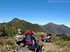
Photo area, the last day
Going back to civilization
Except that his car does not get to Pierre’s, we had over 2 to 3 kms down the road until reach the real road that connects Itamonte county to Garganta to Registro (Itatiaia NP entrance). It was the worst kilometers, much, too much sun. My arms and face were already so badly burned that the mere glimpse of sunlight my arm hair got fixed high like an arrow by so much skin sensitivity. Today I know that I suffered burns on my face, altitude sun burn, which is much, much worse. It seems that I was the victim of an accidental fire while firing a barbecue place, nostrils, nose and cheeks roasted.
We went down and complaining about the lack of sun protection, our guilt, humans that deforest everything indiscriminately. We spent the whole time without finding a single person. The only home we saw a person, this person turned back and got inside his house, probably avoiding having to give water or any unwanted contact with the hikers that in the eyes of the locals, can be mostly bad people, troublemakers. Unfortunately many are, then I do not blame them.
Passa Quatro county
I screamed with my GPS that couldn’t get a signal with blue sky, I was looking to how much we were missing to finally get on the asphalt road when suddenly, after a curve, there it was at 1.580 meters of altitude. THE END! After walking for 6h45min we finished our fourth and final day.
We sat in the only part of shade there was. Finally handed my points to the hematologic fatigue, psychological, general. I collapsed on the grass after increasing my hiking speed day after day, walking each time better than the day before. It fell to Flavio's mission to worry about anything, I was just too tired for some time.
Antonio arrived with a company ride, parked, and then immediately left with the car. He didn’t see us! Well Flávio was still working so he would worry with that, because I was bleeding on the grass, he stood and began walking down the road with my phone in hopes of having signal. Nothing. TIM (cell phone company) is a total crap! Then I went back to work, and while Flavio was walking down the road I started walking up, I only needed to walk twenty meters, Antonio returned with his cab.
We went in and hit the road. We stopped at a restaurant / hotel where I slept in 2008 before going to Itatiaia NP, and against my principles drank a Coke, my body was asking for sugar and it was the first thing I saw as I went inside the place. We returned to our taxi and continue until you reach Passa Quatro county after 55kms of road, in Serra Azul Hotel, in front of the old train rail line of Passa Quatro, now disabled. Only works for Maria Fumaça Touristic Train, it goes up to a certain altitude inside Mantiqueira Sierra within forests, from Thursday to Sunday. I want to take Lilianne to do this ride!
Even before we left the mountain we decided to sleep in Passa Quatro to wash the body, photograph the city a little and eat a decent meal. Incidentally, I would not want to sit next to me in any bus, my smell was a combination of old stinky arms + blood + bad breath from hunger. A human garbage. I did not want to bother anyone with it.
We registered in the hotel very fast and very simply: "My name is Paulo and his Flávio". We took the key and went up to the room. I did not want to contaminate the environment with my smell ... ahahahaha
The room was as simple as possible, the bathroom not even had curtain. Flavio was showering while I counted the wounds and took the plates of blood from the nose, ending my third and last roll of toilet paper. The first day I took a stumble on a stump of bamboo badly cut and I got a terrible bruise on my leg, which was already much better. My toes hurt a little, but not much. The worst was the burns, which could only realize the crap it was at home now because my friends, not a pretty sight! lol
After cleaning, we went to get food in sunday, in Passa Quatro. Ah! No! Seriously? Everything closed, the only people on the street were all in fancy clothing as looking foward to a pawn cowboy party, but it would be a political rally, where? At our doorstep, right in front of the hotel. I went through the boarding house where I ate when I arrived in the city, "Pensão Dona Filhinha", it was closed. Luckily, Soraia, landlady kindly made us enter the room of the house and served us so we didn’t stay with hunger. As lions, we eat a dish made for construction workers, dishes so deep that seemed to never end, even after a hundred bites.
We came back through town and after passing by the hotel to pick up my camera to photograph the sunset. We spent some time just relaxing at the hotel and talking about several things and the traverse as the crowd took care of the front of the hotel, where there was already a truck with stereo equipment waiting the time to start the “party”.
Around 20:20h we went out to eat again, and believe it: we had space inside the belly! We look around until we found a place that sold sandwiches, ice cream, juices. At the sound of motorcycles being destroyed, fireworks, loud cars with propaganda songs, and the whole town parading in high heels and emo hairstyles, each one ate his huge sandwich, a good one I might add. I drank two natural orange juices, liquid with which I dreamed for the past two days. Then we went back to sleep.
Contrary to what we think, that it would be impossible to sleep with so much noise and surrounded by fiery speeches about failure of one, and mistake of others, other people asses, in ten minutes Flávio already snored and I went to this distant planet ten or fifteen minutes later.
Woke up early, before seven. Flávio went out to shoot, work some more, and I was lazy lying when he returned nearly an hour later. So we manage to get our things inside the backpacks, have breakfast (which was better than expected!), and we left the hotel. We said goodbye at the bus station and Flávio went his way on the 08:40h bus to Cruzeiro county, only the first of a sequence of three to get home in the city of Petrópolis.
I waited to nine in the morning, grabbed my backpack and started walking around town looking for a gift for Lili. I found a small gift shop in front of the main square that accepted debit card, what a miracle for such small town! The owner was sympathy in person, chatted with her for about ten minutes while I chose the adornments and paid. I went back to the bus station ten minutes before my bus, and on the way even photographed a beautiful flower in the square.
Well, that's it. Long adventure, one of the best I've ever had in the mountains of Brazil, my country, contrary to what the “gringos” think, hell we have a lot of mountains! Regarding the title of the story (in portuguese it was “ It wouldn’t be so much fun with health”), a joke with serious matter aside, the Sierra Fina traverse is not as hard as the rumor goes, people here (agencies) use to say even at these days: “The most difficult traverse of Brazil”. That’s a lie, not even close. Even with my blood oxygenating at 60% of normal, which makes me feel like at 4.500m even when I am at 2.500m, with lack of oxygen, I did complete the traverse without major complications. The Sierra Fina is not a tour I can tell you that, but it's not such big deal too.
I would like to place on record two important acknowledgments:
First to Sper Flavio Varricchio, who proved to be able to perform a tremendous partnership over the mountains, making me feel as comfortable when I walk with my other older partners Pedro Hauck and Tacio Philip;
Second to Tacio Philip, whose marking points gave us sure of each step during the traverse, perfect markings, accurate. Dude, again, you should have come with us!
Parents refers to a larger category under which an object falls. For example, theAconcagua mountain page has the 'Aconcagua Group' and the 'Seven Summits' asparents and is a parent itself to many routes, photos, and Trip Reports.