-
 889 Hits
-
 0% Score
-
 0 Votes
|
|
Route |
|---|---|
|
|
39.73758°N / 106.32822°W |
|
|
Scrambling |
|
|
Spring, Summer, Fall |
|
|
One to two days |
|
|
CLASS 3 TO 4 |
|
|
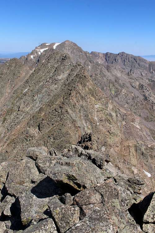
![Peak E from summit Peak F]() Peak E from summit Peak FOverview
Peak E from summit Peak FOverview
 Peak E from summit Peak F
The most enjoyable way to climb Peak E is by scrambling along the Ripsaw Ridge from Peak D to F - with Peak E being in the center of that ridge. Climbing along the Ripsaw Ridge is one of the most iconic routes in the Gore Range.
Getting There
Route Description
I recommend to do the traverse from Peak D to F and not the other way around. The basin below Peak D is a great place for an overnight camp with a creek to fill up your water supply. There is no option to camp higher up on Peak F and no water. Descending down the seeminly never ending talus fields of Peak F will want to make you cry, scrambling them up would be even more painful.
Start as early as possible to be off the ridge latest by noon. The gullys West of Peak E are offering several escape routes down to Piney Valley if a thunderstorm moves in.
Climb to the summit of Peak D. ROUTE - PEAK D
From here you have a great view of the portion of the Ripsaw Ridge to Peak E ( Peak F is hidden behind Peak E). You can stay most the time on the ridge, keeping it to max Class 4. Only the ascent after the first deep notch in the ridge must be bypassed on the East or West (less exposure). Any obstacle along the ridge can always be bypassed on the Western side if need be.The summit block of Peak E offers numerous scrambling routes to the top. The section from Peak E to F consists of a row of several gendarmes. They all can be either climbed over (max Class 4) or bypassed on the West. If you climb over the last gendarme right before the summit of Peak F (instead of bypassing it) : this requires an airy Class 3 downclimb to a small ledge leading to the summit block of Peak F. If you slip or trip on that climb down, not much will stop you from falling 30 ft down into the tallus field below.Getting to the summit of Peak F is an easy and quick Class 3 climb (it is a lot easier then it looks from the distance).
Essential Gear
Helmet is a must