
|
|
Mountain/Rock |
|---|---|
|
|
51.88380°N / 3.4372°W |
|
|
Hiking |
|
|
2906 ft / 886 m |
|
|
Overview
Pen Y Fan is the highest mountain in South Wales, in the middle of the Brecon Beacons. There are wonderful views across the valley of the river Usk to the North, and connecting walks from the summit to the other "Beacons". The easiest route is a walk, stiff at times, up the "back" of the mountain from the Storey Arms Visitor Centre (altitude 430m) on the A470 road from Brecon to Merthyr. The Storey Arms route took me about 1 hour to the summit in poor weather, walking briskly on the flatter bits. It attracts hordes of people in good weather, but it was cloudy and raining when I climbed, and there were no more than 20 people on the whole mountain. There are more challenging and worthwhile scrambles up the mountain from the North, which few people use, though the view is much more dramatic.
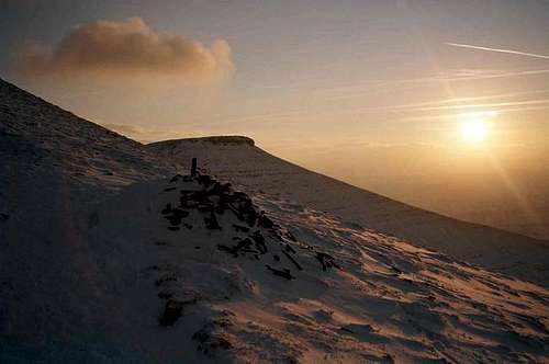
Cracking sunset
Getting There
M4 from London to Wales, then A40 to Brecon, finally turn South onto the A407 just West of Brecon. Storey Arms is well signposted, on the left with a good car park on the left.
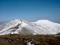
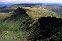
Corn Du and Pen Y Fan
Red Tape
No permits required. No fees. The mountain was closed to walkers after the foot and mouth epidemic in 2001, but is now open.
When To Climb
This is a mountain you can climb any time of year. The weather is marginally more reliable in summer than winter, but the mist can descend in Wales at any time. When the weather is clear the views from the top are fantastic, whether it's over snow or greenery.

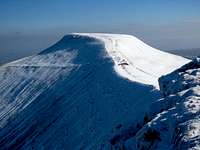
On the summit
Camping
There are lots of local camp sites in the Usk Valley to choose from. I would recommend just turning up and asking locally.
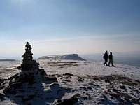
Summit cairn and hikers
Mountain Conditions
Some good websites on Pen Y Fan and the surrounding area:
Weather forecast
Local weather forecasts could help if you want to predict the conditions, but you can't depend on them. Its a good idea to have a compass and a good map just in case the mist comes down.
Brecon Beacons Park Society
A very informative site about Pen Y Fan and its surroundings.
White and green
 |
 |
Pen Y Fan and Cribyn, different seasons.
Distances to other climbs
The distance from Pen-y-Fan to:
Snowdon (143km)
Scafell Pike (289km)
Glencoe (542km)
Glenshee(552km)
Nevis Range (566km)
External Links
- A trip report illustrated with good photos
- A short trip report from the area
- Wales - 50 Most Prominent Peaks
- Photos of the Welsh wilderness