
|
|
Mountain/Rock |
|---|---|
|
|
37.36590°N / 118.7551°W |
|
|
Inyo County |
|
|
Mountaineering |
|
|
Spring, Summer, Fall |
|
|
12680 ft / 3865 m |
|
|
General Info
Peppermint Peak is the ignored and neglected, but spectacularly striped mountain just off of Bear Creek Spire’s eastern ridgeline in the John Muir Wilderness area of Inyo National Forest. The connection being at Spire Col, where the rock of each mountain are amazingly quite the contrast of the other and the ridgeline of the similarly tiger-striped Peak 12245 begins stretching eastward.
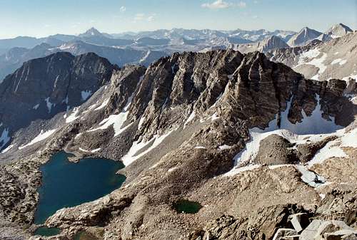
Lying directly east of Bear Creek Spire and directly south of Pyramid Peak, Peppermint Peak looks down onto an assortment of lakes - Spire, Split and Bear Lakes to the northeast, and Birchim Lake to the southeast. The view from atop, although not terribly aesthetic on the southern floorboard, is vast and quite pleasing in all directions.
Although seemingly inaccessible from nearly all flanks, except by way of 5th class technical climbing up the chute in Spire Col, the west ridge of this peak can be reasonably approached and ascended from the southern flank with moderate, but particular, Class 3 scrambling. It appears that poor Peppermint is most often by-passed for the more grand ascents of nearby neighbors Bear Creek Spire and Mt Julius Caesar.
Getting There
There are three trailheads appropriate for the approach to Peppermint Peak; Pine Creek and Morgan Pass trailheads near the pack station and adjacent tungsten mine, and Mosquito Flat trailhead in Little Lakes Valley. Pine Creek trail navigates the northern edge of Pine Lake, giving way to beautiful views of Mt Julius Caesar.
The best way to access Peppermint Peak if you are ascending via Spire Col from the north, is from the Mosquito Flat trailhead (10,200’) in Little Lakes Valley at the end of Rock Creek Road, which exits Hwy 395 in Tom’s Place north of Bishop. Plenty of overflow parking is available if you are not an early bird on the weekends. The trail begins at the southern end of the last parking lot and a “last chance” facility is available there. Be advised that Rock Creek road will close a few miles out from the trailhead during snow season at the SnoPark.
Map needed: Mt. Hilgard, CA and Mount Tom, CA 7.5 minute USGS
Red Tape
Peppermint Peak is within the boundaries of the John Muir Wilderness in the Inyo National Forest. Wilderness permits are required for overnight camping from May 1 through November 1, but not for day hikes. The Mosquito Flat trail is subject to quotas and bear canisters are required.Permit reservations may be obtained by calling (760)873-2483, or by writing to:
Inyo National Forest
351 Pacu Lane
Suite 200
Bishop, CA 93514
Permits can be picked at the following ranger station:
White Mountain Ranger Station
798 North Main Street
Bishop, CA 93514
(760)873-2500
Hours: 0800 - 1700
Open all year
Mon-Fri only in winter
Camping
Preferred camping is available at Pine Lake but can be done anywhere you're lucky enough to find a flat space near a water source. Birchim Lake would be another choice along the route and last chance for sandy beachfront property.Don't forget your permit!
Links
Mountain weather conditionsPack Station Info
Pine Creek Tungsten Mine