
Google (and other sources) usually point to the Karakoram Highway as the highest highway in the world, with its highpoint being the Khunjerab Pass at around 4,700 meters. It's Wikipedia entry covers its ass by calling it the highest "international highway."
But the Tibet Friendship Highway runs through two passes claimed to be over 5,000 meters and long sections are at over 4,000 meters. The Friendship Highway is just about completely paved now, so it would seem to be the winner.
Am I wrong? I guess I should cover my own ass by saying I'm referring to the highest highway, not highest paved pass or small stretch of road, in the world.
highest paved highway in the world?

-

Baarb - Posts: 408
- Joined: Tue Jun 06, 2006 6:42 pm
- Thanked: 43 times in 30 posts
Also see here: http://www.summitpost.org/mountain/rock ... raile.html
-

Bruno - Posts: 278
- Joined: Tue Oct 02, 2007 9:16 am
- Thanked: 112 times in 76 posts
Re: highest paved highway in the world?
Not sure how exactly we should define “Highway”, but by no means the Karakoram Highway is the highest paved highway. Here some precisions:
The Friendship Highway (road G318) has 3 actually passes over 5’000m in its stretch between Lhasa and the Nepal border. The altitude may vary considerably according to the maps, here below the GPS readings:
1) Gyatso La, altitude 5260m, located between Lhatse and Tingri (in some maps Gyatso La is mentioned as as Langpa La / Lagpa La / Lhakpa La / Maphu La), Lat28°57'06"N Lon 87°26'15"E
2) Lalung La, alt. 5025m, located between Tingri and Nyalam, Lat 28°36'50"N Lon 86°08'08.90"E
3) Thong La, altitude 5146m, located between Tingri and Nyalam (in some maps Thong La is mentioned as Yakri Shungla), Lat 28°30'59.20"N Lon 86°10'01.60"E
Correct, but the highest pass on the road at an altitude 5260m, Gyatso La, is paved since 2005 or 2006. So the recent paving in 2009 of the stretch between Tingri and the border (including Lalung La and Thong La) had no influence on the “highest paved highway” title.
By your definition of paved highway, yes the FH is probably is the highest since 2005-2006 (paving of Gyatso La), but the previous “winner” was not Khunjerab pass, neither other passes in the Andes. Tanggu La (also spelled Dang La or Tanggula Shankou) located on the Qinghai – Tibet Higway (road G109) is the highest pass on the road, with an altitude of 5230m. My guess is that this road is asphalted since a few decades, although I’m not sure since when exactly.
There are several unpaved highways with passes over 5400m, but the highest isn’t precisely on the Xinjiang – Tibet Highway (road G219 between Kargilik and Lhatse). The highest pass is actually Semo La, Lat 30°06'36.0"N Lon 85°25'54.1"E, with an altitude of 5565m. Semo La is located on road S206 between Raga and Gertse; road S206 may correspond to the definition of a highway, in the sense that it is the most transited road between Lhasa/Shigatse and Ali in western Tibet. My guess is that it will be asphalted over the next few years.
MichaelJ wrote:the Tibet Friendship Highway runs through two passes claimed to be over 5,000 meters
The Friendship Highway (road G318) has 3 actually passes over 5’000m in its stretch between Lhasa and the Nepal border. The altitude may vary considerably according to the maps, here below the GPS readings:
1) Gyatso La, altitude 5260m, located between Lhatse and Tingri (in some maps Gyatso La is mentioned as as Langpa La / Lagpa La / Lhakpa La / Maphu La), Lat28°57'06"N Lon 87°26'15"E
2) Lalung La, alt. 5025m, located between Tingri and Nyalam, Lat 28°36'50"N Lon 86°08'08.90"E
3) Thong La, altitude 5146m, located between Tingri and Nyalam (in some maps Thong La is mentioned as Yakri Shungla), Lat 28°30'59.20"N Lon 86°10'01.60"E
MichaelJ wrote:The Friendship Highway is just about completely paved now
Correct, but the highest pass on the road at an altitude 5260m, Gyatso La, is paved since 2005 or 2006. So the recent paving in 2009 of the stretch between Tingri and the border (including Lalung La and Thong La) had no influence on the “highest paved highway” title.
MichaelJ wrote:so it would seem to be the winner
By your definition of paved highway, yes the FH is probably is the highest since 2005-2006 (paving of Gyatso La), but the previous “winner” was not Khunjerab pass, neither other passes in the Andes. Tanggu La (also spelled Dang La or Tanggula Shankou) located on the Qinghai – Tibet Higway (road G109) is the highest pass on the road, with an altitude of 5230m. My guess is that this road is asphalted since a few decades, although I’m not sure since when exactly.
butitsadryheat wrote:Corax's page on the front page talks of roads over 5400m. The Xinjiang Highway (same?).
There are several unpaved highways with passes over 5400m, but the highest isn’t precisely on the Xinjiang – Tibet Highway (road G219 between Kargilik and Lhatse). The highest pass is actually Semo La, Lat 30°06'36.0"N Lon 85°25'54.1"E, with an altitude of 5565m. Semo La is located on road S206 between Raga and Gertse; road S206 may correspond to the definition of a highway, in the sense that it is the most transited road between Lhasa/Shigatse and Ali in western Tibet. My guess is that it will be asphalted over the next few years.
-

Scott - Forum Moderator
- Posts: 8550
- Joined: Thu Aug 21, 2003 1:03 pm
- Thanked: 1212 times in 650 posts
Paved highways:
The highway between La Paz Bolivia and Arica Chile was paved some years ago. It's highpoint is supposedly 5030 meters (~16,500 feet). I don't know the elevations of the ones in NW China China and Pakistan. They may be higher (see post above).
What about the road to the North Everest Base Camp? Didn't China pave that one for the Olympics? If so, that would put it at 5360 meters (17,590 feet). I don't know if it would be considered to be a highway though.
Unpaved highways/roads:
Supposedly, the new main road between Adagua Peru and Arequipa reaches 5500 meters (18,000+ feet) east of Coropuna, but the road isn't on any maps, so this is hard to verify and looking at the map, personally I am somewhat skeptical. Unfortunately as well, buses only run at night, so I couldn't follow the map accurately by starlight.
Aucanquilcha Bolivia has the highest unpaved road that I know of. The road reaches 6050 meters (19,849 feet), but since the mine near the summit closed, rockslides have blocked the road at 5500 meters (18,044 feet), but some people still mountain bike it!
If interested, that one isn't even the highest in Colorado, nor is it paved. Mount Evans has the highest paved road in Colorado. The mining roads on Mount Lincoln and Mount Bross are also higher than the one on Pikes.
The highway between La Paz Bolivia and Arica Chile was paved some years ago. It's highpoint is supposedly 5030 meters (~16,500 feet). I don't know the elevations of the ones in NW China China and Pakistan. They may be higher (see post above).
What about the road to the North Everest Base Camp? Didn't China pave that one for the Olympics? If so, that would put it at 5360 meters (17,590 feet). I don't know if it would be considered to be a highway though.
Unpaved highways/roads:
Supposedly, the new main road between Adagua Peru and Arequipa reaches 5500 meters (18,000+ feet) east of Coropuna, but the road isn't on any maps, so this is hard to verify and looking at the map, personally I am somewhat skeptical. Unfortunately as well, buses only run at night, so I couldn't follow the map accurately by starlight.
Aucanquilcha Bolivia has the highest unpaved road that I know of. The road reaches 6050 meters (19,849 feet), but since the mine near the summit closed, rockslides have blocked the road at 5500 meters (18,044 feet), but some people still mountain bike it!
Pike's Peak?
If interested, that one isn't even the highest in Colorado, nor is it paved. Mount Evans has the highest paved road in Colorado. The mining roads on Mount Lincoln and Mount Bross are also higher than the one on Pikes.
-

jrbrenvt - Posts: 34
- Joined: Wed Jun 17, 2009 6:16 pm
- Thanked: 2 times in 1 post

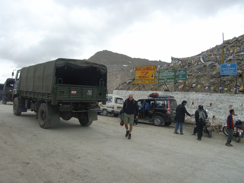
If this sign were correct this might be it. I would call it more of a road then a "highway" though. It was paved from what I recall (it was 2007 when I was there). Not to mention everyone in my group who had an altimeter were reading in the mid 17K's... But fun sign nonetheless. The altimeter readings seem to be backed up by the wikipedia page for Khardung La. I am quite sure this road exists for Indian military purposes but tourists make use of it as well.
-
Baarb - Posts: 408
- Joined: Tue Jun 06, 2006 6:42 pm
- Thanked: 43 times in 30 posts
peladoboton wrote:the highway that runs from northern chile over into boliva is well over 4500 and goes by parinacota, pomperape, and cerrop samja, all peaks i have visited but never had the dang time to climb!!!
The frontier on this road is round about 4530 m according to the GPS I pulled out there a couple of weeks back and the road doesn't really get much higher on either side. But given the other stronger contenders mentioned it's not really an issue I suppose.


-

Diego Sahagún - Posts: 14465
- Joined: Sun Oct 07, 2001 6:21 pm
- Thanked: 748 times in 682 posts
butitsadryheat wrote:Diego Sahagún wrote:That's not a paved highway (?)He wrote:I'm referring to the highest highway, not highest paved pass or small stretch of road, in the world.
Change the thread title then
-

mrchad9 - Posts: 4545
- Joined: Thu Jul 02, 2009 12:01 am
- Thanked: 1338 times in 911 posts
Diego Sahagún wrote:butitsadryheat wrote:Diego Sahagún wrote:That's not a paved highway (?)He wrote:I'm referring to the highest highway, not highest paved pass or small stretch of road, in the world.
Change the thread title then
Agree w Diego. Seems to be about highest paved highway. And the last sentence is saying that just bc it's paved isn't enough, it still needs to be a highway.
-

John Duffield - Posts: 2461
- Joined: Thu Oct 06, 2005 12:48 pm
- Thanked: 2516 times in 1399 posts
jrbrenvt wrote:
If this sign were correct this might be it. I would call it more of a road then a "highway" though. It was paved from what I recall (it was 2007 when I was there). Not to mention everyone in my group who had an altimeter were reading in the mid 17K's... But fun sign nonetheless. The altimeter readings seem to be backed up by the wikipedia page for Khardung La. I am quite sure this road exists for Indian military purposes but tourists make use of it as well.
+1
Here's a photo I lensed last year in the Khardung La. You can see an Indian military convoy moving through it. Kickass bike descent. Over 5600 meters.
-
- Related topics
- Replies
- Views
- Last post
-
- Highest cities of the world
by PAROFES » Fri Mar 30, 2012 8:33 pm - 1 Replies
- 2376 Views
- Last post by youngclimer123

Sat Apr 14, 2012 5:25 pm
- Highest cities of the world
-
- Oh Eun-sun Becomes 1st Woman to Conquer World's 14 Highest
by visentin » Tue Apr 27, 2010 3:45 pm - 10 Replies
- 4552 Views
- Last post by Damien Gildea
Sat May 01, 2010 3:28 am
- Oh Eun-sun Becomes 1st Woman to Conquer World's 14 Highest
-
- Four of the five highest mountains in one panoramic.
by thespiffy » Thu Dec 30, 2010 5:04 pm - 3 Replies
- 3446 Views
- Last post by radson
Thu Dec 30, 2010 6:39 pm
- Four of the five highest mountains in one panoramic.
-
- The Seven Highest Mountains on the Seven Largest Islands
by Cy Kaicener » Fri Nov 16, 2007 1:56 pm - 13 Replies
- 5508 Views
- Last post by Cy Kaicener
Sat May 01, 2010 5:44 pm
- The Seven Highest Mountains on the Seven Largest Islands
Who is online
Users browsing this forum: Google [Bot] and 0 guests