East side snow levels?
-

Luciano136 - Posts: 3778
- Joined: Thu Jan 19, 2006 11:46 pm
- Thanked: 11 times in 10 posts
East side snow levels?
Been out of the loop for a while. What are roughly the snow levels these days? University Peak area for example.
-

H2SO4 - Posts: 82
- Joined: Fri Feb 25, 2005 1:14 pm
- Thanked: 4 times in 3 posts
Re: East side snow levels?
Generally snowy above 10K, generally clear below 9K. Obviously a lot of variability with local topography.
-

fossana - Posts: 1013
- Joined: Fri Sep 26, 2003 9:31 pm
- Thanked: 41 times in 32 posts
Re: East side snow levels?
Lake Sabrina (elev 9138 ft) & environs from Cardinal Pinnacle as of 20 May 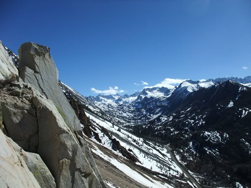
-

The Chief - Thanked: time in post
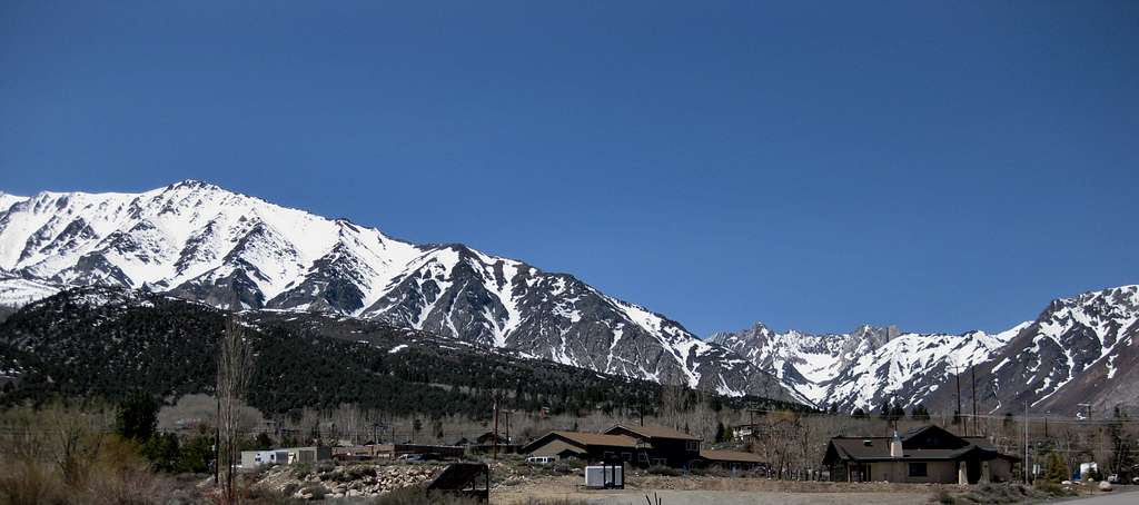
Re: East side snow levels?
From my front yard this afternoon (8.5-9K or so):
-
powderjunkie - Posts: 119
- Joined: Wed Oct 15, 2003 5:00 pm
- Thanked: 19 times in 16 posts
Re: East side snow levels?
Onion Valley TH has continuous snow from the lot to University col and a very short dirt hike going towards the north side of University.
deep snowpack overall
deep snowpack overall
-

Greg Enright - Posts: 556
- Joined: Thu Sep 04, 2003 2:16 am
- Thanked: 54 times in 38 posts
Re: East side snow levels?
McGee Canyon is all snow above 8800 feet. That is just below the large beaver pond. Trail crews are working to clean up the trees that were swept across the trail by avalanches this winter. Still can't see if the bridge got swept away, because the snow is so deep.
The campground is all dry though, and the campsites at the trailhead are all clear. Many of the streamside Alders and Willows were flattened by the heavy snow, and the Cottonwoods lost a lot of branches.
The campground is all dry though, and the campsites at the trailhead are all clear. Many of the streamside Alders and Willows were flattened by the heavy snow, and the Cottonwoods lost a lot of branches.
-
Luciano136 - Posts: 3778
- Joined: Thu Jan 19, 2006 11:46 pm
- Thanked: 11 times in 10 posts
Re: East side snow levels?
Thanks for the info! That gives a good general idea.
-
powderjunkie - Posts: 119
- Joined: Wed Oct 15, 2003 5:00 pm
- Thanked: 19 times in 16 posts
Re: East side snow levels?
anyone know where the snowline is approximately at Onion Valley or South Lake.
How much dry hiking up towards Kearsarge Pass?
thx
How much dry hiking up towards Kearsarge Pass?
thx
-

96avs01 - Posts: 1561
- Joined: Thu Nov 10, 2005 6:31 pm
- Thanked: 59 times in 47 posts
Re: East side snow levels?
powderjunkie wrote:anyone know where the snowline is approximately at Onion Valley or South Lake.
How much dry hiking up towards Kearsarge Pass?
thx
Yo D,
There was a lot of snow on the Bishop Pass trail last week only about 1/2 mile from trailhead. Have pics from top of Hurd if you want beta on anything specific.
Cheers
-

letzkov - Posts: 6
- Joined: Sat Dec 01, 2007 10:45 pm
- Thanked: 0 time in 0 post
Re: East side snow levels?
Hi, does anyone have an update on the snow conditions in the Matterhorn Peak area? Thanks
-

Carbo - Posts: 1601
- Joined: Wed Mar 03, 2004 8:43 pm
- Thanked: 8 times in 8 posts
Re: East side snow levels?
powderjunkie wrote:anyone know where the snowline is approximately at Onion Valley or South Lake.
How much dry hiking up towards Kearsarge Pass?
thx
Just hiked up that way last weekend. You will encounter snow already on the way to the first lake.
-
Luciano136 - Posts: 3778
- Joined: Thu Jan 19, 2006 11:46 pm
- Thanked: 11 times in 10 posts
Re: East side snow levels?
Carbo wrote:powderjunkie wrote:anyone know where the snowline is approximately at Onion Valley or South Lake.
How much dry hiking up towards Kearsarge Pass?
thx
Just hiked up that way last weekend. You will encounter snow already on the way to the first lake.
Any updates on the Kearsarge Pass trail? I imagine a decent amount of snow has melted in the meantime? Thinking about a jaunt up Gould this weekend.
-

Dizzy - Posts: 7
- Joined: Mon Aug 23, 2010 6:34 pm
- Thanked: 7 times in 3 posts
Re: East side snow levels?
Kearsarge Pass trail is snow free up to Gilbert lake, then its mostly snow covered. Both Heart and Big Pothole lakes are still frozen. I was there yesterday. Here is couple pictures:
https://picasaweb.google.com/alexey.gagarin/KearsargePass?authkey=Gv1sRgCM7IgJTX2pGW-gE&feat=directlink
https://picasaweb.google.com/alexey.gagarin/KearsargePass?authkey=Gv1sRgCM7IgJTX2pGW-gE&feat=directlink
-
Luciano136 - Posts: 3778
- Joined: Thu Jan 19, 2006 11:46 pm
- Thanked: 11 times in 10 posts
Re: East side snow levels?
Sweet! Looks like a good boot track to the pass. Do you recall if the rocks on the climber's right up to Mt. Gould were snow free? I would imagine so.
Dizzy wrote:Kearsarge Pass trail is snow free up to Gilbert lake, then its mostly snow covered. Both Heart and Big Pothole lakes are still frozen. I was there yesterday. Here is couple pictures:
https://picasaweb.google.com/alexey.gagarin/KearsargePass?authkey=Gv1sRgCM7IgJTX2pGW-gE&feat=directlink
-
olegace - Posts: 3
- Joined: Mon Jun 27, 2011 11:26 pm
- Thanked: 0 time in 0 post
Re: East side snow levels?
Anybody knows what's going on at Mosquito Flat / Little Lakes Valley? Is it possible to do some backpacking without snow gear?
-
- Related topics
- Replies
- Views
- Last post
-
- West side snow levels?
by Miroslava » Mon Jun 27, 2011 7:25 pm - 2 Replies
- 1507 Views
- Last post by Matthew Holliman

Tue Jun 28, 2011 3:03 pm
- West side snow levels?
-
- East side snow condtions?
by Luciano136 » Fri Oct 23, 2009 11:56 pm - 8 Replies
- 2755 Views
- Last post by Luciano136
Tue Oct 27, 2009 9:09 pm
- East side snow condtions?
-
- Saddlebag Lakes snow levels?
by The Defiant One » Thu Jul 20, 2017 12:23 am - 0 Replies
- 2164 Views
- Last post by The Defiant One
Thu Jul 20, 2017 12:23 am
- Saddlebag Lakes snow levels?
-
- Snow levels on Mount Shasta
1, 2by sfgfan10 » Mon Jul 15, 2013 10:28 am - 19 Replies
- 9600 Views
- Last post by sfgfan10
Wed Jul 17, 2013 1:47 am
- Snow levels on Mount Shasta
-
- Yosemite Valley south rim snow levels
by Noondueler » Fri Jun 25, 2010 1:05 am - 2 Replies
- 1936 Views
- Last post by jspeigl
Fri Jun 25, 2010 6:30 pm
- Yosemite Valley south rim snow levels
Who is online
Users browsing this forum: No registered users and 0 guests