Heading up Rush Creek trail from Silver Lake to Thousand Islands lake (elev 10K) this weekend. Does any know at what level I can expect significant snow, if at all, before Thousand Islands lake?
I don't recall any serious stream crossings last time I was there, but if there are any treacherous ones due to high runoff, I'd appreciate that intel too.
Cheers!
Ritter Range Conditions??
8 posts
Page 1 of 1
-

96avs01 - Posts: 1561
- Joined: Thu Nov 10, 2005 6:31 pm
- Thanked: 59 times in 47 posts
Re: Ritter Range Conditions??
1000 Island is about 1/2 melted out (as of Saturday). We hit snow on the trail to Ediza above 9K, and continuous snow above the lake.
-

Trawinski - Posts: 70
- Joined: Tue May 31, 2011 3:47 pm
- Thanked: 7 times in 6 posts
Re: Ritter Range Conditions??
If anyone's interested: I just spoke with the ranger at Lee Vining. Rush Creek trail up to Spooky Meadow is all melted out, then there's 20-30% coverage from there to Thousand Islands Lake. Thousand Isle area has 50% snow coverage.
(I've seen Rangers be WAY off before though, so take that with a grain of salt.)
(I've seen Rangers be WAY off before though, so take that with a grain of salt.)
-

markv - Posts: 189
- Joined: Sun May 30, 2004 5:16 am
- Thanked: 3 times in 3 posts
Re: Ritter Range Conditions??
I came out a few miles south of there today, and it's melting fast. I'd expect less snow than the above report.
-

jspeigl - Posts: 182
- Joined: Thu Dec 04, 2008 6:13 am
- Thanked: 5 times in 5 posts
Re: Ritter Range Conditions??
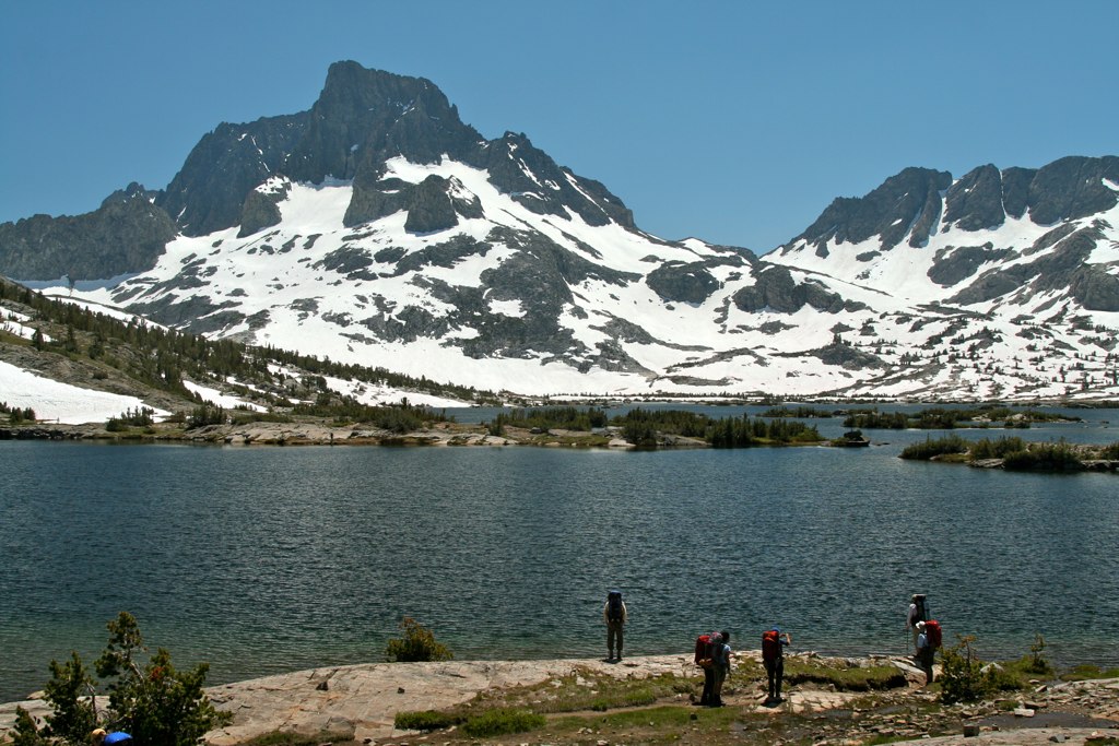
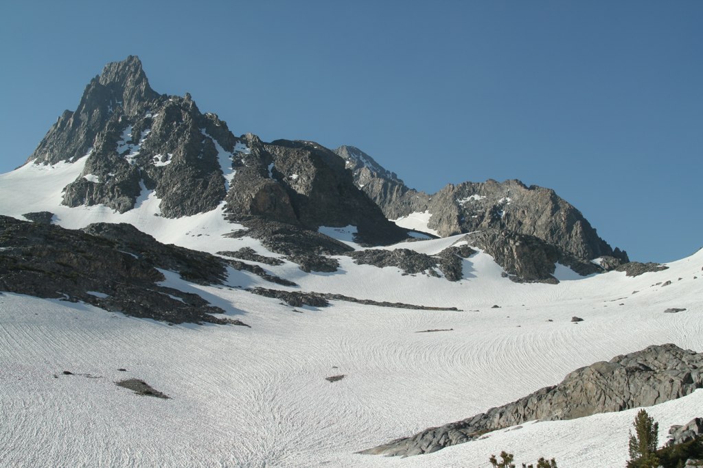
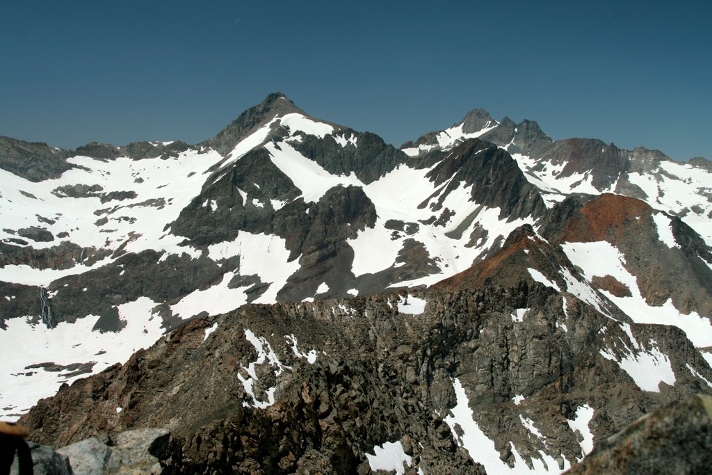
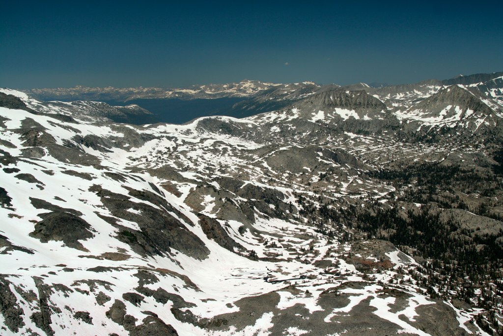
I happened to be up at Thousand Island Lake this weekend (7/22 - 7/24). Here are some pictures:
TIL and Banner Peak:
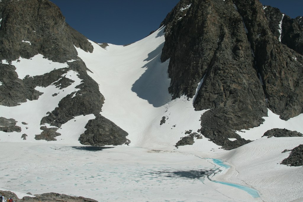
North Glacier Pass near Banner Peak:
Rogers Peak and Lyell (I think) from the top of Davis Peak.:
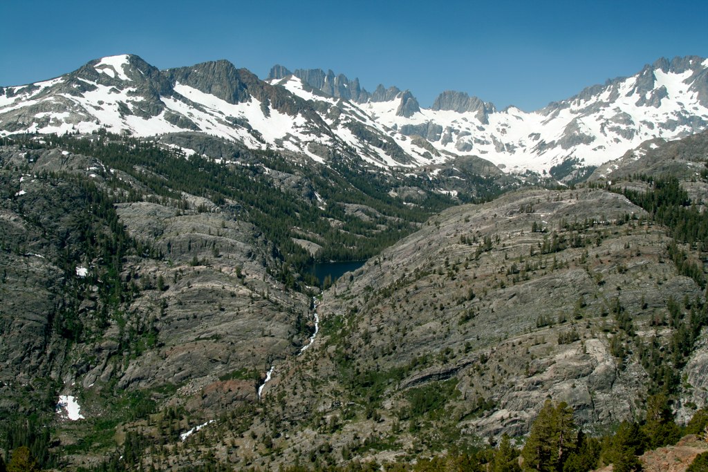
Donahue Pass towards Lyell Creek and Tuolumne meadows:
The canyon west of Mt. Davis. Note the huge snow bridge that must be 20 feet high:
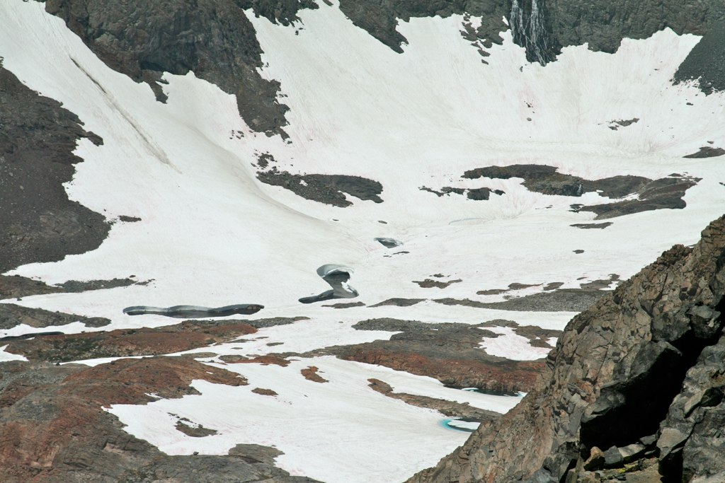
The glacier to the Banner-Ritter saddle north side and lake Catherine:
Shadow Lake and part of the minarets:
TIL and Banner Peak:
North Glacier Pass near Banner Peak:
Rogers Peak and Lyell (I think) from the top of Davis Peak.:
Donahue Pass towards Lyell Creek and Tuolumne meadows:
The canyon west of Mt. Davis. Note the huge snow bridge that must be 20 feet high:
The glacier to the Banner-Ritter saddle north side and lake Catherine:
Shadow Lake and part of the minarets:
-

dskoon - Posts: 3122
- Joined: Thu Nov 13, 2008 2:06 am
- Thanked: 136 times in 104 posts
Re: Ritter Range Conditions??
Nice pics, Jspeigl. Makes me want to do a rocket run down. . .
-

artrock23 - Posts: 144
- Joined: Thu Jul 28, 2011 4:26 pm
- Thanked: 691 times in 385 posts
Re: Ritter Range Conditions??
Wow... great photos!
I'm hoping to do Cecile Lake from Agnew Meadows in a few weeks.
I'm hoping to do Cecile Lake from Agnew Meadows in a few weeks.
-
Byran - Posts: 12
- Joined: Thu Mar 04, 2010 5:23 am
- Thanked: 2 times in 2 posts
Re: Ritter Range Conditions??
We just got back yesterday from a trip to Clyde Minaret. The approach from Reds Meadows to Minaret Lakes is free of snow. From Minaret Lake to Cecile Lake is patches of snow. The approach from Cecile Lake to the base of Clyde was almost completely snow covered, except for a few spots of cliffs and talus poking out.
The snow was frozen solid at 7am but softened by mid morning and remained soft into the evening (we were still descending the snow field at 7pm and the conditions were good). We descended the Ken-Clyde couloir which is free of snow for the top 2/3rds and filled with snow below the rappel at the giant chockstone. We had to do a couple extra raps below this point to avoid some 45 degree snow*. These rappels were a pain in the ass and time consuming. After the gully widens and the snow becomes less steep there is a somewhat scary section of step kicking down 30 degree snow*. Gloves and a very small and basic self-arrest tool (like a big, fat tent stake) would be ideal. We had pointy rocks. If you were to carry ice axes on the climb you could probably glissade the whole couloir without the extra rappels.
The mosquito presence in the area ranges from mild to severe depending on your location and the time of day.
---------
* I'm not very good at judging the angle of snow, so take these measurements with a grain of salt.
----
Edited to add some photos
- Approaching Clyde Minaret
- DSCN3965.JPG (252.27 KiB) Viewed 3150 times
- A view of Ritter and Banner from near the summit of Clyde
- DSCN3968.JPG (289.07 KiB) Viewed 3150 times
- Descending from Clyde Minaret
- DSCN3983.JPG (236.71 KiB) Viewed 3150 times
- Not really a "conditions" photo, but Riegelhuth Minaret from Cecile Lake
- DSCN3985.JPG (64 KiB) Viewed 3150 times
8 posts
Page 1 of 1
-
- Related topics
- Replies
- Views
- Last post
-
- Minarets/Ritter Conditions
by sharperblue » Thu Oct 14, 2010 3:32 am - 3 Replies
- 2055 Views
- Last post by sharperblue

Thu Oct 14, 2010 4:01 pm
- Minarets/Ritter Conditions
-
- Mount Ritter Conditions?
by smorlock » Sat Sep 03, 2016 2:11 am - 11 Replies
- 4050 Views
- Last post by Simkin
Fri Oct 14, 2016 7:48 pm
- Mount Ritter Conditions?
-
- Ritter Banner Conditions
by OOG » Wed Jun 25, 2014 2:50 am - 5 Replies
- 2988 Views
- Last post by Marmaduke
Fri Jul 04, 2014 6:48 am
- Ritter Banner Conditions
-
- Ritter/Banner conditions
by Luke Swanson » Thu Jul 23, 2015 6:19 am - 2 Replies
- 2105 Views
- Last post by hgrapid
Wed Jul 29, 2015 6:57 pm
- Ritter/Banner conditions
-
- Ritter SE glacier conditions?
by SpazzyMcgee » Wed Sep 16, 2009 7:42 pm - 7 Replies
- 2308 Views
- Last post by SpazzyMcgee
Thu Sep 24, 2009 2:19 am
- Ritter SE glacier conditions?
Who is online
Users browsing this forum: No registered users and 0 guests