
-
 14636 Hits
-
 89.39% Score
-
 29 Votes
|
|
Mountain/Rock |
|---|---|
|
|
28.69260°N / 17.877°W |
|
|
6049 ft / 1844 m |
|
|
Overview
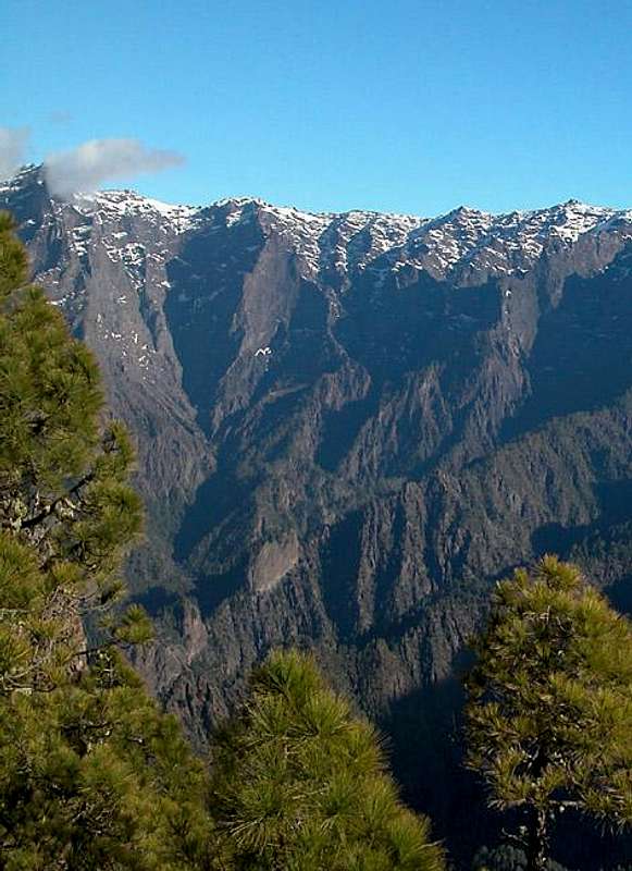
 Pico Bejenado (1844m) seen through one of the gullies beneath Pared de Roberto Pico Bejenado (1844m) seen through one of the gullies beneath Pared de Roberto |
With 1844m Pico Bejenado certainly is not one of the highest summits of La Palma but due to its solitary location it is often dubbed as the “only mountain" of the island. Though part of the Caldera de Taburiente and located on the crater’s southern crest Pico Bejenado is utterly different from the higher rim summits like Roque de los Muchachos, Piedra Llana, Pico de la Nieve or Punta de los Roques. It is separated from the remainder of the Caldera by the deep Cumbrecita Saddle and thus stands out from its surroundings by more than 500m on all sides.
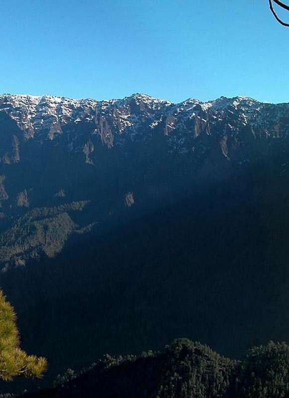
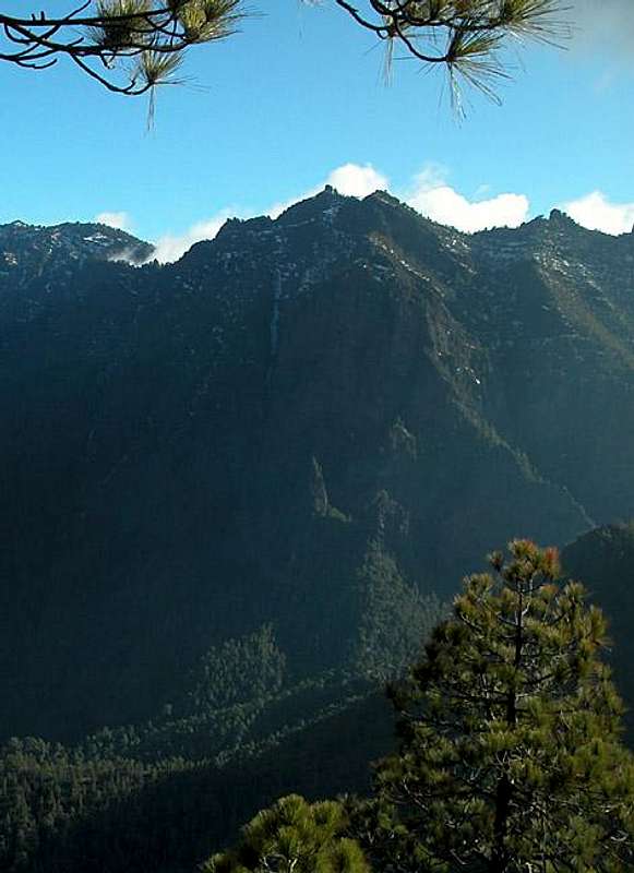
The most impressive face of Bejenado is its north face which drops down into the caldera by some 800-900m. The face is structured in massive steps as well as deep gullies and seen from the inside of Caldera de Taburiente it is truly awe inspiring. But the west and east faces also show these wild vertical steps so that the south face is the only reasonable choice of route for ascending the mountain. However, the south face is much steeper than the outside faces of the other caldera summits and also covers an elevation difference of up to 800m.
 |  |  |
There are two routes onto Pico Bejenado. Both start from the same trailhead close to the Cumbrecita Saddle. While one traverses the south slopes in various zigzagging turns the other runs very close to the caldera crest and thus offers perfect views. Both routes recombine at the El Rodeo Saddle to the east of the summit block and climb the summit from its southern side. The summit itself is a smaller rock on a football field sized plateau. You will encounter exposure only on the edges of this summit plain but there it can become breathtaking. I explored the summit for a while and can assure you that on the north side it suddenly gets very vertical.
 |  |  |
Being a solitary mountain, Pico Bejenado is one of the best viewpoints on the whole island of La Palma. Only Pico Birigoyo on the other side of the broad Aridane Valley can match the views but the characters of both summits and their views are completely different. Birigoyo is part of the Cumbre Vieja range and impresses with its faraway views of the Caldera de Taburiente and neighbouring Tenerife while Bejenado excels in the reverse view towards Cumbre Vieja and a close-up on (and in) the Caldera. Just have a look at the panorama below and you will get a notion of what awaits you there. The views deep into the crater cannot be captured on film (or chip) correctly and nothing beats the original experience.
 |  |  |
On the south slopes of Pico Bejenado, close to the trailhead at El Barrial there are two archaeologically interesting sites of rock drawings which date back to the original Canarian inhabitants, the Guanches. Their culture was at the stone age stage when the Spaniards started their conquest of the Canarias and after the fall of their last strongholds on Gran Canaria and La Palma the whole people - or rather their culture - became extinct. The only leftovers of that time are the mysterious rock drawings - circles and spirals, often to be found near the rare running water. The Spanish conquest was so complete that today almost nothing is known about these original Canarians.
Panoramic view
Pico CorralejoPunta de los RoquesRoques de la CumbrecitaPiedras del CadrePicos de la Veta de la ArenaPico de la SabinaPico de la NievePico de la CruzPiedra LlanaPico de la CruzPico del AtaùdRoque de los MuchachosPico de la Fuente Nueva
 |  |  |
North-eastern part of the Caldera de Taburiente as seen from just below the Pico Bejenado summit on Feb 22nd 2004. Hide / Show Annotations
Some words on the Caldera de Taburiente: it is one of the world’s largest erosion crater with 29km in circumference, 9km in diameter and up to 1500m of vertical faces on its inside. As is typical for an erosion crater the caldera is in constant decay with large mud- and landslides occurring in the winter months. The debris is taken care of by a network of creeks which combine in the Canarias’ only river, Rio de Taburiente. The latter has carved a deep gorge into the southwestern part of the Caldera, the Barranco de las Angustias. The latter runs directly to the north of Pico Bejenado’s north face.
Getting There
  |
La Palma, like all the other Canary Islands can easily be reached from almost all major European airports. The airport is rather small and compared to Tenerife or Gran Canaria air trafic is rather low. There are almost no regular flights but all year round you'll be able to book charter flights.
 |  |  |
El Barrial Trailhead
There is only one reasonable trailhead close to the Cumbrecita Saddle, called El Barrial. To reach it, follow LP-1 north from the airport until you reach the first roundabout. Here turn westward on LP-2 which leads you through the Cumbre Nueva Tunnel to the western side of the island. Shortly after the tunnel LP-202 turns off to the right (north) - there is the Caldera de Taburiente Information Centre at the intersection. Follow LP-202 which would lead you straight to the Cumbrecita Saddle. After 500m a road to the right leads to Ermita de la Virgen del Pino, after another 500m the El Barrial road turns off to the left. This is a very rugged road - depending on the car you drive you might want to hike it. The additional hiking time is roughly one hour.
Red Tape
 Pico Bejenado in front of the western Caldera de Taburiente
The Caldera de Taburiente has been declared national park (Parque Nacional de la Caldera de Taburiente), which was created in 1954 and which consists of an area of 4690ha. From the trailhead at El Barrial you are on park territory so follow the rules. Nothing outrageous but camping is not permitted as well as leaving the prepared trails. Be sure not to drive farther than El Barrial. The rock drawings mentioned above have been vandalized in former times so that now they are secured by "heavy armor". San Quentin cannot have thicker bars than you find here.
When To Climb
Pico Bejenado can be climbed all year. We found patches of snow along the northern and eastern faces but nothing serious. No special equipment is needed.Accommodation
Camping is a bit of a problem on La Palma. There are some official campgrounds in the north but the one near Los Canarios is still a project. There are, however, a couple of "Zonas Recreativas" where sometimes you are allowed to pitch a tent. For the caldera this would be right at the centre at Playa de Taburiente for which you have to obtain a one day permit beforehand. It can be obtained at the visitor's center at the intersection of LP-2 and LP-202 (see Getting there for the Cumbrecita Trailhead).Other accommodation is no problem. Every European travel office will be able to book hotels, rooms and apartments for you. I won't include any links here because all of them definitely are commercial. Another option is to rent a finca (rural house) from the owners directly. You'll have to google for these but sometimes prices are low enough for the scheme to be worthwhile.
Weather Conditions
Usually all year round the Canarias have the same weather with little alterations: north-eastern trade winds which deposit fog and dew on the north-eastern slopes of the islands. The eastern and southern parts usually are very dry and there you'll get some hours of sunshine each day. Especially on the higher islands like La Palma you usually don't have to worry about weather too much. The mountaintops will stick out of the clouds.
There are no reliable weather forecasts for the mountain regions of La Palma. Often a cloudless day turns into a foggy one within half an hour. Especially the Cumbre Vieja Range is prone to these fogs and here orientation among the lava and scree fields gets very difficult. This is the main reason why you should never leave the trails there.
Forecasts for the coastal regions, however are available. You have to subtract 1°C for every 100m of altitude so that Roque de los Muchachos will still be near freezing when the coasts have already fine and sunny beach weather. The following table gives a little overview about the average weather data of the capital of Santa Cruz:
| Month | Jan | Feb | Mar | Apr | May | Jun | Jul | Aug | Sep | Oct | Nov | Dec |
| Avg. day temp.[°C / °F] | 21 / 70 | 21 / 70 | 22 / 72 | 22 / 72 | 22 / 72 | 24 / 75 | 25 / 77 | 26 / 79 | 26 / 79 | 26 / 79 | 24 / 75 | 22 / 72 |
| Avg. night temp.[°C / °F] | 15 / 59 | 14 / 57 | 15 / 59 | 16 / 61 | 17 / 63 | 18 / 64 | 19 / 66 | 21 / 70 | 21 / 70 | 19 / 66 | 18 / 64 | 16 / 61 |
| Water temp.[°C / °F] | 19 / 66 | 18 / 64 | 19 / 66 | 19 / 66 | 19 / 66 | 20 / 68 | 22 / 72 | 23 / 73 | 22 / 72 | 22 / 72 | 21 / 70 | 20 / 68 |
| Sunny Hours / Day | 5 | 6 | 6 | 7 | 8 | 9 | 10 | 9 | 8 | 6 | 5 | 5 |
Maps & Books
- La Palma
1:30000
Edition Freytag & Berndt
ISBN: 3-7079-0346-X
The guidebook I used is every bit as good as the map with excellent tour descriptions. It is available in English as well but I am not sure about the quality of the translation.
- LaPalma
A. and W. Wolfsperger
Rother Verlag
ISBN:
3-7633-4246-X (German)
3-7633-4808-5 (English)