
-
 13761 Hits
-
 89.39% Score
-
 29 Votes
|
|
Mountain/Rock |
|---|---|
|
|
28.58300°N / 17.8336°W |
|
|
Hiking |
|
|
Spring, Summer, Fall, Winter |
|
|
6305 ft / 1922 m |
|
|
Overview
 Crater del Hoyo Negro Crater del Hoyo Negro |
Among the 120 volcanoes and craters of the Cumbre Vieja Mountain Range both Pico Nambroque and its western crater, Cráter del Hoyo Negro are unique. Pico Nambroque is with its 1922m elevation the second highest summit of the Cumbre Vieja Range, only beaten by the two summits (both!) of the slightly higher Volcán de la Deseada. Moreover Pico Nambroque is the only Cumbre Vieja mountain which displays any rocky features. While all the others are cinder cones or consist of sintered scree, Nambroque is a solid basalt structure (surrounded by cinder). Also, there are deep funnels which lead right into the heart of the mountain. Dropping a stone didn't yield measurable results but it kept falling and rolling for about 20s. It is therefore reasonable to assume that Nambroque is located on top of the very heart of the Cumbre Vieja Volcano.
Those of you who have followed my La Palma postings will know about the megatsunami theory, according to which the western half of Cumbre Vieja will slide into the sea with devastating effects on all coastlines of the northern Atlantic. Part of the reasoning for this theory stems from exactly these funnels. There are quite a number of them all around the central part of the Cumbre Vieja Range and measurements have shown that they are filled with water at their core. Now imagine what happens when in the course of an eruption the hot magma hits the water: explosions which rock the whole range will occur and make that landslide scenario all the more probable (more on the theory in the next section, also see the link to the scientific paper which explains the theory with figures).
 |  |  |
Similar to neighbouring Montaña del Fraile, Pico Nambroque is better known for its crater, Cráter del Hoyo Negro, a giant black hole (-> the name) on the western side of the summit. Hoyo Negro was one of the three volcanoes which broke out simultaneously in 1949 in three devastating eruptions. The other two were Cráter del Duraznero and Volcán de San Juan. Together the three eruptions resulted in a massive crack in the Cumbre Vieja Range, with the western part dropping up to 4m downwards. This crack can still be seen when trekking the Ruta de los Volcanes trekking trail.
 |  |  |
Both Pico Nambroque and Cráter del Hoyo Negro are very popular among the hikers on La Palma. They are located at the centre of the Cumbre Vieja Range and can be reached by four routes. The most popular ones are the two legs of the Ruta de los Volcanes trekking trail, a must see for any La Palma visitor (it'll come up as a route to Volcán de la Deseada in a couple of days). While the trail touches the eastern rim of Hoyo Negro, Pico Nambroque is located a little to the east, hidden behind a pine forest. That makes it a rather solitary and enjoyable place (for La Palma).
Geography of La Palma and the Mega-Tsunami Theory
 One of the funnels which lead deep into the Cumbre Vieja
Geography
La Palma, like said above and like all the other Canary Islands is of volcanic origin. Actually you can draw a pretty accurate comparison to the Hawaiian Islands since both groups are similar in many respects. The Canarias have been formed 25 - 2 million years ago with La Palma one of the youngest islands together with tiny El Hierro. What strikes us most today is that the ocean floor around and between the islands is about 4000m deep, which makes mighty Teide (3718m) on Tenerife a truly impressive mountain if you consider the elevation from the ocean floor.
La Palma is not quite as impressive but it is the second highest of the Canarias with its highpoint, Roque de los Muchachos at 2426m. On the other hand it is the third smallest of the islands and thus the ratio of overall material to island area is the largest you will find for any island on earth. This makes it the prime candidate for causing the next mega-tsunami (see below).
The Island can be divided in three mountainous regions:
- the Caldera de Taburiente in the north, the world's largest erosion crater with a diameter of 29km and with caldera walls up to 2000m deep! The caldera is the leftover of a huge volcano which used to exist ages ago and which collapsed by sliding to the west of the island 550.000 years ago.
- the Cumbre Nueva, also the leftover of an even larger volcano. This Volcano also dropped away to the west of the island.
- the Cumbre Vieja. Though viejo means old, this is the youngest part of the island by far. Here you can find 120 volcanoes, all very close to each other on this mountain range, which reaches 1945m in height. It is here that the next landslide to the west of the island is expected which is supposed to cause a devastating mega-tsunami.
The Mega Tsunami Theory
To make it short: in 1949, three of the volcanoes of the Cumbre Vieja erupted simultaneously. Large lava flows covered the western parts of the island and there were a lot of heavy earthquakes. During the eruption a large crack developed and the western part of the Cumbre Vieja slipped by 4m (12ft). Since deep chimneys have been found in the higher regions of the range, which all consist of porous, water-filled rocks, it is expected that the next eruption in this central region of the Cumbre Vieja will be so explosive, that the crack of 1949 widens and eventually the western part of the Cumbre Vieja would tumble into the sea. With huge amounts of material rushing to the sea huge waves would be created, which finally will hit the US and the Gulf of Mexico with devastating effects.
Since La Palma and neighbouring El Hierro have a history of these massive landslides a scenario likes this seems feasible. But nobody knows when - or even if - this will happen. Heavy eruptions occur every 200 years on La Palma and it is far from clear that the crack, which developed in 1949 actually is deep enough to split the island in two.
Getting There
 Hoyo Negro as seen from La Deseada
La Palma, like all the other Canary Islands can easily be reached from almost all major European airports. The airport is rather small and compared to Tenerife or Gran Canaria and air traffic is rather low. There are almost no regular flights but all year round you'll be able to book charter flights.
There is no real close trailhead to Pico Nambroque as it is located in the dead centre of Cumbre Vieja. There are three locations from which you can start, each time a hike of 3 - 4 hours.
The Rifugio is located to the north of Cumbre Vieja and can be reached from the airport by heading out northwards on LP-1. At a roundabout, turn off west on LP-2, which leads up to the Cumbre Nueva Ridge and crosses it through the long Cumbre Tunnel. Right after the tunnel turn south on LP-203 which wind upwards to Rifugio del Pilar.
From the airport head out south on LP-1322, which soon turns west in the direction of Monte. You soon meet LP-132, on which you turn in southward direction. You'll soon reach Mazo - go westwards uphill through the village and look for signs for Zona Recreativa Las Toscas. There the route to Nambroque starts.
Like for Mazo but go through the village on LP-132 until you get to the intersection LP-132 / LP-1 south of Tigalate. Turn north onto LP-1 and go through Tigalate. Right behind the village PR LP-15 turns of west. Hike to the Cumbre Vieja Ridge where you turn north and need to climb across Volcán de la Deseada to reach Pico Nambroque.
Red Tape
 Canarian finch
The whole Cumbre Vieja Range is part of a natural park, the Parque Natural de Cumbre Vieja. Here leaving the trails is strictly forbidden. On the ridge leaving trails actually can become very dangerous if clouds start racing across the range. Much of the area is featureless and you can easily get lost in these conditions. In fog try to head for GR-131, Ruta de los Volcanes, one of La Palma's two trekking trails. The trail is marked well and easily distinguishable. It runs along to the west of the crest for most of the time.
Also Camping is not allowed in the natural park. There are a couple of campgrounds near Rifugio del Pilar which you can book at the Rifugio and the Zona Recreativa de Fuente de los Roques where pitching your tent is tolerated.
Accommodation
 Crater del Hoyo Negro
There are two camping zones near Rifugio del Pilar near Montaña de la Venta. For reservations ask at the rifugio. As said above camping is also allowed near the Zona Recreativa Fuente de los Roques.
Other accommodation is no problem. Every European travel office will be able to book hotels, rooms and apartments for you. I won't include any links here because all of them definitely are commercial. Another option is to rent a finca (rural house) from the owners directly. You'll have to google for these but sometimes prices are low enough for the scheme to be worthwhile.
Weather Conditions
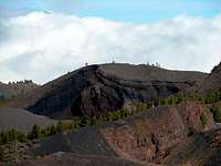
 Pico Nambroque seen from the north-east
Usually all year round the Canarias have the same weather with little alterations: north-eastern trade winds which deposit fog and dew on the north-eastern slopes of the islands. The western and southern parts usually are very dry and there you'll get some hours of sunshine each day. Especially on the higher islands like La Palma you usually don't have to worry about weather too much. The mountaintops will stick out of the clouds.
There are no reliable weather forecasts for the mountain regions of La Palma. Often a cloudless day turns into a foggy one within half an hour. Especially the Cumbre Vieja Range is prone to these fogs and here orientation among the lava and scree fields gets very difficult. This is the main reason why you should never leave the trails there.
Forecasts for the coastal regions, however are available. You have to subtract 1°C for every 100m of altitude so that Roque de los Muchachos will still be near freezing when the coasts have already fine and sunny beach weather. The following table gives a little overview about the average weather data of the capital of Santa Cruz:
| Month | Jan | Feb | Mar | Apr | May | Jun | Jul | Aug | Sep | Oct | Nov | Dec |
| Avg. day temp.[°C / °F] | 21 / 70 | 21 / 70 | 22 / 72 | 22 / 72 | 22 / 72 | 24 / 75 | 25 / 77 | 26 / 79 | 26 / 79 | 26 / 79 | 24 / 75 | 22 / 72 |
| Avg. night temp.[°C / °F] | 15 / 59 | 14 / 57 | 15 / 59 | 16 / 61 | 17 / 63 | 18 / 64 | 19 / 66 | 21 / 70 | 21 / 70 | 19 / 66 | 18 / 64 | 16 / 61 |
| Water temp.[°C / °F] | 19 / 66 | 18 / 64 | 19 / 66 | 19 / 66 | 19 / 66 | 20 / 68 | 22 / 72 | 23 / 73 | 22 / 72 | 22 / 72 | 21 / 70 | 20 / 68 |
| Sunny Hours / Day | 5 | 6 | 6 | 7 | 8 | 9 | 10 | 9 | 8 | 6 | 5 | 5 |
Maps & Books
- Maps
I have used a fantastic map by Freytag & Berndt which shows all of the many hiking and biking trails of the island. With its scale of 1:30000 it is still large enough to be useful for car tours as well. Moreover here you will find all the new designations and acronyms (which were changed some few years back).- La Palma
1:30000
Edition Freytag & Berndt
ISBN: 3-7079-0346-X
- La Palma
- Books
The guidebook I used is every bit as good as the map with excellent tour descriptions. It is available in English as well but I am not sure about the quality of the translation.- La Palma
A. and W. Wolfsperger
Rother Verlag
ISBN:
3-7633-4246-X (German)
3-7633-4808-5 (English)
External Links
- Megatsunami Paper
Scientific publication of the magatsunami theory of La Palma
- La Palma