
-
 8870 Hits
-
 83.69% Score
-
 17 Votes
|
|
Mountain/Rock |
|---|---|
|
|
48.36635°N / 114.48764°W |
|
|
4272 ft / 1302 m |
|
|
Overview:
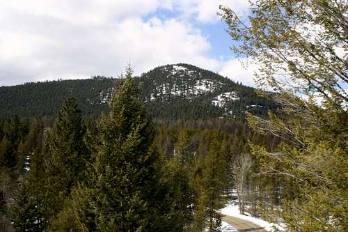 Pilot Knob
 The heart of the Salish Range
 The false summit
Layout designed for best viewing on a "1024 x 768" screen.
Pilot Knob is located in the Salish Mountains. Although this geographic feature is only 4,272 feet tall there are rewarding views into the northern Flathead Valley, the northern end of the Swan Range including Columbia Mountain, Teakettle Mountain in the Flathead Range as well as numerous summits in Glacier National Park.
Pilot Knob served as a fire lookout in the 1930s and was abandoned before World War II. There is little known about the lookout and it was snow covered in April when this writer visited the site.
The name of Pilot Knob is rather puzzling as to its name sake or the reason why it was named Pilot Knob. Wikipedia calls a “knob” a “prominent rounded hill or mountain.” It goes on to state that these knobs are particularly located in the Appalachians and the Ozarks. There are very few mountains in this portion of Montana that are called knobs. But this mountain really is a knob so the name is quite fitting.
Pilot Knob appears as a prominent landmark that is easily recognized in the northwest portion of the Flathead Valley. Perhaps it was used as a reference point from the air as early day pilots navigated the valley. Pilot Knob stands out above the lush green forests on the eastern side of the Salish Mountains.
Getting There:
 Looking south
 Looking up the south ridge
 Approaching the summit
Pilot Knob is located in the Salish Mountain Range and the Flathead National Forest.
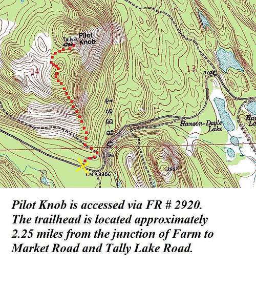
The route begins at the junction of the Tally Lake Road and Forest Service Road (FSR) # 2920. Please do not block the gate when parking. FSR #2920 is approximately 2.25 miles from the beginning of the Tally Lake Road. Do not confuse FSR #2920 with FSR #2924 which is about 1 mile before the correct road.
The Tally Lake Road is located off of Farm to Market Road which connects from U.S. Highway 93 north of Whitefish and Kalispell from U.S. Highway 2. There is a sign on Farm to Market Road indicating the correct road to turn on.
The Tally Lake Ranger District which is located at 650 Wolf Pack Way in Kalispell has maps available to $2.00. The Ranger District staff is quite helpful with directions as well as making other suggestions for activities. They can be reached via telephone at (406) 758-5200.
The map needed for this climb is Tally Lake Ranger District.
Red Tape:
 The view to the East
Please refer to the Flathead National Forest web site for the Red Tape.
As with all hiking and climbing in Northwestern Montana use caution and practice good manners with the wildlife. You are in bear and mountain lion country. Carry your bear deterrent, don’t hike alone and make some noise.
For more information please go to the Glacier National Park's web site for Bear Information. The U.S. Forest Service also has helpful information on Grizzly Bear Management.
Route Information:
 Pilot Knob Route
 Trip Distance: 1.4 miles
Trip Elevation Gain from Parking area to Pilot Knob summit: 906 feet
Directions to the trailhead:
Drive up the Tally Lake road 2.25 miles to FSR #2920.
Off Road Directions:
Walk along FSR #2920 for approximately .25 mile before taking off for the false summit of Pilot Knob.
Following the southern ridge is not difficult to navigate through but it may require some route finding through the forest growth during the initial climb. The route is laced with deer and elk trails but most of these trails follow contour lines and are not particularly effective in helping gain elevation.
The climbing is neither complicated nor challenging and is easy class 2. There is no risk of falling as there are no cliffs that must be climbed.
Continue gaining elevation to the false summit which is south of the true summit. It will be necessary to loose a little elevation to actually reach the summit of Pilot Knob. It can be reached in just a few more minutes.
Descent Recommendations to Consider:
It is my recommendation that the decent route be the same as the approach. I chose to skirt around the west side of the false summit and ended up having a longer return as the drainage to the west pushes the climber too far west. Retracing the approach route also helps avoid the private land that is located to the west of FSR #2920.
If you choose to follow the drainage west of the false summit make sure you follow FSR #2920 to the parking area upon reaching the road. Some of the folks that live here in Montana do not take kindly to trespassers especially if their land is posted with “No Trespassing” signs like this particular property west of where FRS #2920 starts.
A GPS is highly recommended as it is easy to get turned around.
When to Climb:
 Looking west from Pilot Knob
This climb can be done at any time of the year.
If the preference is for no snow plan on doing Pilot Knob anytime between May and the end of October, but snowshoes make this trip very enjoyable due to not having to deal with brush.
Essential Gear:
 Black Bear Scat
Bear Spray
Hiking Poles
Water
Camera
GPS
Hiking boots
Sun screen
 Elk Track
Camping:
The nearest Campground is located at Tally Lake. Make a reservation at Tally Lake Camp Ground Reservation.Tally Lake Campground is located in the Flathead National Forest approximately 12 miles west of Whitefish, Montana. There are 40 campsites, a boat launch and basic facilities, which include water, handicapped accessible restrooms and 40 specified campsites. Lake and stream fishing may be enjoyed as well as boating, swimming, canoeing, and hiking. There is a designated swimming area with a large grassy area with picnic sites. There are picnic tables, fire pits, and restrooms. Pets are allowed.
The fee for camping is $15.00 and day use fee is $3.00 per vehicle. Your stay may not exceed 14 days.
Weather:
External Links:
Visit MontanaFlathead National Forest