
-
 2922 Hits
-
 76.66% Score
-
 7 Votes
|
|
Route |
|---|---|
|
|
46.55805°N / 8.70289°E |
|
|
Download GPX » View Route on Map |
|
|
Hiking, Scrambling |
|
|
Spring, Summer, Fall, Winter |
|
|
Most of a day |
|
|
Easy hike up |
|
|
Overview
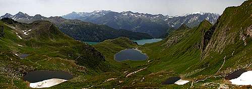
Great view from below Pizzo Taneda
This is a very nice summer hike on which one can experience the whole beauty of Piz Blas mountain group. First of all, there are many lakes and you really feel great walking from one lake to another and enjoying the nearby and more distant mountains mirroring in them. Paths are well marked and not difficult at all. Only the final ascent on Pizzo Taneda requires some minimum skills of path finding. The technical difficulty is all the time low - T1, by crossing steeper slopes on some places T2, and on the summit ascent possibly reaching T3 (if at all). You don't need any special gear in addition to good shoes and poles.
Getting There
See the parent page and the page of Lepontine Alps to learn how to reach Passo del Lucomagno!
From the south you get there from Bellinzona, in Biasca you deter northwards.
From the north, the road deters from the main road in Vorderrein valley in Disentis.
Route Description
To Passo dell'Uomo
From Passo del Lucomagno Hospiz you continue by the southern shore of Lai da Sontga Maria till the southwesternmost bay. There soon the path into Val Cadlimo deters towards the north-west (crossing a small bridge), but we continue in the same direction towards the south-west. We go by a not steep, but quite rugged cart road, which perhaps does not please mountain bikers who also use it. Gaining some altitude we almost reach the broad saddle. Before, another marked path into Val Cadlimo deters right. 1 h 15 min.
 Passo del Lucomagno |
 Near Passo dell'Uomo |
To Val Piora
From the hut on Passo dell'Uomo we continue in the same direction. After descending some 20 meters we reach a crossroads. The left variant goes towards the south and then descends into Val Piora via Alpe Carorescio (meadow). That path is wider and is used by mountain bikers. As we are on foot, we simply continue by the good path which goes north of the creek bed, descending slightly in the western direction. The whole upper Val Piora is picturesque, nice are also distant views on the mountains of Ticino/Tessin. The creek bed looks to be made of sedimentary rocks, so on a few places the creek carved a nice, white canyon. At the end the path brings us down to Capanna Cadagno, some 60 meters above the lake. 1 h 15 min.
 The upper Val Piora |
 In Val Piora |
 In Val Piora |
To Motta Hill
Now we must decide whether to go to Cadagno di Fuori huts directly, along the southern shore, or shall we encircle the dark, picturesque Lago Cadagno. The latter option is some 15 minutes longer, but the path along the eastern and the northern shore offers some great vistas and also the huts of Cadagno di Dentro are very picturesque. Reaching many houses of Cadagno di Fuori, we shall soon leave the crowds and take the north-western direction - by the path, going uphill. Across the slopes we ascend some 160 m, reaching a saddle north-east of Motta hill. It is more than a good advice to ascend that hill as well, 2115 m. The nice grassy dome offers a great view down on Lago Ritom (south), Lago di Tom (north) and Lago Cadagno (east). Nice is the southern panorama and with curiosity we are also examining the slopes, rising north of Lago di Tom, where our further ascent will go. 45 min (or 1 h).
 By Lago Cadagno |
 Cadagno di Dentro |
 Val Piora from Motta |
To Bassa Del Lago Scuro
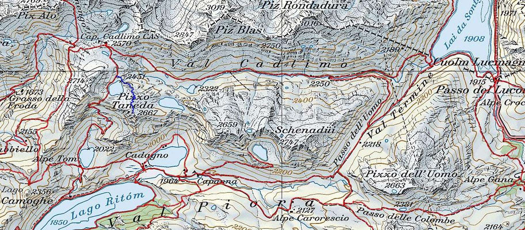
From the small saddle north-east of Motta, we don't need to descend to Lago di Tom, unless we want to take a bath on its nice beach (some indeed do so). By an unmarked (but good) path we simply cross above its eastern shore, not losing much altitude. After crossing the western ridge of Poncione Garioi (the summit south of Pizzo Taneda), our path soon joins the marked path, coming from the lake. Now we must do most of the altitude gain on today's tour. The path goes more steeply up the slopes, avoiding steeper rock sections of the slope. On the next terrace we are again passing two small lakes, called Laghetti di Taneda. From above the higher of them, the views down are especially beautiful - now you see already five lakes on different altitude levels. Then the path does the final ascent to the distinct saddle, 2477 m. On the other side a great view on Lago Scuro opens. 1 h 30 min.
 Lago di Tom |
 Laghetti di Taneda |
 On Bassa del Lago Scuro |
On Pizzo Taneda
So, coming from the south, it is now best to climb Pizzo Taneda directly, by its west ridge. We have only 200 m of elevation to do. The ridge is all the time easy, on some places you would think you follow a tiny path, but mostly it is a pathless terrain. Reaching the summit it is advisable to keep a bit left of the main ridge, because the northern slope is less steep. Take care also of lose rocks. The last meters of ascent we already do by a good path, coming from the north. 30 min.
 On Pizzo Taneda |
 Lago Scuro from Pizzo Taneda |
To Val Cadlimo
If you don't want to go to Capanna Cadlimo, where the marked path goes, you may do only the first 150 m of descent by the beaten path. First you go directly down, then you keep a bit towards the right. Then you may turn more towards the right (north-east), aiming nice meadows at Motto dell'Isra. The terrain is passable everywhere. Sooner or later it is good to ascend a bit on the other side of the valley, where the good marked path goes. By it you continue towards the right. It goes all the time above the nice creek. That is how you reach the huts of Stabbio di Mezzo, 2299 m, and Stabbio Nuovo, 2250 m. 1 h.
 Pizzo Taneda from Val Cadlimo |
 In Val Cadlimo |
 Cattle in Val Cadlimo |
To Passo del Lucomagno
Just below Stabio Nuovo hut you must again decide - whether to continue down by Val Cadlimo, or to cross the creek and go over (or better: around) the ridge into Val Termine, where you below Passo dell'Uomo hit the path by which you ascended in the morning. It looked to us no dilemma at all, so we continued by Val Cadlimo, but the group of hikers which we met by the hut, reached the goal just in the same time as us - and they went around! Val Cadlimo is in its lower part quite unpleasant for hiking. The valley is still beautiful, but gets rugged, the path starts going around boulders, stone plates, then the valley narrows into a nice, but quite wild gorge. Our path stops descending, but goes up instead! In several turns we gain some altitude, then start crossing towards the north-east some ravines. As right below there is still the gorge, the path never starts descending. Only when being already just above the lake, the path turns right down and and descends to the crossroads in Val Termine. Then along the lake shore we go to the hospiz. 1 h 30 min.