Preface - February 17th
This is a trip inspired by a friend of mine here in Colorado when she gives me a call sometime last November asking me to climb Whitney this winter. I jumped on the idea and planned to do it over Presidents Day weekend since I would have 4.5 days to give it a go. She never ended up going but I was committed. The original plan was to spend three days and climb the Mountaineers Route, camping both nights at Iceberg Lake. Although the trip ended up to be absolutely nothing of what we planned, we still had lots of fun. TRIP STATS: Mount Whitney attempt - 11 miles and 5000 feet elevation Death Valley and Manly Beacon - around 1500 feet elevation Telescope Peak/Rogers Peak - 16 miles and 5000 feet elevation And an invaluable visit to UNLV for a potential graduate school for me The drive was considerably longer than I had expected. We left Golden around 1pm on Friday the 17th and after many hours, of which I drove nearly the entire way, we arrived in Lone Pine around 4am and napped a couple hours before driving up to 8000 feet on the Whitney Portal Road where my front wheel drive ceased to go any further in the snow. It was on this long drive over that my climbing partner got sick and was unable to proceed up Mount Whitney. So great; what do I do? We brought hundreds of pounds of junk for the Mountaineers Route and now we were stuck. I certainly wasn't going to do this route alone in the winter so I decided to let him sleep in the car while I attempted the full Whitney trail solo.
Day 2 - February 18th
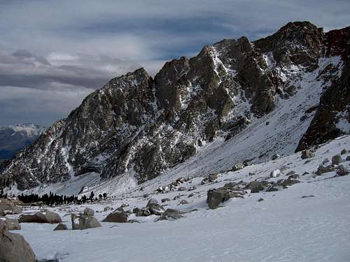
Arriving within a mile to the Whitney Portal trailhead I unpack by bag and drop just about everything since I was going to try Whitney as a day hike following the trail. All the overnight gear, pickets, ice screws, extra food and cooking gear I dumped in the back of the car and was on my way by 6:45 am. I was very tired from the long drive but I got going pretty quickly and started up the official trail, passing the turn-0ff for the north fork of Pine Creek and continued up the trail which by this point has a few inches of snow covering it with a very solid trench. Continuing up the numerous obnoxious switchbacks I come to around treeline before catching up to a couple guys who are also trying Whitney in a day but they started hours before me. I decided to join up with them from where we met at Mirror Lake and so we continued up to the left of the lake and passed treeline at which point the views really opened up nicely. The sun was out and I was getting my very first views of the Sierra Nevada Mountains. I had never been here before and I was liking what I saw.
![Near Mirror Lake]() My first views of the Sierras
My first views of the Sierras
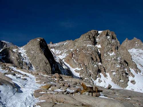
Since this was unfamiliar territory for me I had no idea what I was looking at most of the time but we continued onward passing by Consulation Lake which was frozen over. The spires above this lake I initially thought were Mt. Muir until I took another look at the map and realized that wasn't the case. We continued to the right up into the valley and hit Trail Camp.
![Looking down...]() Looking down Pine Creek Valley
Looking down Pine Creek Valley
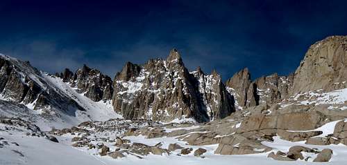
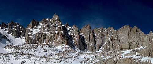
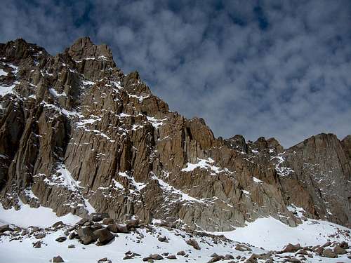
The trail was basically covered up so we just kept heading straight up the valley with our snowshoes on. Although the snow averaged only about a foot deep it was very unconsolidated so snowshoes helped a lot. Once at Trail Camp I got my first unobstructed views of a California 14er...Mt Muir. Boy this peak really is stunning.
![Mt. Muir]() Mt Muir Panorama Mt Muir Panorama | ![Muir Panorama]() Mt Muir Panorama Mt Muir Panorama |
![Mt. Muir]() Breaking my neck looking up at Muir
Breaking my neck looking up at Muir
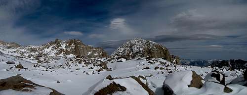
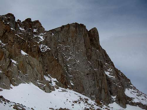
We took a short break here and continued up the valley heading up a steep snow slope to a high flat plateau at about 13,000 feet at the base of the vertical cliffs of Muir and Whitney.
![Sierra Nevada s]() View from this high plateau
View from this high plateau![Mount Whitney...]() Looking across to the summit of Mount Whitney
Looking across to the summit of Mount Whitney
To my dismay, clouds were quickly moving in and when I got only 200 vertical feet further, the clouds got increasingly lower and fog started hindering my views. Knowing that I wouldn't be able to see anything on the summit if I continued I concluded it was no longer worth continuing. Not only would I miss all the views, I would now have an excuse to come back and do the Mountaineers Route in spring. It was about 1pm when I turned around and made it down in about an hour and a half. Cutting out all the switchbacks on that trail really make the route a whole lot shorter.
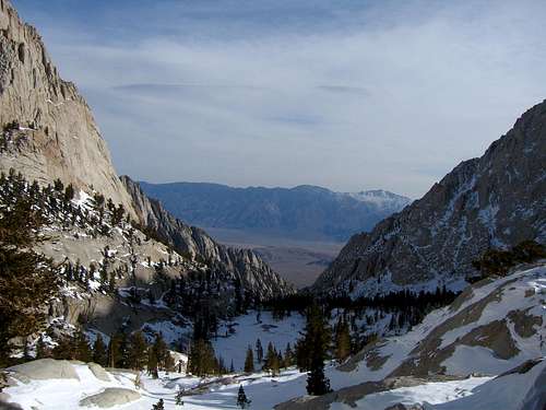
![Pine Creek]() A peek down to the Owens Valley
A peek down to the Owens Valley
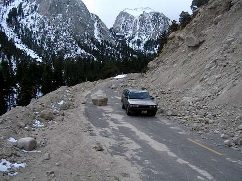
When I got back to the car, Stephan was sound asleep. I dumped my crap inside and we were on our way down to camp at the Alabama Hills. On the way down I shot this photo of the large pile of rocks that are on the road that took me by surprise on our way up in the dark...don't crash into these! The forest service has their work cut out for them this spring.
![Whitney Portal Road]() Rocks on the road
Rocks on the road
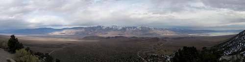
Views of the Owens Valley were spectacular!
![Owens Valley]() View looking down at the Alabama Hills
View looking down at the Alabama Hills![Owens Valley]() Contrasting Colors
Contrasting Colors
We found a nice spot to camp under a overhanging rock cave that we had a small fire at. Total distance for me was about 11 miles round trip with 5200 feet of elevation gain.
Day 3 - February 19th
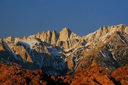
We woke to much colder temperatures and very windy conditions. I decided to get up early and try and shoot the sunrise on Whitney from the Alabama Hills and managed to get one good photo, also seen as the profile image for this TR.
![Whitney Sunrise]() Sunrise on Mount Whitney
Sunrise on Mount Whitney
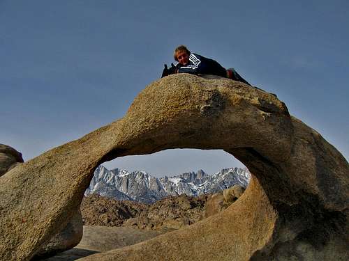
Shot this right from the comfort of my warm car. I noticed lots of photographers that took the walk to the Alabama Hills Arch for their sunrise photos but I liked the idea of staying warm. Later that morning after waking Stephan we decided it was too cold for the sport climbing we agreed to do the night before so we took the short walk over to the arch where I had a little fun.
![Alabama Hills Arch]() Me on the Arch with Whitney framed perfectly
Me on the Arch with Whitney framed perfectly
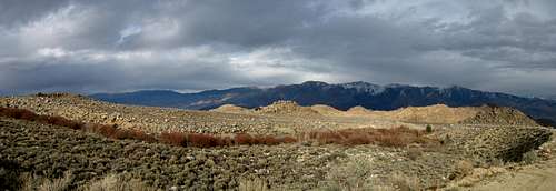
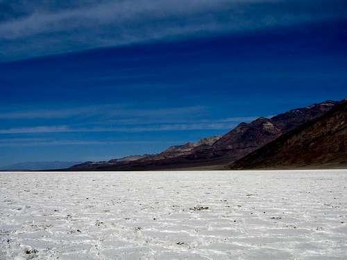
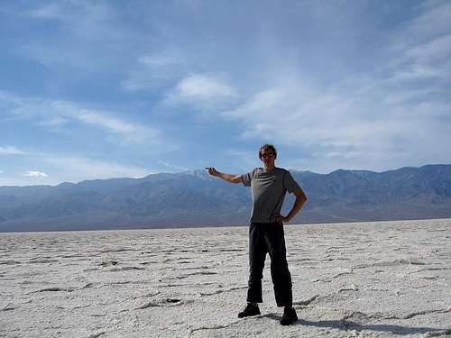
Geologically the Alabama Hills are very interesting. Very felsic intrusive bodies were shoved upwards partially as a result of the extreme faulting that created the Sierra block. These intrusive bodied never reached the paleo-surface so they cooled very slowly underground. Subsequent erosion of overlaying sediments exposed these more resistant rocks and the release of pressure fractured them extensively into their present, blocky form. They are known for great bolted climbing routes and bouldering. We decided to drive over to Death Valley and explore around there. Just to say we did, we had to go visit Badwater as it's the lowest place in all the western hemisphere. From here we got a great look at Telescope Peak which was to be the goal for the next day. It was downright hot down there at around 75 degrees in the middle of winter. I can imaging if you break down here in the summer you will die...in a matter of minutes!
![Badwater Basin]() Badwater Salt Flats Badwater Salt Flats | ![Badwater to Telescope]() Me pointing to Telescope Peak Me pointing to Telescope Peak |
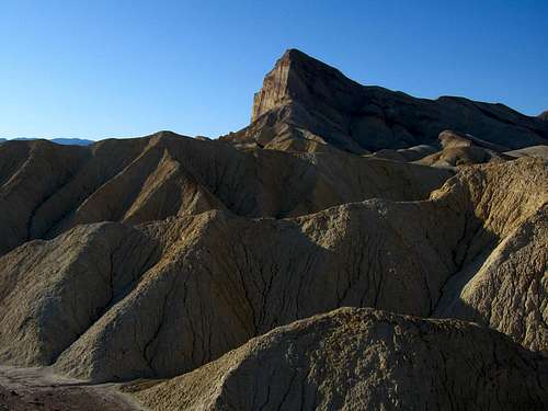
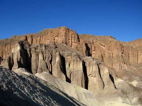
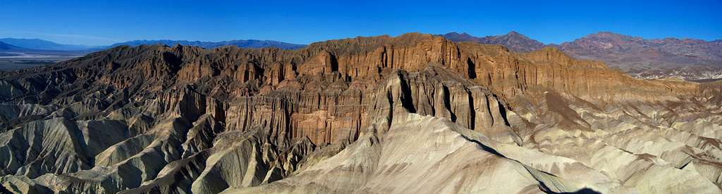
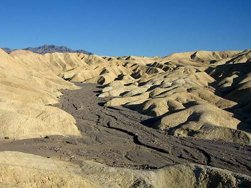
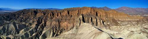
To my dismay upon returning to my car a park ranger was waiting for me since I had expired tabs. Wonderful...I had a pile of salt in my hands that I had to sneakily hide as I opened the door and grabbed my license. Didn't get a ticket but then again, I didn't even know they were expired. He must of knows I was hiding something as Stephan told me later it was blatantly obvious lol We drove over to Zabriske Point and in the late afternoon sun we hiked up Manly Beacon (which ever since reading Josh's TR I've wanted to climb, and I thought it was called Manly Bacon which still sticks in my head). From Zabriske Point there is a fantastic view of it...we just had to hike all the way down into Golden Canyon then hike back up. There scramble in the middle of the ridge up Manly Beacon was thrilling and the climb went so fast at this ridiculously low elevation.
![Manly Beacon...]() Manly Beacon from Golden Canyon Manly Beacon from Golden Canyon | ![Red Cathedral]() Red Cathedral from the saddle between it and Manly Beacon Red Cathedral from the saddle between it and Manly Beacon |
Soon enough we reached the summit and thought to ourselves how lame everyone standing at the overlook was. We planted ourselves in all their photos and we will be known as those crazy people when those tourists show their photos to their grandchildren years into the future!
![Summit view of Manly Beacon]() Summit view of Manly Beacon
Summit view of Manly Beacon
![Golden Canyon]() Hiking down Golden Canyon
Hiking down Golden Canyon![Manly Beacon Summit]() View from the summit of Manly Beacon
View from the summit of Manly Beacon
After the initial butt-scoot descent it was smooth sailing back to the car where we headed for the Charcoal Kilns to camp for the night. We pitched the tent inside one of these very well built kilns. It was a cloudless and dark night.
Day 4 - February 20th
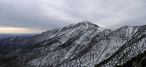
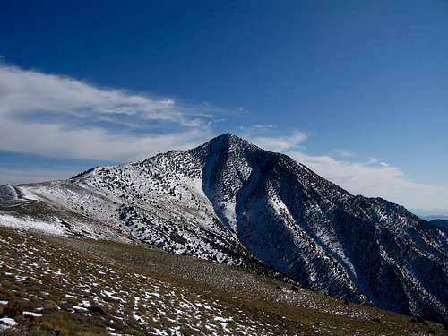
That next morning we woke to some low clouds as we prepared to start hiking up the road. Snow covered most of the road beyond the kilns making travel in my car not possible so we passed two campgrounds and at the Mahogany Campground, the Telescope Peak trail started. The goal for the day was to summit Telescope Peak. Continuing up the trail, the clouds were actually nice as they kept the wind down and the air a constant comfortable temperature. We continued on the trail completely encircling Rogers Peak and made it to the ridge that runs to Telescope.
![Morning on Telescope]() Morning view of Telescope Peak
Morning view of Telescope PeakWe continued to follow this gentle ridge and by 1pm we made the summit. There is a large ammo box on top with a first aid kit and large summit register that now has a Golden Bike Shop sticker on it...look for it!
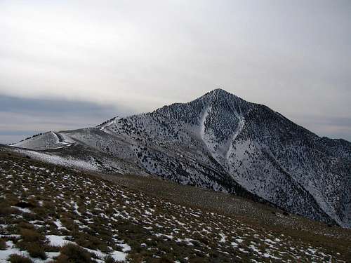
![Telescope Peak]() Approaching Telescope Peak Approaching Telescope Peak | ![Rogers and Bennett...]() Trekking up the steeper part of the ridge just below the summit Trekking up the steeper part of the ridge just below the summit |
![At the summit]() Finally cresting the summit area
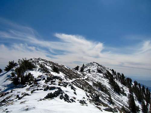
Finally cresting the summit areaWe spend quite awhile on the summit and before we knew it, all the clouds had burned off and left us fantastic views down to Death Valley, across to the Sierra Nevada Mountains (which were clouded in...wouldn't have ever guessed that lol). It wasn't really cold or windy either. Actually, most of the hike up was very quiet; almost too quiet.
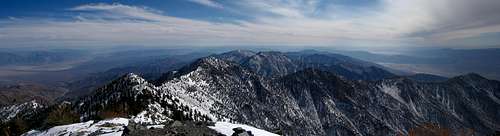
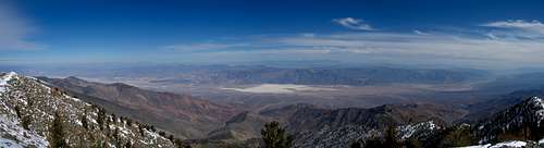
![Telescope Summit]() View north from the summit
View north from the summit![Death Valley]() View down to Death Valley from the summit
View down to Death Valley from the summitWe left the summit around 2pm and started the long haul back down to the kilns. We stayed on the trail going back down instead of the ridge directly which proved much faster. Getting one last look at Telescope before losing sight around Bennett.
![Sun hitting Telescope]() One last look
One last lookWe decided to hit the top of Rogers Peak and head down the service road on the other side hoping it would be shorter than the long trail. It was only an additional 300 feet of climbing and we nabbed another ranked peak however the road wasn't as steep and short as we'd hoped. It had lots of switchbacks and more snow sitting on it than I would have liked. To my surprise though people had walked it recently and someone even tried to drive it only to get turned around. Let's just say they were ambitious! Finally back at the car we met a couple coming to the kilns to shoot some photos and after seeing all our gear they realized we just hiked some 16 miles and offered us a beer. Never thought I could get so buzzed from one beer but if you don't drink or eat anything all day while working hard, it will do that to you! After driving out we began the long drive back to Colorado with a stop in Vegas so I could visit with some geology professors at UNLV as I'm interested in their graduate program. We even had to rescue a bipolar and terminal cancer patient who clearly needed help on the side of I-70 near Rifle at 2am on our way back...but that's another story for another time.
Looking Back
After reviewing this trip, there was absolutely things I was very happy about. Telescope Peak was much more scenic than I had expected and I described it as a very quaint place. It has a nice feel to it especially this time of year. I was certainly disappointed about not getting Whitney but I can return and do the Mountaineers Route in the spring, which I would be unable to do if I had summitted. Many of you know that my mountaineering goals prohibit me from repeating peaks but since I didn't make it this time I can come back. So the trip wasn't a complete failure...even doing Manly Beacon and visiting Badwater was worth the time. So until next time, I now have laid eyes on the Sierra Nevada Mountains and can't wait to get back!


Comments
Post a Comment