|
|
Route |
|---|---|
|
|
41.79256°N / 111.69353°W |
|
|
Hiking |
|
|
Spring, Summer, Fall, Winter |
|
|
Half a day |
|
|
Strenuous |
|
|
Overview
Preston Valley is the first trail that provides access to Beirdneau Peak in Green Canyon. This hike is found entirely in the Wasatch-Cache National Forest and the Mt. Naomi Wilderness Area. An easy to follow trail quickly takes you up to the ridge where the ridge can be followed to the peak. Saddleback Mountain can also be reached from this ridge. A good mix of forest and sun welcomes you. Wonderful views of Cache Valley and Logan Peak, as well as the Mt. Elmer/Mt. Jardine peak area are enjoyable.
Trail Length: About 4 3/4 miles one-way
Trailhead Elevation: About 5,640 ft.
Peak Elevation: 8,914 ft.
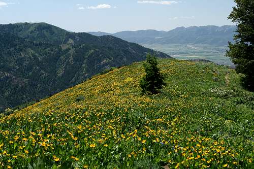
 A portion of the ridge hike
Essentials
1) Toilets are found at the Winter Parking Trailhead indicated on the map2) Plenty of water can be filtered from the creek near the trailhead
3) Map and compass
4) Appropriate seasonal equipment
Getting There
The Preston Valley Trailhead is found in Green Canyon of the Bear River Mountains. It is nearby the city of North Logan.To get to Green Canyon: From Highway 91 in Logan, also named Main Street, turn East on 18th North. At 1000 East, 18th west curves a bit and then becomes 19th North. Follow 19th North all the way into Green Canyon. The road turns to dirt after an electrical station. A winter parking lot is also located at the mouth of the canyon. The road is open seasonally and can be a bit rocky at times. But a high clearance, 2-wheel drive vehicle should be able to make it just fine. Be aware of frequent mountain bikers and ATVs along the road.
The Preston Valley Trailhead is 1.75 miles up the canyon. There are many pullouts along the way for campsites, but the one you are looking for will be on the right side of the road and will be much larger than any of the others you have seen up to this point. The trail starts at the eastern extreme of the pullout.
View Beirdneau Peak in a larger map
Route Description
This is an very easy route to follow. You will enter the Mt. Naomi Wilderness Area as you begin your trail. The trailhead is well indicated. The hike ascends quickly up to the ridge top. It is strenuous, but well shaded for much of it. The trail is also well maintained. At the ridge top, you will junction with the trail that starts from the Wind Cave Trailhead. From here, you will follow the ridgeline east. Beirdneau Peak is the obvious highpoint along the ridge. Nothing else comes close to it. The trail along the ridge is usually distinct, but can get multi-stranded at times. There are two nice, existing campsites along the way. The views of Logan Peak are amazing. The hiking should never get beyond class II hiking. Have fun and enjoy the views!