
|
|
Mountain/Rock |
|---|---|
|
|
41.79230°N / 111.69353°W |
|
|
Cache |
|
|
Hiking |
|
|
Spring, Summer, Fall, Winter |
|
|
8914 ft / 2717 m |
|
|
Overview
Sitting high in the Bear River Range of Northern Utah, Beirdneau Peak is the center of action. This mountain provides some of the most popular hikes and recreation in the area, but the peak itself is much less visited. This mountain combines with Mount Logan to create Logan Canyon, which is well-known for many quality recreational opportunities. This mountain also creates Green Canyon, which is also popular, especially with mountain bikers. It should not be a surprise that this peak should be a delight for peakbaggers, too. More popular peaks in the neighborhood heavily overshadow Beirdneau Peak, but this is usually a good thing for avoiding crowds.
 Photo by mountaingazelle
When to Go
The best hiking season is from around May to September. Due to the proximity to Cache Valley, a morning start is recommended for a cooler ascent. July is great for wildflowers.

Getting There
Multiple approaches can be used to climb Beirdneau Peak. Green Canyon and Logan Canyon both provide good access to this peak. Directions for both are provided here.This map shows the approximate routes that can be taken.
View Beirdneau Peak in a larger map
Green Canyon
Two Trailheads in Green Canyon can be used to hike this peak. They are Preston Valley Trailhead and Green Canyon Trailhead.
Green Canyon is located above the city of North Logan, and is also the northern neighbor to Logan Canyon.
From Highway 91 in Logan, also named Main Street, turn East on 18th North. At 1000 East, 18th west curves a bit and then becomes 19th North. Follow 19th North all the way into Green Canyon. The road turns to dirt after an electrical station. A winter parking lot is also located at the mouth of the canyon. The road is open seasonally and can be a bit rocky at times. But a high clearance, 2-wheel drive vehicle should be able to make it just fine. Be aware of frequent mountain bikers and ATVs along the road.
The Green Canyon Trailhead is 3.75 miles up the canyon
Preston Valley Trailhead is 1.75 miles up the canyon

Logan Canyon
Logan Canyon also provides two trailheads that can be used to reach Beirdneau Peak. They are Wind Cave Trailhead and Wood Camp Trailhead.
From Highway 89/91 (Main Street) in Logan, follow Highway 89 at 2nd North as it heads East. This takes you straight into Logan Canyon.
Wind Cave Trailhead is 5.3 miles up the canyon.
Wood Camp Trailhead is 11 miles up the canyon.
Red Tape
All possible routes reside within the Cache National Forest. You can visit the National Forest Information Center near the mouth of Logan Canyon on Highway 89.
In Green Canyon, the entire Preston Valley Route trails through the Mt. Naomi Wilderness Area. The Green Canyon Route also eventually crosses into the wilderness area.

Visit the home page of the Uintah-Wasatch-Cache National Forest
Please contact the Logan District Office for further information:
Logan Ranger District
1500 East Highway 89
Logan, UT 34321
(435) 755-3620
Current Conditions
Here's some useful links: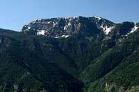
Avalanche conditions around Logan City
Wildfire Information for Utah
Road Conditions in the State of Utah
Weather Forecast from NOAA
Maps and Peak Data
USGS Maps: Beirdneau Peak
Mt. Elmer, UT 1:24,000
Logan, UT 1:100,000
Elevation: 8,914 ft.
Prominence: 494 ft.
Isolation: 3.03 miles
Utah Rank: 845
Cache County Rank: 24
County Prominence: 41
The peak was named after Nehemiah Wood Beirdneau as described in this photo.
Camping
Campgrounds
Several Forest Service Campgrounds exist in the area, especially in Logan Canyon. The Guinavah-Malibu Campground is nearly across the road from the Wind Cave Trailhead. The Wood Camp Trailhead has an adjacent campground.
Green Canyon has several semi-developed campsites near the stream throughout the canyon.
Backcountry
The steep ascents of Preston Valley and Wind Cave would be difficult to locate good campsites. A good site exists at their junction on top of the ridge. Camps can be made along the ridge in several places. One particularly good existing site lies between points 8143 and 8244 on the southwest ridge, if I am not mistaken.
Accomodations
The City of Logan and neighboring towns have many places to stay and also has many places to acquire maps and sporting goods.