
-
 16000 Hits
-
 82.48% Score
-
 15 Votes
|
|
Area/Range |
|---|---|
|
|
39.15420°N / 105.5835°W |
|
|
11570 ft / 3527 m |
|
|
Overview
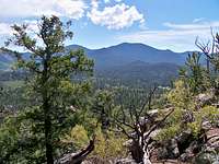
 Looking across the Tarryall Valley to the Puma Hills
The Puma Hills are relatively low, rounded, wooded mountains in central Colorado. These mostly gentle hills feature timbered slopes and neat outcrops of Pikes Peak granite. The highpoint of the Puma Hills is the aptly-nicknamed "Puma Peak" which rises to 11,570 feet, still below timberline in this part of Colorado. Like "Puma Peak" many of the summits in the Puma Hills do not have official USGS names on the map, lending to their sense of mystery and obscurity.
The heart of the Puma Hills straddles Hwy 24 at Wilkerson Pass (elevation 9507 ft). They are bounded to the east by the Tarryall Creek and to the west by the geological feature known as South Park. While the eastern and western boundaries are relatively easy to define, the northern and southern endpoints are a bit more elusive. In a proper sense, the northern boundary roughly coincides with the Tarryall Reservoir while the mountains run southward toward the Elevenmile Reservoir. However, on SummitPost and elsewhere, numerous nearby straggler summits that share similar terrain characteristics but do not formally have a range to call home, are often grouped in with the Puma Hills.
This is a laid-back, easy-going kind of mountain range full of peaks with no names and no trails to the summits. The Puma Hills are a place to visit when looking for gentle beauty and un-hurried solitude; for soft green trees swaying in the breeze against rosy granite and the rustle of wildlife in the woods.
Getting There
 Puma Peak from UN 9895
 Puma Hills from Sugarloaf Mountain
The Puma Hills sit on the eastern edge of South Park in Park County, Colorado. The mountains are about 75 miles as the crow flies southwest of Denver and roughly the same air distance northwest of Colorado Springs. The primary highway serving the area is US Hwy 24. Park County 77, a beat-up 2-lane semi-paved road, provides access to much of the eastern edge of the Puma Hills. Several US Forest Service gravel roads criss-cross the area.

Notable Peaks of the Puma Hills
 Laid back Farnum Peak summit
With Lady the dog
 Little Puma Flanked by Farnum (L) and Puma Peak (R)
| Image | Mountain | Elevation |
|---|---|---|
 | "Puma Peak" | 11,570 |
 | "Little Puma Peak" | 11,449 |
 | Farnum Peak | 11,337 |
 | Schoolmarm Mountain | 11,332 |

| Badger Mountain | 11,294 |
 | Martland Peak | 11,289 |
 | UN 11053 | 11,053 |
| Stoll Mountain | 10,873 | |
 | Pulver Mountain | 10,538 |
 | UN 10462 | 10,462 |
 | Rishaberger Mountain | 10,460 |
| Maria Benchmark | 9,898 | |
| Sulphur Mountain | 9,339 |
Flora and Fauna
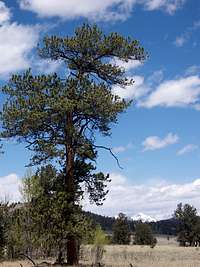 Ponderosa Pine
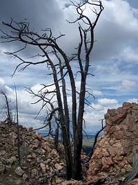 Charred pine on the summit of "Burntop"
Fauna
These mountains provide habitat for their namesake pumas (also known as mountain lions, catamounts or cougars), pronhorn antelope, black bears, bighorn sheep, mule deer and elk plus numerous birds and small critters.
Flora
The Ponderosa Pine is the ubiquitous companion of these mountains along with Quaking Aspen. The higher, north-facing reaches of these summits will host Douglas Fir. Near the very tops of the higher peaks a few old Bristlecone Pines thrive. The hotter, south-facing slopes host a variety of grasses plus Mountain Mahogany and yucca.
Land Ownership & Management
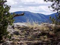
 Puma Hills roll in the distance from UN 8906
Much of the Puma Hills terrain sits within the Pike National Forest and, as such, is accessible to the public.
Camping & Lodging
 "Burntop" from Baker Mountai
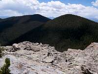 Little Puma_Foreground_and Puma from Farnum
Designated National Forest Service Sites
| Campground Name | Elevation | Sites | Nightly Rate | Reservations? | Notes |
|---|---|---|---|---|---|
| Blue Mountain | 8,200 ft. | 21 | $12 | Yes | Just a couple miles south of Lake George. |
| Spruce Grove | 8,600 ft. | 27 | $12 | No | Let the gurgling Tarryall Creek sing you to sleep. |
| Twin Eagles | 8,600 ft. | 9 | $8 | No | Must haul or purify drinking water. |
| Happy Meadows | 7,900 ft. | 8 | $12 | No | Situated along the South Platte River. |
| Round Mountain | 8,500 ft. | 16 | $12 | Yes | Drinking water, vault toilet and trash pickup. |
| Springer Gulch | 8,300 ft. | 15 | $12 | Yes | Situated within the Elevenmile Canyon; water, tables, fire grates. |
| Riverside | 8,000 ft. | 19 | $12 | Yes | Situated within Elevenmile Canyon; large grassy meadow with little shade. |
Lodges and Guest Ranches
Puma Hills River Ranch
Dream Stream Lodge
Ute Trail River Ranch
Bison Peak Lodge