

-
 47052 Hits
-
 85.36% Score
-
 24 Votes
|
|
Area/Range |
|---|---|
|
|
36.10460°N / 82.1223°W |
|
|
6286 ft / 1916 m |
|
|
Overview
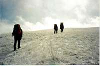
The Roan Highlands are a beautiful 12 mile ridgeline of Grassy and Heath (Rhododendron) balds; the longest anywhere in the world. They stretch north from the Roan High Bluff to Hump Mountain (known as "the Hump"), with the AT following the ridgeline from the Cloudland Hotel site (south of Roan High Knob) to the Hump.
South of Carvers Gap, the Roan Highlands are anchored by Roan High Bluff, the Rhododendron gardens, and Roan High Knob. Heading north from Carvers Gap are Round Bald (5826 ft),Engine Gap, Jane Bald (5807 ft), Grassy Ridge Bald (6189 ft), and Yellow Mt Gap (4682 ft). Continuing north are Yellow Mt (5460 ft), Little Hump (5459 ft), Bradley Gap, Hump Mt (5587 ft) before dropping to US 19-E. A side trail leads from Jane Bald to the summit of Grassy Ridge.
Roan Mountain, known to locals as "the Roan", are the peaks of Roan High Knob and Roan High Bluff; with a 1.5 mile connecting ridge between the two peaks. In mid June the Catawba Rhododendron, with its crimson red flowers, grace the mountain tops but are mostly concentrated on Grassy Ridge, Jane Bald, and the Rhododendron Gardens. The Rhododendron Gardens, in the saddle between the peaks, cover an area of 600 acres. There are 3 parking areas in this 1.5 mile saddle.
They comprise the largest display of blooming rhododendron to be found anywhere in the world today.
Much of the highlands between Roan High Bluff and Hump Mt is USFS land, with many acres being purchsed through the Nature Conservancy and Southern Appalachian Highlands Conservancy Many of the tracts are on Grassy Ridge, Big Yellow, and Hump mountains.See Nature Conservancy and Southern Appalachians Highlands Conservancy
--Letter from John Muir to his wife, written on the summit of Roan Mountain, September 25, 1898
"After lunch yesterday we walked 5 miles along the mountain top.... The open broad ridge top for miles is covered with rhododendron about 5 ft high which in flower must make a glorious show. Around the base of the rhododendron clumps there is a rich bossy growth of Leiophyllum buxifolia a charming heathwort. The temp. is distinctly alpine & for the first time since leaving home feel like my old self. I have been quite miserable but this air has healed me. ---"
 |
 |
 |
Little known facts
Between Roan High Bluff and High Knob, on the northern end of the first parking lot, is the site of the former Cloudland Hotel. The first structure was completed in 1877 and it was a summer destination for the "healthy high mountain air". At the turn of the century the hotel closed, then eventually abandoned with the land being sold to the USFS. An excellent book gives a well rounded history of man and the Roan Highlands; "A Passage of Time" by Jennifer Bauer Wilson.
Grassy Ridge (in the Roans), Tennent Mt, Black Balsam Knob, and Craggy Dome are the only mountains in the SE that are both >6000 feet and have a natural 360 degree view (though one can't see on Craggy unless you have a ladder or can see over the laurel).
Engine Gap is named so because a sawmill engine was found abandoned after it was used to cut timber for the Cloudland hotel.
In an early fall snowstorm of 1780, Yellow Mt Gap was the site of the movement on the Overmountain men. On Oct 7, 1780 this band of mountain men proceeded to defeat Major Patrick Furguson and his loyalist soldiers at Kings Mountain NC; destroying the left flank of Lord Cornwallis' British army. This defeat was followed in 1781 by the battle of Guilford Courthouse (a tactical British defeat) and thence to Yorktown.
Getting There
The Roan Highlands can be accessed by a paved state road at Cavers Gap (TN 143/NC 226), the Appalachian trail, and multiple gated roads and trails on both sides of the ridgeline. Consult USGS 7.5 Quads Carvers Gap, Bakersville, White Rocks Mountain, and Elk Park Tenn and or NC.
1) Drive from Roan Mt, Tennessee or from Bakersville, NC to Carvers Gap.To climb Roan High Knob, hike south on the AT for 1.3 miles to the blue blazed side trail, then 0.1 mile to the shelter. Or one may hike north on the AT to the 6 balds along the ridgeline.
2) Access to the Rhododendron Gardens by auto road. The road is
a 2 mile drive from Carvers Gap and gated from October to May. From the first parking lot head north on the AT for 0.6 miles to the blue blaze turnoff. To go to Roan High Bluff hike 1.5 miles south on the Cloudland trail to the summit.
3) A test of cardiovacular fitness is the 2.6 mile hike north on the AT from Hughes Gap (auto road) to parking lot #1. Follow the AT to the summit as described. This trail gains 2200 vertical feet and is one of the steepest climbs in the SE.
4)The AT on the ridgeline of the Roan Highlands can be accessed by multiple jeep roads and trails from the valleys below, both in TN and NC. Consult USGS 7.5' quads White Rocks Mt, Iron Mt Gap, Bakersville, and Carvers Gap
5) The northern end of the Roan Highlands (Hump Mt) is usually accessed by the AT. The climb from US 19-E is a sustained 2707 foot elevation gain in 5 miles. This section of the AT can also be accessed by by multiple trails on both sides of the state line.
Red Tape
No permits required for backpacking.
No fees required at Carvers Gap.
There is a $5 USFS fee at the seasonal station at Tollhouse Gap, which lies between Roan High Knob and the Cloudland Hotel Site. The tollhouse charges a fee to access the hotel site, Roan High Bluff and the rhododendron gardens by car.
As stated above the access road from Carvers Gap to the gardens is gated October to May.
When To Climb
Weather is variable but the in winter, when the balds are free of snow, the shaded areas of the Highlands may contain 1-2 feet. Also significant stretches of ice can be found on the graded trails in the shade and on north facing slopes.
Long stretches of icing on the AT are found on the north side of the High Knob, in woods climbing Round Bald, and the long decent from from Grassy Ridge to Yellow Mountain gap and up to western edge of the Yellow Mt summit ridge. All is caused by hikers travelling from Carvers Gap to Deep Gap and beyond to Yellow Mt Gap
Fall: Beautiful mountains and fall colors, with spruce forests above 4500 feet.
Winter temperatures: Above average snow (120"), can be below zero and windy.
Spring: Wildflowers galore
Summer temperatures: Pleasant, cool mountain nights beware of thunderstorms on balds
Camping
An AT shelter, the old Ranger cabin, is located near the summit of Roan High Knob and is the highest shelter on the AT). There are many campsites and 3 shelters (Stan Murray, Yellow Mt, and Apple House) on the AT between Carvers Gap and US 19E. Camping is not officially allowed on the summit ridge between the High Knob and High Bluff.
Aside from the seasonal restrooms at the first parking lot, permanent water is only found in 6 places in the 17.5 miles from Hughes Gap to US 19-E (Back side of Roan, Carvers gap, Back side of Grassy, Low Gap, Yellow Mt Gap, and Bradley Gap. Some is seasonal).
Mountain Conditions
Like most of the high peaks in the Southern Appalachians, weather can be extreme. Be prepared.In summer the weather can be outstanding. In winter one may find a trace of snow in the valleys and sun exposed balds but over a 1-2 feet on the ridgeline in the woods.
Be prepared. In November 2008 a hikers truck was discovered at Carvers Gap. His frozen body was found a month later on Grassy Ridge Bald.
The following link gives weather forecasts for the summit of Beech Mt, a few miles north of Hump Mt.
Beech Mountain weather forecast
Parking
Do not park your car on US 19-E overnight. This is the intersection with Bear Branch. This author has seen more than one car broken into, smashed or burned. Inquire at homes below Bear Branch Rd for parking. Parking is relatively safe at Carvers Gap