
-
 24698 Hits
-
 73.06% Score
-
 3 Votes
|
|
Route |
|---|---|
|
|
40.59390°N / 111.7203°W |
|
|
Hike with lengthy ridge scramble |
|
|
Most of a day |
|
|
Class 3 |
|
|
Overview
This route follows the ridge from the summit of Storm Mountain (el. 9,524 ft.) to the east summit of Broads Fork Twin Peaks (el. 11,330 ft.). The ridge traverse gains 1,800 feet over 1.6 miles, and involves route-finding, boulder hopping, and much ridge scrambling. | 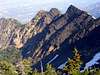 |  |  |  |
Getting There
From the 6200 South exit (exit #6) off I-215 follow highway 190 south-east approximately 2 miles to the intersection with Big Cottonwood Canyon road. Continue straight (south) through this stoplight for approximately 1/3 mile and turn left (east), then make an immediate right onto Prospector Drive at the T-junction. Approximately 1/4 mile beyond the T-junction turn left onto Timberline Drive. Proceed several hundred feet to the dirt road which leaves the main road on the right, which is where the trail begins. This is located in a residential area, so show consideration for the property owners.Stats
One-Way Hiking Distance: 5.0 milesTrailhead Elevation: 5,257 ft.
Summit Elevation: 11,330 ft.
Elevation Gain: 6,073 ft.
Average Gain per Mile: 1,215 ft.
Route Description
Naturally, you will first need to reach the summit of Storm Mountain, which is typically ascended via Ferguson Canyon. Refer to that mountain page for details on ascending that peak.From the summit of Storm Mountain proceed southeast along the ridge, losing approximately 100 feet of elevation before briefly leveling out at the saddle ±1/4 mile from the summit. This portion of the ridge forms the upper headwall of Ferguson Canyon on the right, with a precipitous drop into Stairs Gulch on the left.
Soon after the saddle the ridge will begin climbing steeply through pine forest before breaking above timber line at approximately 10,000 ft. Boulder hop the final few hundred feet to the summit of unnamed peak 10,350. To the south is a steep drop into the north fork of Deaf Smith Canyon, with the summit of Broads Fork Twins just beyond.
From unnamed peak 10,350 continue south-east along the ridge, which is exposed at times but presents no major difficulties beyond occasional 3rd class scrambling.
Approximately 1/4 mile beyond peak 10,350 the ridge will reach a prominent high point at approximately 10,600 feet, at the intersection with a ridge extending down to the north. This is the intersection with the ridge described in the Robinson Variation route, with approximately 3/4 mile of ridge remaining to the summit of Broads Fork Twin.
Continue following the ridge as it curves southward, gaining little elevation for a stretch until the ridge approaches the final scramble up the east twin. The summit can be ascended by traversing somewhat to the left along the east face of the ridge, but the most solid rock and best scrambling appears to be found by staying directly on the ridge to the summit.
Essential Gear
Portions of the Ferguson Canyon trail are quite steep - treking poles are recommended to save punishment on the knees.This is a long approach so carry sufficient water for a full day.