
|
|
Route |
|---|---|
|
|
37.71450°N / 119.6354°W |
|
|
Trad Climbing |
|
|
Spring, Summer, Fall |
|
|
Most of a day |
|
|
5.9 (YDS) |
|
|
IV 5.10c or 5.9 A0 |
|
|
11 |
|
|
IV |
|
|
Overview
Getting There


The trailhead for Cathedral Spires is located just east and before the junction with El Cap Meadow, parking available on the right side of the road. Access to Gunsight and routes on Middle Cathedral Spire is located approximately halfway between Bridalveil Falls and the El Cap Meadow junction.
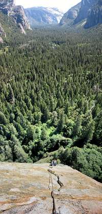
From the middle of the wide pull-out on the right side of the Southside Drive, hike into the woods for ~100 yards passing a climbers’ information sign. Turn right on the Valley Trail (main thoroughfare). In about 200 yards, you’ll pass the first turn off on left (marked with a post with a carabiner sign). Turn left and hike the climbers’ path uphill. The trail deposits you at the foot of a narrow boulder gully. Follow gully up few hundred feet till a large cairn appears in its center. Look right at this point and see another carabiner post on the right at the head of a path through the woods. Hike the path which will deposit you on The Pedestal within 150 yards of the talus. Route starts here.
Route Description
Pitch 1: 5.5, 110 feet. From the pedestal, climb the easiest line aiming for the right side of the prominent roof system 100+ feet above the pedestal. You pass several trees on their right. Belay (gear) on a brushy ledge beneath the large roof.Pitch 2: 5.8, 40 feet. Pull the 5.8 roof on the right (fixed piton….well beaten up by repeated falls) and follow ledgy terrain up and right. Belay (gear) on a large (8’ X 2’) flat ledge with a dying snag directly beneath a left facing dihedral. Pitches 1 and 2 can easily be combined with a 60 meter rope.
Pitch 3: 5.8, <100 feet. Move up the left facing dihedral, clip two pitons and undercling left and up around a large flake. Cut back right atop the flake to a decent ledge at the base of a right-facing dihedral (gear belay).
Pitch 4: 5.8, 100 feet. Climb the slick dihedral via liebacks and handjams. Few small ledges and similar dihedrals bring you to a good ledge with a bolted anchor. Pitches 3 and 4 can easily be combined with a 60 meter rope.
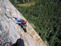
Pitch 5: 5.10c or 5.9 A0, 100 feet. Walk left 15 feet and climb the thin face protected by a bolt ladder (10c per Supertopo or A0). 30+ feet up (below last bolt), traverse a tiny ledge left 10 feet to a short, right facing dihedral. Stem up the dihedral (5.8) and pull a small roof (5.9) with good finger crack and flake on either side. Follow fun and easy flake/crack (great incuts and featured in Roper and Steck chapter photo) to a bolted belay on a good stance. Note that Supertopo provides a description for a variation starting on pitch 5.
Pitch 6: 5.8, 100 feet. Move up the low angle and easy (5.6) face, clip a piton and traverse rightward and slightly up. One cam placement behind an expando flake and one more piton put you next to a 5.8 friction move. Continue right to a sloping large ledge and a bolt anchor. Note that Supertopo provides a description for a variation starting on pitch 6
Pitch 7: 5.7, 140 feet. Move up a ledgy, left facing dihedral. At its top, step left 8 feet to a small stance beneath a long, flared groove. One piton and some micro cams make up the anchor.
Pitch 8: 5.8, 140 feet. Climb up the flaring groove directly above belay clipping one piton 15 feet up and possibly placing some micro-stuff in a crack that opens up higher up. At top of the “groove” step left onto face and traverse about 15 feet to a good large ledge. Belay on gear.
Pitch 9: 5.8, 100 feet. Move up a crack/flake on the left side of the ledge. Climb the flake/crack feature up and right clipping one piton. Belay on gear on a good stance with some greenery on it.
Pitch 10: 5.8, 160 feet. This looks like a 5.4 from the belay. Climb the left-facing dihedral (finger crack and pin scars). Step left to a thin hand/finger crack (5.8). The feature quickly peters out and you’re soon climbing more pin scars and stemming off two cracks. Before entering a lower angle V-shaped groove, step left and belay on a large ledge (careful, lots of loose rock!) on the left (gear).
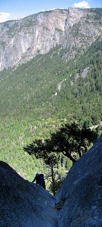
Pitch 11: 5.7, 140 feet. Step back right via 5.7 undercling move and enter an awkward but easy (5.7) V-groove. Climb the feature up. As you pass a huge evergreen growing in the groove, the angle kicks back and terrain becomes 4th class (and dirty – careful!). Belay when out of rope or when convenient.
Descent:
Getting To The Kat Walk: Scramble out of the V-shaped groove mentioned above heading up and right (just right of a rocky ridge terrain). This should put you on a well cairned bootpath (very exposed in places) heading gently up and into brushy area. Hike for about 100 yards following mostly clear cairns. Scramble up some class 3 gravel-covered slabs. About 300 yards from the top of the pitch you should get a nice view of the very prominent north prow of Upper Cathedral Rock. The trail then crosses some more exposed class 3 slabs as it gently turns left. Beyond the slabs, the trail is better worn and easier to follow (more cairns). It also levels off mostly. Follow it through the woods and brush (exposed in places once again) till you reach the top of a downward bound talus gully. Follow gully down for ~100 yards. It ends with a huge drop (careful) into the Middle-Upper CR gully. At this point, turn right following a faint path into the bushes as it skirts the edge of the huge drop. You’re headed for the top of the Middle-Upper CR gully.
Getting Down The Middle-Upper Cathedral Rocks Gully: Scramble down the gully (~200 feet) till you reach a bolted rap anchor. Either do one double rope rap or (there’s an intermediate station; low angle raps) two single raps. Scramble down for another ~200 feet and look for another bolted (but damaged!) rap anchor (left side of gully as you’re looking down). Do another rap off of slings around chockstones (short, ~50 feet). Keep scrambling down this gully (500+ feet?) till you come to the large cairn mentioned in the approach section. Turn left at this point and see the carabiner post and the approach trail headed into the woods towards The Pedestal.