
-
 18191 Hits
-
 75.07% Score
-
 7 Votes
|
|
Route |
|---|---|
|
|
37.64172°N / 107.68848°W |
|
|
Mountaineering |
|
|
Summer, Fall |
|
|
A few days |
|
|
Strenuous Backpack |
|
|
Overview
The Ruby Creek trail is one of the most strenuous backpack approaches in the San Juan Mountains. It is also one of the least traveled and most difficult trails to follow, giving out completely in some areas.Although this trail requires a high level of routefinding experience, the reward is reaching Ruby Lake and a seldom visited area. This is your primary access to Animas Mountain, Monitor Peak, Turret Peak, and Pigeon Peak. I backpacked this trail in the summer of 2010 and basecamped at an excellent site near Ruby Lake. Recently I came across the reworked Pigeon Peak page, and so I am adding this as a child to help people interested in reaching this area.
Since it has been a while since I was in this area, please send me a message if you have any updated info and I would be happy to include it here. Many thanks to some recent beta that sp members have sent to me. I have built two maps illustrating a tracked GPS route and I am including additional comments about the route at the end of the page. I would also like to solicit some pictures of the "trail" or at least the most confusing spots, if any members have any. Comments from members tell me that this trail is harder to follow than I remembered.
Getting There
The Ruby Creek trail will involve a backpacking trip with at least one overnight.The hardest part of the Ruby Creek trail is finding it. From the Needleton Trailhead (serviced by the Durango and Silverton Narrow Gauge Railroad, see green dot on map below) cross the bridge above the Animas River. Once on the east bank of the river, immediately leave the Needle Creek trail and turn left to follow a social trail that heads north on top of the river bank. I understand this social trail may be near some areas of private property, so please be respectful of those lands.
Continue north, crossing Pigeon Creek. Within a quarter mile, the social trail begins to thread and give out into several "pockets" of grassy meadows. Now leave the river trail and head east, walking gradually uphill through the meadows. Find your way to the farthest back of the most eastern meadow. In the southeastern corner of the most eastern meadow is where you find the Ruby Creek trail. On a large aspen tree next to the trail there is a bark-carving, which to me, looked like a woman in a dress wearing a hat.
Route Description
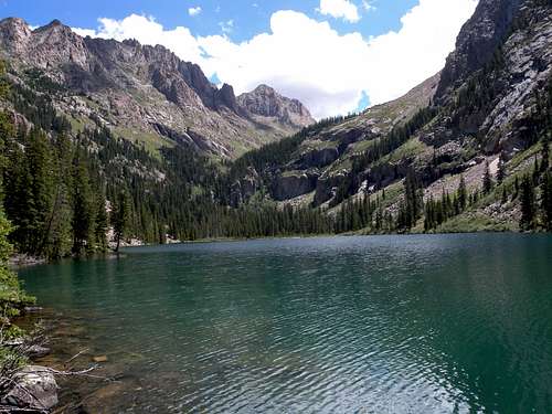
Ruby Lake from near the excellent campsite.
The trail segment between the unnamed creek at 9,500' and the intersection of Ruby Creek is the hardest to follow. In 2010 I remember it giving out completely in many areas. Several times I had to ask myself "if I were a trail where would I go?"
In particular, the trail encounters a rock face segment on its way from the ridge crest to the intersection at Ruby Creek. And like many other small trails in this situation, there is a route underneath the rock face and a route above it. Complicating things were several misleading cairns and survey tapes that people had left behind, ultimately pointing to everywhere and nowhere all at once. Pay more attention to the topography than to the cairns and survey tape. When the trail meets the rock face, you can choose either to descend left, or to scramble a class 3 pitch to the right. I remember preferring the short scramble up to the right, which led me around the top of the rock face and back to an identifiable trail segment. Yet on the way out, I somehow came in underneath the rock face, and then had to climb up from underneath it to rejoin my route. I found in both cases that I preferred the higher route above the rock face, and the lower route beneath it was much more slippery, muddy, and tedious.
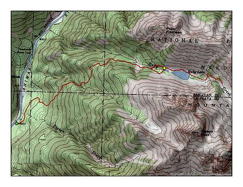
Topo Route
From the cleared area, in 2010, I could not identify any continuing trail segment. Cross here to the north side of the creek, and you will find that the vegetation is more clear underneath the trees. If you need, you can continue a little farther east before crossing to the north side of the creek. Once on the north side, simply bushwack eastward through the trees, keeping the creek to your right. After about 20 minutes you should regain an identifiable trail. Suddenly this pops right out at an excellent camp site (see yellow dot on map) which is on the west side of a small pond, just a few minutes west from Ruby Lake.
From this campsite, the trail continues around the north side of the lake. However it becomes harder and harder to follow. From Ruby Lake consider the rest of the basin to be off-trail.
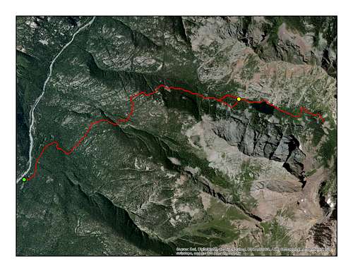
Aerial Route
Thanks and credits to Kiefer Thomas for providing the GPS track data, which I have overlaid onto these maps. This is the actual route that he and a friend took, with the exception that I have added an extra segment to mark where I crossed the creek at the cleared area below Ruby Lake (about 1/4 of a mile earlier than he did.) If you would like to add a specific comment about this route, please send me your info and identify what trail segment (i.e. first, second, third or last quarter) and the elevation of the location where your comment applies. This way I can post your comment and the reader can find the exact location on the map.
Kiefer - Oct 7, 2013 5:29 pm - Voted 8/10
Side note...Was just up there. At the top of the gentle ridge where the trail splits, continues left into Ruby Drainage or straight up the crest up into Pigeon Drainage, there is a craving of a columbine on an aspen tree on the left trail. This marks the correct trail for Ruby.
Sarah Simon - Oct 8, 2013 3:58 pm - Hasn't voted
Re: Side note...I think you mean "carving," not CRAVING. ;) -S