
-
 28901 Hits
-
 85.73% Score
-
 21 Votes
|
|
Mountain/Rock |
|---|---|
|
|
37.62740°N / 107.64°W |
|
|
La Plata |
|
|
Summer |
|
|
13835 ft / 4217 m |
|
|
San Juan Range, Weminuche Wilderness & Needle Mountains Overview
The San Juan Range is arguably the finest mountain range in the state of Colorado. The San Juans are the largest mountain range in the state and they dominate southwestern Colorado. In Colorado, the San Juans are second in snowfall only to the Park Range. The San Juan Range is home to 357 peaks above thirteen thousand feet.The Weminuche Wilderness is located twenty miles northeast of Durango, Colorado in the San Juan Range and was first established in 1975 (1). At 492,418 acres, the Weminuche encompasses portions of both the San Juan and Rio Grande National Forests. The Weminuche Wilderness is Colorado's largest wilderness area and is home to the beautiful Needle Mountains (1).
The Needle Mountains contain seven of the hundred highest peaks in the state (listed by decreasing elevation): Mount Eolus, Windom Peak, Sunlight Peak, Pigeon Peak, Turret Peak, Jupiter Mountain and Jagged Mountain. The Needle Mountains extend south from the Grenadier Mountains at the Peak Seven-Peak Eight col and are bound by the Animas River to the west and the Vallecito Creek to the east. See below for a list of the Needle Mountains above 13,000 feet and with at least 300 feet of interpolated prominence. Summitpost links are provided when available. When unavailable, Lists of John links are provided.
![Turret]()
The Turret Needles. Photo: Jack B
The Turret Needles. Photo: Jack B
| Peak Name | Rank | Prominence | Quadrangle | |
| Mount Eolus | 1 | 14083' | 2183' | Columbine Pass |
| Windom Peak | 2 | 1022' | Columbine Pass | |
| Sunlight Peak | 3 | 14059' | 399' | Storm King Peak |
| Pigeon Peak | 4 | 1152' | Snowdon Peak | |
| Turret Peak | 5 | 13835' | 735' | Snowdon Peak |
| Jupiter Mountain | 6 | 370' | Columbine Pass | |
| Jagged Mountain | 7 | 13824' | 964' | Storm King Peak |
| Animas Mountain | 8 | 1086' | Snowdon Peak | |
| Peak Six | 9 | 13705' | 685' | Storm King Peak |
| Grizzly Peak | 10 | 13700' | 440' | Columbine Pass |
| Peak Fifteen | 11 | 13700' | 320' | Snowdon Peak |
| Monitor Peak | 12 | 13695' | 315' | Storm King Peak |
| Peak Seven | 13 | 422' | Storm King Peak | |
| Greylock Mountain | 14 | 13575' | 555' | Columbine Pass |
| Leviathan Peak | 15 | 13528' | 400' | Storm King Peak |
| Peak Eleven | 16 | 588' | Storm King Peak | |
| Vallecito Mountain | 17 | 568' | Storm King Peak | |
| Peak Four | 18 | 13410' | 510' | Storm King Peak |
| Aztec Mountain | 19 | 610' | Columbine Pass | |
| Peak Five | 20 | 13283' | 303' | Storm King Peak |
| Knife Point | 21 | 325' | Storm King Peak | |
| The Heisspitz | 22 | 13262' | 362' | Storm King Peak |
| Mount Valois | 23 | 325' | Columbine Pass | |
| Amherst Mountain | 24 | 1225' | Columbine Pass | |
| Peak Twelve | 25 | 320' | Storm King Peak | |
| Sheep Mountain | 26 | 370' | Columbine Pass | |
| Organ Mountain | 27 | 452' | Columbine Pass |
Turret Peak Overview & History
Turret Peak is the highest of three Turret Peaks in Colorado, the 89th highest peak in the state and less than a half mile southeast of Pigeon Peak. Turret Peak was named because of its interesting rock faces and turrets and is the highest of the Turret Needles: Turret Peak, Peak Fifteen, Peak Sixteen and Little Finger. Despite its rugged appearance, Turret's easiest route, the Northwest Slopes Route is only rated Class 2+.The summit provides a great view of Pigeon Peak's east face and the Grenadier Mountains to the north. Turret's north face can be seen from the US 550 and CO 110 intersection outside of Silverton, Colorado. Turret's west face can be seen from US 550 south of Durango Mountain Resort. Turret's first recorded ascent was done by Albert R. Ellingwood & Barton Hoag on August 17, 1920 (2). The route they chose is the Northwest Slopes Route and is now the standard route.USGS Maps: Snowdon Peak & Mountain View Crest
![Turret Peak]() Turret Peak from the west.
Turret Peak from the west.![Turret]() Turret Peak and the Turret Needles. Photo: iceisnice
Turret Peak and the Turret Needles. Photo: iceisnice![]() Map of the Standard Northwest Slopes Route from Needleton. Click to enlarge.
Map of the Standard Northwest Slopes Route from Needleton. Click to enlarge.
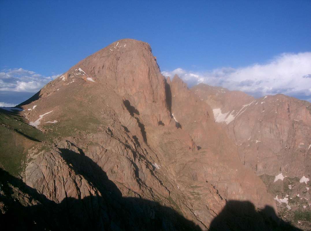 Turret Peak from the west.
Trailhead Information
Needleton Trailhead
The Needleton Trailhead is located 13 miles south of Silverton at 8,212' along the Animas River and can only be approached by foot or train. See the Getting There section for train details.Purgatory Trailhead
The Purgatory Trailhead is located along U.S. 550 south of Silverton & north of Durango at 8,800'. If driving from the south, start at 32nd Street and U.S. 500 in Durango and continue north along U.S. 550 for 24.7 miles to the trailhead. If you are driving from the north, continue south along U.S. 550 7.7 miles from Coal Creek Pass. The trailhead is on the east side of the road across from the ski area.Getting There
Access to Turret Peak is via Needleton, Colorado. Needleton is most commonly reached by the Durango Silverton Narrow Gauge Railroad. Roundtrip tickets cost $85 as of 2013. Avoiding the train requires an additional 1612 feet of elevation gain and 19 miles of hiking from the Purgatory Trailhead (3). Turret Peak's standard route is the Northwest Slopes Route and can be approached one of two ways, via North Pigeon Creek or Ruby Creek. Since the approach via North Pigeon Creek is easier, that is described in the Northwest Slopes Route Page. For information on the Ruby Creek approach, visit the Ruby Creek Trail page.North Pigeon Creek Approach
7.6 miles, 5623' of elevation gain, Class 2+Ruby Creek Approach
10.2 miles, 5823' of elevation gain, Class 2+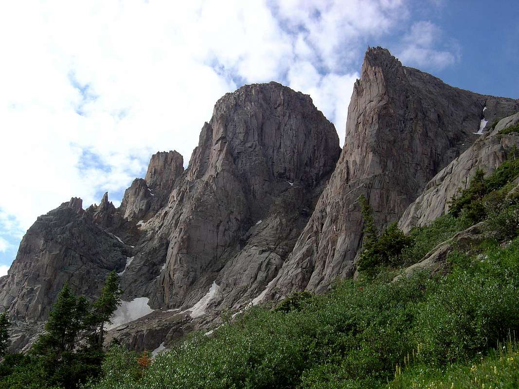 Turret Peak and the Turret Needles. Photo: iceisnice
Red Tape
Turret Peak is in the Weminuche Willderness; mechanized travel is forbidden.Camping
There are good sites at the 11,740 & 8,260 foot meadows in North Pigeon Creek and on the Animas River Trail, respectively.When to Climb
Turret Peak can be climbed year round, but is usually climbed from early May to late October when the Durango Silverton Narrow Gauge Railroad typically stops at Needleton, Colorado. The greatest objective danger in the fall-spring will be avalanche danger and during the summer will be lightning. If climbing during the summer, plan to be off of the summit and or/exposed ridges by noon.Map
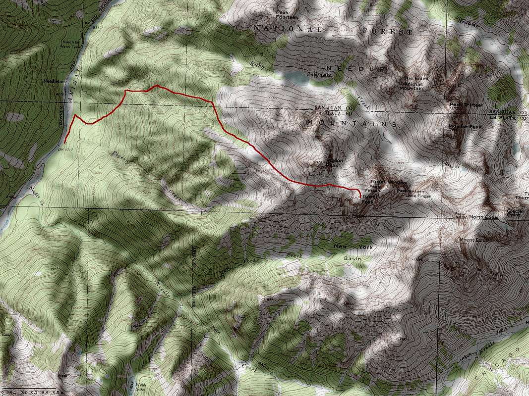 Map of the Standard Northwest Slopes Route from Needleton. Click to enlarge.