

dmiki - Sep 9, 2004 12:22 pm - Voted 10/10
I love this pictureWhis NASA website is it from?

Nelson - Sep 10, 2004 10:14 am - Hasn't voted
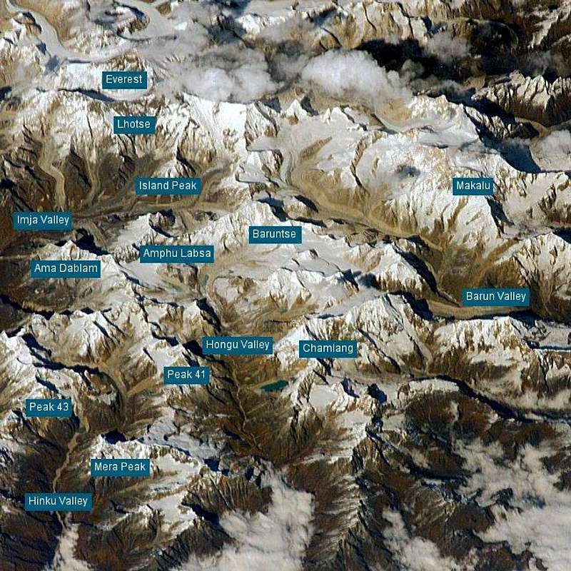
Re: I love this pictureIt is from Astronaut Photograpy of the Earth. It's pretty neat. They have a clickable map of the earth that lets you zoom in on a region. Then lots of search options, high and low-res images, and tons of pictures. Hopefully you have a fast connection! This picture I posted was cropped (and rotated) from a much larger image.

livioz - Nov 15, 2004 5:29 am - Voted 10/10
The best interactive image...I have ever seen! I discovered it thanks to Brenta.
Recently I too began to construct rougher interactive panos ( in Antonio's Torre del Gran San Pietro page), after that I had done some hand-made interactive maps (for example in Gangolf's page Gangolf's Pointe de Drone page )
I think it's possible to adopt the technique you used without putting the fixed labels on the photo, isn't it?
Cheers!
Nelson - Nov 15, 2004 9:03 am - Hasn't voted
Re: The best interactive image...Thanks livioz! Brenta and I had a great day out on Saturday.
You can do this sort of interactve image without labels, but you do need to make bitmap areas that react when the mouse moves into them. The labels are just useful as guides for where to move the mouse, but it can just as well be a feature on the photo or map. I've though of using this technique to illustrate climbing routes.
If you look at the page source you will see the Javascript I used originally came from here: http://www.dynamicdrive.com. I had to modify it a bit due to some quirks when re-editing pages: SP will insert line breaks if text lines are too long, and this was wrecking the code. It took me several hours to figure that one out.


Comments
Post a Comment