
-
 7668 Hits
-
 82.48% Score
-
 15 Votes
|
|
Mountain/Rock |
|---|---|
|
|
49.79689°N / 7.44133°E |
|
|
Trad Climbing, Sport Climbing |
|
|
Spring, Summer, Fall |
|
|
863 ft / 263 m |
|
|
Overview
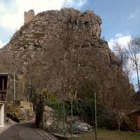
 Schwarze Wand east face Schwarze Wand east face |
To the north-west of Kirn in the Hunsrück mountain range you can find the quartzite climbing rwalls of the Kirn Dolomites. Several ridges head up on both sides of the Hahnenbach Valley, right above the ancient village of Kallenfels. On the eastern side the long ridge of Wehlenfels rises up to Baubelberg, while on the western side several massive rock formations tower above the village. They are the remnants of a big mediaeval castle, the castle of Stein-Kallenfels, built to overlook and regulate traffic in the valley. The castle is mentioned first in 1158, in 1615 it is already quoted to be falling apart and in 1682 it was blasted by French troops.
 Reconstruction of Steinkallenfels Castle by Wolfgang Braun. Schwarze Wand is the central of the three cliffs. |
The castle was built onto three of the quartzite crags in three separate sets of buildings. The lowest one - nowadays barely recognizable - was the castle Stock im Hahne, mainly a tower on a cliff with a building at its base. The second one was Kallenfels Castle (therefore the name of the village), several buildings with a watchtower on top. The last, highest and biggest one was Stein Castle, about a dozen buildings with walls, moats and towers. Of these three castles today only the ruins of Stein are left together with the foundations of the tower of Kallenfels. The latter can be found on a crag called Schwarze Wand.
 Schwarze Wand route layout by Thomas Hanne |
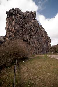
Schwarze Wand can be found directly above the village of Kallenfels. It accommodates the lazy climber as a small parking lot and a large picnic area can be found at its eastern base. The cliff can only be climbed from the east as this is the only side which is not located on private ground. The whole cliff is tilted so that the east face overhanngs for several metres. Thus, you can find no easy climbs here, the ratings are between 4+ and 7+. On the other hand, the usual blocky quality of the Kirn Dolomites quartzite prevails offering perfect belaying and resting ledges where you need them.
 |  |  |
Schwarze Wand is very popular among the local climbers. Of course the proximity to the next parking lot is the main attraction but most of the face is open to the sun for most part of the day, resulting in good conditions late into the year. During the time from Feb 15th through JJuly 15th the crag is closed to climbing each year - peregrines, owls and other birds of prey use to nest there. Neighbouring Stein Castle has also been closed to visitors. The old walls and ramparts are finally falling to pieces making the castle grounds a very dangerous place. About 25 years ago I climbed it with who became my brother in law. Even then the whole place was falling apart. Mines had opened among the rocks, old towers had crumbled. A steep and narrow path led to te "main building", a path you had to crawl on all fours.
Getting There
 Schwarze Wand (left) and Stein Castle (right) seen from Wehlenfels
Kirn is located very close to the airport Frankfurt / Hahn, which is served by low budget airlines. A narrow and winding country road, L182 connects to it directly.
More likely the potential aspirant will start somewhere near Frankfurt. He'll reach Kirn by the following itinerary:
- From Frankfurt take motorway A3 west in direction of Köln / Wiesbaden
- At intersection Mönchhofdreieck switch to motorway A67 south, direction Darmstadt / Mainz
- At intersection Rüsselsheimer Dreieck switch to motorway A60 west, direction Mainz / Bingen
- As you cross the Rhine River wave across the quarry pit on the left hand side. I'll wave back if I see you.
- After crossing three more motorway intersections A60 will take you to Bingen
- At intersection Dreieck Nahetal switch to A61 south, direction Alzey / Ludwigshafen
- At the next exit lleve for B41 direction Bad Kreuznach / Kirn / Idar-Oberstein
- Just before you reach Kirn leave the highway for the town centre
- Switch to L182 which will take you to Kallenfels
- In the village turn right into Schloßweg.
- Turn left into Eulenweg, then into Burgweg. The narrow road will take you to a parking lot right underneath Schwarze Wand
Red Tape
 Stein Castle across the gap from Schwarze Wand
Schwarze Wand is closed to climbing each year between Feb 15th and July 15th. Also, only the east face may be climbed while the west, south and north faces end in private property.
Accommodation
CampingThere is a campground to the south-west of Kirn. Owner is Egon Andre, Tel.: +49 6752 2267
Hotels
Google Search
Weather Conditions
Maps & Books
Maps
Digital Maps
You can get the official 50k and 25k maps as software CDs, to be found on the web page of Landesvermessungsamt Rheinland Pfalz.
- CD-ROM 1:50 000 Rheinland- Pfalz/Saarland 4.0
1:50000
ISBN: 3-89637-336-6
- CD-ROM 1:25 000 Nr. 3 Mittelrhein Taunus Rheinhessen
1:25000
ISBN: 3-89637-346-3
Regular Maps
Also by Landesvermessungsamt Rheinland Pfalz you can get topographic maps of all scales:
Books
- Kletterführer Rhein Main Gebiet
Ch. Deinet
Panico Alpinverlag, 2002
ISBN: 3-926807-76-8
Online Climbing Guide
There is a wonderful online climbing guide, which is an excellent addition to the guidebook above: