
-
 7357 Hits
-
 77.48% Score
-
 8 Votes
|
|
Mountain/Rock |
|---|---|
|
|
49.79483°N / 7.43822°E |
|
|
Trad Climbing, Scrambling |
|
|
Spring, Summer, Fall |
|
|
1053 ft / 321 m |
|
|
Overview
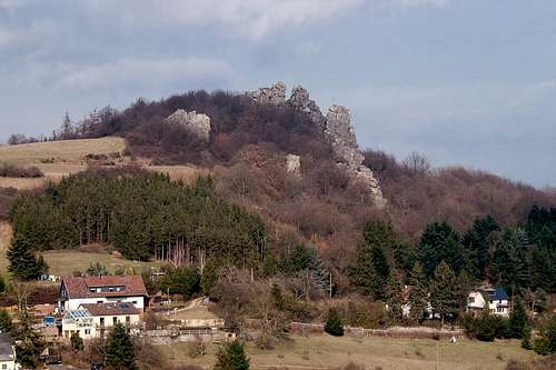
 Wehlenfels seen from the village Kallenfels Wehlenfels seen from the village Kallenfels |
An alpine route in the middle of Germany? In what we call "Mittelgebirge" (Mid-sized Mountain Ranges)? In the Hunsrück Range, the highest summit of which is Erbeskopf at 816m? Naturally you won't find the real thing but there is one place to the west of the town Kirn on the Nahe River, which comes as close as it can get.
Wehlenfels is a 400m long ridge in the Kirn Dolomites, which heads up the east slopes of Baubelberg, a small mountain located west of the village of Kallenfels. Like all the climbing crags of Kirner Dolommiten it is made up from quarzite blocks. The ridge heads up the mountain in a straight lineand consists of four separatecliffs, which are connected by three saddles. Most likely it is the best training ground for alpine ridge traverses in the greater Rhein-Main Area of Germany as it posesses all ingredients of a difficult ridge traverse - minus the height and the length.
 |  |  |  |
As already said, there are four different sections of cliffs on Wehlenfels. The most difficult ones are at the base of the ridge while the upper part ends somewhat unspetacularly on top of Baubelberg. As ridge traverses go - this one is not overly difficult. Most of the seven pitches go at difficulties between UIAA I and III. Only the second section, Betende Jungfrau (Praying Madonna) gues at UIAA V-. A short glimpse at the cliff will tell you why.
Like Oberhäuser Grat on the other side of the Hahnenbach Valley, Wehlenfels is a climbing crag for everyone who is familiar with heights. Some of the most difficult sections - like Betende Jungfrau can be passed on more or less exposed ledges and there are a couple of steep gullies which let you turn back to the ridge. These latter - while not exactly difficult - can be pretty dangerous. They are filled with loose earth and thin bushes, so that the climb can turn into a scrambling bushwhack with high exposure.
 |  |  |  |
Generally, Wehlenfels is not climbed too often. You can tell by the vegetation which covers its sides, ledges and gullies. The greatest danger on the crag lies in the moss covered rocks (thick moss which clings on loosely) and the omnipresent blackberry brambles. Catch one of these in the fabric of your pants and an easy ledge traverse can turn into a fierce bloody struggle not to fall. Especially the fourth and topmost sectionis very dangerous.
The regular route climbs across the first and second sections, passes the third to the left, then climbs it along a crack system and finally ends in a scramble onto the fourth cliff. The latter is often avoided due to the lack of interest (and the blackberries to be honest). An alternative route - the scramblers route also passes the start of the third section, but on the right hand side. It then heads up one of two gullies to the ridge, where after passing to the left hand side a ledge system takes you to the next saddle. This latter route is rather engaging and amusing for hard-core hikers like me.
Wehlenfels is usually climbed in the fine season - late spring through early autumn. On a fine winter day, however, you can take advantage of the missing foliage. Views towards Schwarze Wand, the castle ruin Steinkallenfels and Oberhäuser Felsen are wonderful.
Sometimes Wehlenfels is dubbed Kopftörlgrat in longing remembrance of the wonderful ridge which leads up Elmauer Halt in Kaisergebirge.
Getting There
 The Kirn Basin as seen from the summit of Wehlenfels
Kirn is located very close to the airport Frankfurt / Hahn, which is served by low budget airlines. A narrow and winding country road, L182 connects to it directly.
More likely the potential aspirant will start somewhere near Frankfurt. He'll reach Kirn by the following itinerary:
- From Frankfurt take motorway A3 west in direction of Köln / Wiesbaden
- At intersection Mönchhofdreieck switch to motorway A67 south, direction Darmstadt / Mainz
- At intersection Rüsselsheimer Dreieck switch to motorway A60 west, direction Mainz / Bingen
- As you cross the Rhine River wave across the quarry pit on the left hand side. I'll wave back if I see you.
- After crossing three more motorway intersections A60 will take you to Bingen
- At intersection Dreieck Nahetal switch to A61 south, direction Alzey / Ludwigshafen
- At the next exit lleve for B41 direction Bad Kreuznach / Kirn / Idar-Oberstein
- Just before you reach Kirn leave the highway for the town centre
- Switch to L182 which will take you to Kallenfels
- In the village turn right into Alter Kirner Weg which will take you to a bridge, Kunobrücke. There is a small parking space right before the bridge.
Red Tape
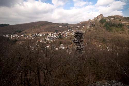
 Oberhäuser Felsen seen from Wehlenfels
Basically there is no red tape here. Glas has become a major problem in the last few years. At the bases of some of the rocks big quantities of broken bottles have been found. Take care for yourself and your ropes! And don't follow the bad example!
Accommodation
 Kallenfels seen across Betende Jungfrau
Camping
There is a campground to the south-west of Kirn. Owner is Egon Andre, Tel.: +49 6752 2267
Hotels
Google Search
Weather Conditions
Maps & Books
 Wehlenfels Ridge
Maps
Digital Maps
You can get the official 50k and 25k maps as software CDs, to be found on the web page of Landesvermessungsamt Rheinland Pfalz.
- CD-ROM 1:50 000 Rheinland- Pfalz/Saarland 4.0
1:50000
ISBN: 3-89637-336-6
- CD-ROM 1:25 000 Nr. 3 Mittelrhein Taunus Rheinhessen
1:25000
ISBN: 3-89637-346-3
Regular Maps
Also by Landesvermessungsamt Rheinland Pfalz you can get topographic maps of all scales:
Books
- Kletterführer Rhein Main Gebiet
Ch. Deinet
Panico Alpinverlag, 2002
ISBN: 3-926807-76-8
Online Climbing Guide
There is a wonderful online climbing guide, which is an excellent addition to the guidebook above: