
|
|
Route |
|---|---|
|
|
36.56170°N / 118.224°W |
|
|
Technical Rock Climb |
|
|
A few days |
|
|
V 5.10 A0 |
|
|
Introduction
All streets of the mountains lead to the citadel; steep or slow they go up to the core of the hills. Any trail that goes otherwhere must dip and cross, sidle and take chances. Rifts of the hills open into each other, and the high meadows are often wide enough to be called valleys by courtesy; but one keeps this distinction in mind, -- valleys are the sunken places of the earth, canons are scored out by the glacier ploughs of God. All mountain streets have streams to thread them, or deep grooves where a stream might run.From: The Streets of the Mountains, The Land of Little Rain by Mary Austin
Approach
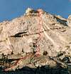
First ascent of The Streets of the Mountains on September 4-6, 2004 by Miguel Carmona and Joe LeMay. The route climbs 14 pitches on the south face of Lone Pine Peak. It is located on the westernmost part of the south face. This face features a huge left facing corner, with two horizontal orange bands. Our climb traverses into the corner just after the first band and follows the corner, exiting out the right side of a roof high above. It then climbs between the buttress towers on the skyline.There are no other climbs located on this part of the face, as far as we know. There is 10 feet of aid on pitch 8, but this will most likely go free at 5.10+, or we believe pitches 7 and 8 can be bypassed with pitches onto the face on the left at 5.10. We favor this variation. It might require pins and a drill kit. The rock quality and type of climbing varies throughout the route. On the first ascent we bivied once on a ledge at the end of pitch 3, and once at the end of roped climbing, just below the summit plateau.
From the Stone House, follow intermittent paths up the south (left) side of the north fork of Tuttle Creek. Use the same approach that one would take to get to the Red Baron Tower, staying high on the south side. After 3-4 hours of approach, you are just above the face at a point where the South Gully intersects the stream coming from further up the Canyon. The South Gully is a 4th Class gully that separates Lone Pine Peak from Peak 13,016. Head up the South Gully for a short distance before heading up and right on tree covered ledges. You will arrive at the wall on a ledge with two large pine trees high above the canyon in about another hour.
 |  |
Route Description
The Streets of the Mountains starts between the two pine trees, below a 20-foot wide roof at a left facing crescent crack. A cairn is located at the base. The route follows features diagonally up and right before it joins the huge left facing corner at the first orange band. It follows the corner through the second orange band before exiting a huge roof at an alcove on pitch 11. It then climbs one further pitch before the angle backs off into easier climbing.The start: between the pine trees hike up a ramp into a slot that is just below the roof.
1) Climb out right below the roof into a wide crescent crack ending at a ledge with a pin (5.7) (80 ft.).
2) Climb a groove up and left then up (5.9) into a slot. Traverse right onto the face (5.10a) to a horn, then to a wide lieback flake to a sling belay in a hole in the flake. (110 ft.)
3) Continue up the flake to a left facing corner with a pin. End at a 3 ft. wide ledge. (5.9) (100 ft.) At the left edge of this ledge, one can descend down and left to an excellent bivy platform for two. (We spent the first night here.)
4) From the right end of the ledge in the corner, climb up then left around a block then back into the corner. Continue up the face at the first orange band and traverse into a wide chimney. Belay up high in the chimney. (5.9) (100 ft.)
5) Full body chimney up then lieback a flakey section into a left facing corner. Continue stemming up to a 3 ft. wide ledge on the right. (5.8) (165 ft.)
6) Continue up the corner (5.9) onto easier climbing. Above there is a huge chimney. Move right onto a big loose platform (80 ft.).
7) Move right into a steep left corner and stem/lieback up to a 1 ft. wide ledge. (5.9) (80 ft.)
8) Aid (A0) past a pin and into a very wide crack. Climb (5.10) up the crack a short distance onto loose rock. Continue, ending on decomposing rock. Belay from a large slung block pedestal. (110 ft.)
9) Climb right through ledges and up the second orange band. End at a huge platform at the continuation of the left facing corner. (5.7) (100 ft.)
10) Climb out left and up onto the face following features. Traverse back to the corner then into an alcove on the right below the huge roof. (5.7) (110 ft.)
11) Climb up the right side of the alcove (5.8), and then move left on the face to a 6 ft. ledge. (110 ft.)
12) Easy terrain ends at a gully dropping to the left. (100 ft.)
13) 50 ft. left and below the notch climb up on easy 5th ledges. (150 ft.)
14) One more pitch of roped climbing continues on easy 5th ledges. 200 ft. further is the summit plateau. We bivied a second time at the end of roped climbing.
We descended down the South Gully back to the start of the climb and our approach gear. Plan on a 4-hour descent to the start of the climb if the descent gully is found easily and negotiated smoothly. From the end of the climb, head up and left to near the skyline on the left. Keep traversing west above two lower buttresses and find the South Gully after about an hour. We constructed a cairn at the start of the gully on a four-foot tall boulder. Don’t descend too soon or there could be death slabs.
In the gully, stay mostly on the left side and occasionally in the gully. There is a double rope rappel from pins, near the end of difficulties. Further down, traverse left onto the huge ledge that leads to the start of the climb.
 |  |
Essential Gear
Climbing gear:1 set stoppers
1 set TCUs to #4
1 ea #4, #3, #2, #.75 Camalots
1 set rigid friends up to #4
#6-11 Hexes
15 runners
6 double lengths slings
Double ropes (50m)
Jumars (optional)
The second carried the single pack with two sleeping bags, water, and extras, and jumared.