|
|
Route |
|---|---|
|
|
40.53300°N / 111.6805°W |
|
|
Basic Snow/Scramble |
|
|
Most of a day |
|
|
Class 2 & 3 |
|
|
Approach
The south face is approached from the Silver Lake Trailhead, which begins at the Silver Lake Flat Reservoir.
Click for the Full Trip Report on my photography website.
To get to this reservoir, take I-15 to the Highland/Alpine Exit (#287), turn east onto UT-92. Continue east on this highway and you will arrive at the mouth of American Fork Canyon. There is a Forest Service Toll Booth and a $3.00 fee for a three-day pass on the road. Continue up the canyon until you reach the first major fork in the road. Turn left toward Tibble Fork Reservoir. Once you reach the reservoir, go to the east end of the parking lot and you'll find a dirt road that goes straight ahead to Mineral Basin (Snowbird), and an asphalt road that goes left to Granite Flat Campground. Go left on the asphalt road. As you reach the toll booth for Granite Flat Campground, there is a well-maintained dirt road that goes right, up the hill. Follow that dirt road three miles to Silver Lake Flat Reservoir. Drive to the north end of the reservoir and park in the large parking lot. The trailhead to Silver Lake begins next to the restrooms and the information board.
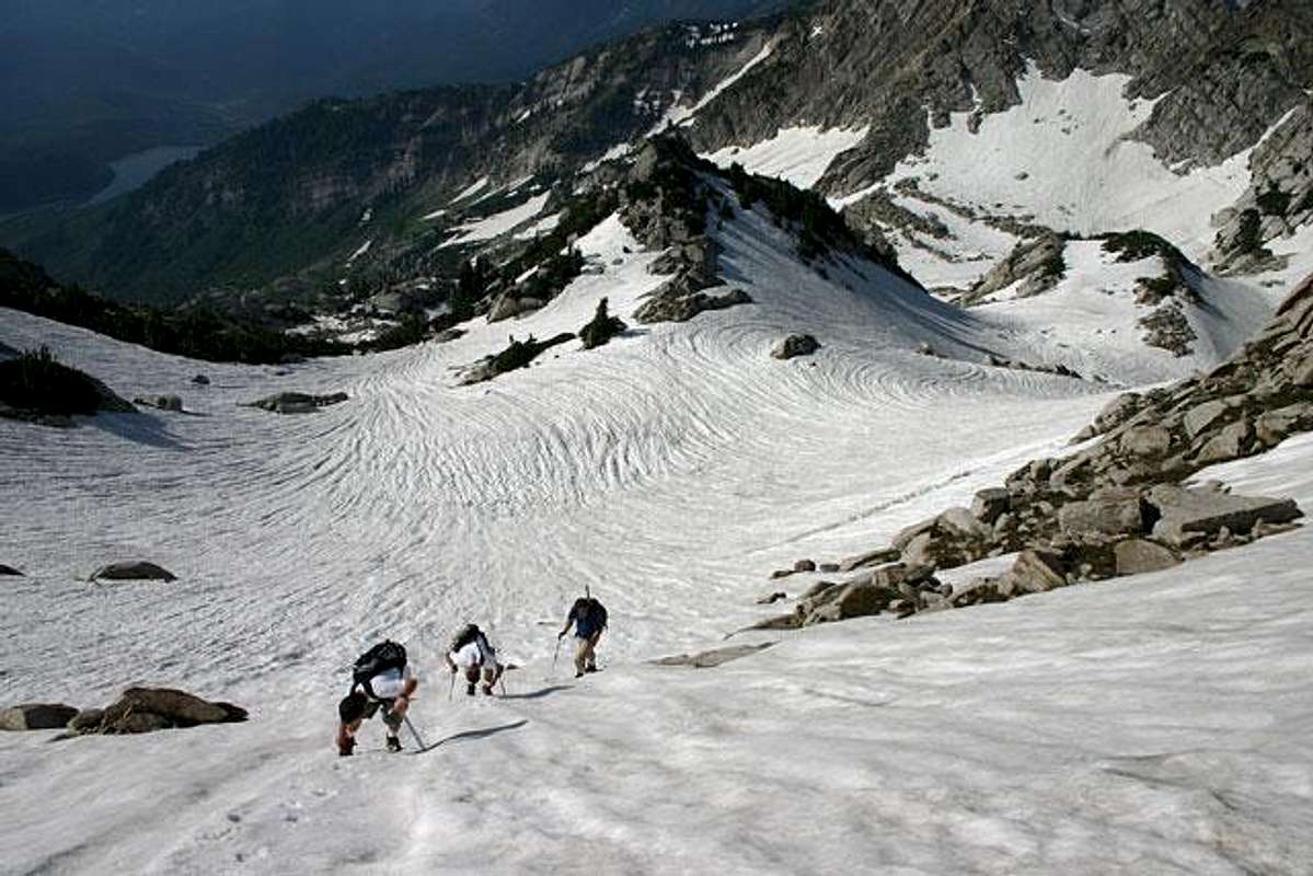
From Silver Lake head directly north toward Silver Glance Lake. Once you are even with the base of the White Baldy's south ridge, travel west across the slope and under the cliffs. You'll find a 40 foot gully that provides the easiest access to the upper basins. The gully is easy Class 4.
The upper section, above the gully, consists of four basins separated by moderately steep slopes (35-45 degrees). There are a number of ways you can travel through these basins. In the middle of the basins there is a large pinnacle shaped like a tooth. We chose to travel to the left of the tooth and around the backside. Once you've gained the last basin, there are a number of ways to scale the headwall to the summit ridge. To the west (left) there is a Class 4 chimney. To the east (right) it is moderate Class 3 scrambling to the top. Notwithstanding the realtive ease of the scrambling (no rope necessary), this is quite a steep section, and a fall would be very bad. In the winter time, this would be quite an ascent. Once on the summit ridge, boulder hop to the top.
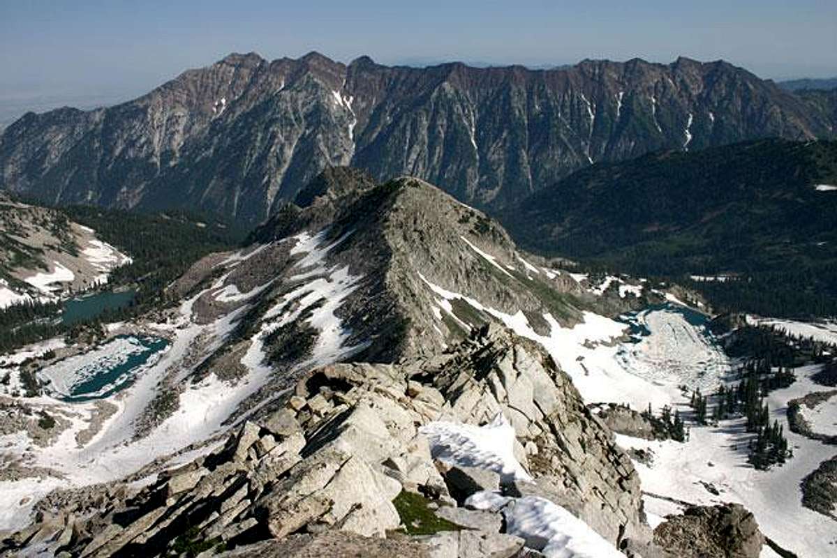
White Baldy is an outstanding summit because of its central location in the Wasatch. The views are some of the best; big mountains all around. White Baldy is also quite rugged, each ridge leading to the summit is narrow with good exposure.
CAUTION: One note of caution. There is a large stream traveling through the upper basins, with a few smaller streams to the sides. In the spring, it's hard to detail exactly where these are under the snowpack. The largest stream is obvious because it is so loud, but the others are sneaky. One member of our team broke through up to his stomach (backpack stopped him), only to find his feet dangling over a 12 foot drop with a stream at the bottom. The incident took place at the beginning of the first basin. After that, we kept to the contours that seemed less likely to have streams and things were normal.
To get to this reservoir, take I-15 to the Highland/Alpine Exit (#287), turn east onto UT-92. Continue east on this highway and you will arrive at the mouth of American Fork Canyon. There is a Forest Service Toll Booth and a $3.00 fee for a three-day pass on the road. Continue up the canyon until you reach the first major fork in the road. Turn left toward Tibble Fork Reservoir. Once you reach the reservoir, go to the east end of the parking lot and you'll find a dirt road that goes straight ahead to Mineral Basin (Snowbird), and an asphalt road that goes left to Granite Flat Campground. Go left on the asphalt road. As you reach the toll booth for Granite Flat Campground, there is a well-maintained dirt road that goes right, up the hill. Follow that dirt road three miles to Silver Lake Flat Reservoir. Drive to the north end of the reservoir and park in the large parking lot. The trailhead to Silver Lake begins next to the restrooms and the information board.
 |  |  |  |  |
Route Description
Hike the trail from Silver Lake Flat Reservoir to Silver Lake (roughly 2.25 miles). The trail is easy to moderate. The views of Mt. Timpanogos, from the trail, are incredible. Silver Lake is one of the more spectacular lakes in the Wasatch and is easy to access, for that reason, it can be fairly crowded on summer weekends so plan on company. If you head 200 yards up the hill to the north, toward Silver Glance Lake, there is a large aspen grove with flat ground and solitude.From Silver Lake head directly north toward Silver Glance Lake. Once you are even with the base of the White Baldy's south ridge, travel west across the slope and under the cliffs. You'll find a 40 foot gully that provides the easiest access to the upper basins. The gully is easy Class 4.
The upper section, above the gully, consists of four basins separated by moderately steep slopes (35-45 degrees). There are a number of ways you can travel through these basins. In the middle of the basins there is a large pinnacle shaped like a tooth. We chose to travel to the left of the tooth and around the backside. Once you've gained the last basin, there are a number of ways to scale the headwall to the summit ridge. To the west (left) there is a Class 4 chimney. To the east (right) it is moderate Class 3 scrambling to the top. Notwithstanding the realtive ease of the scrambling (no rope necessary), this is quite a steep section, and a fall would be very bad. In the winter time, this would be quite an ascent. Once on the summit ridge, boulder hop to the top.
White Baldy is an outstanding summit because of its central location in the Wasatch. The views are some of the best; big mountains all around. White Baldy is also quite rugged, each ridge leading to the summit is narrow with good exposure.
CAUTION: One note of caution. There is a large stream traveling through the upper basins, with a few smaller streams to the sides. In the spring, it's hard to detail exactly where these are under the snowpack. The largest stream is obvious because it is so loud, but the others are sneaky. One member of our team broke through up to his stomach (backpack stopped him), only to find his feet dangling over a 12 foot drop with a stream at the bottom. The incident took place at the beginning of the first basin. After that, we kept to the contours that seemed less likely to have streams and things were normal.
 |  |  |  |  |
Essential Gear
Basic essentials for summer. Axe/crampons for spring, maybe a rope if you are really concerned about the streams and snowpack. Winter time would be amazing and dangerous. You are surrounded by big, steep slopes and walls. |  |  |  |