The Plan
Last week I was surprised to find that my endless hours of scheming, staring at maps, consulting the dear and glorious leader (Beckey) and flat-out drooling had actually produced something tangible: a plan for a scrambling/backpacking trip. I planned it to be five days long, so I was rather limited in who I could sucker into joining me. Apparently I am not as good at convincing people as I might have hoped, because after days of pleading, bargaining, bribing and attempted manipulation I still hadn’t bagged any partners. There was the invariable squabble with my sister over whether I could steal her boyfriend on her days off to go climbing… Much to my chagrin she actually won him over this time, and with an invite to Snoqualmie Lake no less! I decided to go it alone, even if it meant I’d have to tone it down with the peak-bagging.
I researched the scramble routes for five peaks along the crest: Chikamin, Lemah, Summit Chief, Hinman and La Bohn. The plan was to stay as close to the crest peaks as possible for the hike and to check out snow conditions as I decided which peaks to try climbing (I didn't carry crampons or an ice axe). I ran off copies from CAG and Climbing Washington’s Mountains for each peak, versed myself in the route variations and left a detailed itinerary with color-coded indications of where I would be most likely to get in trouble. Cell phone reception was not reliable, but I was able to carry a (heavy) Forest Service Radio along because I would be back on ranger duty for the last day of hiking out the Dutch Miller trail.
Day 1: Glacier Lake; Chikamin
![Huckleberry and Thomson]()
I left Snoqualmie Pass at about 9:30 and headed up the Pacific Crest Trail. I never get tired of this stretch of the trail, and enjoyed the magnificent views and perfect weather up toward Kendall Katwalk. Along the way I met a cotton-clad group of ‘search and rescue bait’ consisting of some clueless adults and three small children. They informed me of their elaborate plan to climb Kendall Peak, traverse the ridge over to Red Mountain and then hike out the Commonwealth Basin, ‘maybe even going over Lundin to Cave Ridge’… Only one of them even had a pack. In as delicate a way as I could manage, I explained to them the folly of their plan, pointing first at the eight year old kids and second to the nasty notch in the ridge over to Red Mountain, explaining the meaning of such things as ‘loose class three’ and ‘the ten essentials’. I advised them to hike to the lakes and maybe come back and try the route themselves another day before subjecting their children to it. I can only assume they heeded the advice, as I didn’t find any mention of them in the Seattle Mountain Rescue report.
![Glacier Lake]()
As I passed Alaska Lake I met a couple of hikers who showed me some rather large, unfired bullets that they had found on the trail. This was a fair bit unnerving, especially considering the recent murder of the women on the Pinnacle Lake trail. I chose to assume that the bullets had been dropped by someone who was just carrying a gun ‘for their own protection’ and continued along a bit more cautiously. I felt more comfortable once I got above tree-line again, as I could see my surroundings better. The temperature rose above 90, but I still made pretty good time across the beautiful Chikamin Ridge traverse, excited to make it to Glacier Lake. I left the PCT after 14 miles (above Park Lakes) to continue about a mile cross-country to Glacier Lake.
![Windy on the summit of Chikamin]()
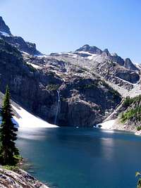
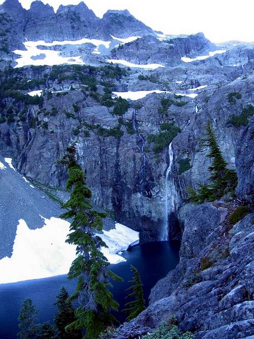
My Jaw dropped when I saw the 300’ waterfall plummeting directly into the lake, and I was transfixed for a good 20 minutes just absorbing the beauty of the lake, its waterfall, Four Brothers, Chikamin and Lemah. When I came to I had pitched my tent in the best campsite on the north side of the lake and was swimming backstroke in the chilly water just below it. This kept me busy for a couple hours before I decided to have a go at Chikamin Peak. From my campsite I scrambled up the blocky talus to the obvious balanced boulder. I opted for the scenic route from there, following the creek almost to the small, unnamed source lake and up the rounded white rocks toward the ridge-crest. This route has a surprisingly alpine feel to it, and was a very enjoyable scramble over ‘Little Annapurna-esque’ rounded slabs to the ridge-crest. The summit gully is loose gravel but you quickly gain the more solid summit blocks. There is a fairly unexposed class three chimney move right before the top. My views to the south were limited by the low-angle sunlight, but I spent a few minutes gawking at Lemah and took a summit self-portrait before heading down the mountain. I was able to do a short, trekking pole glissade (maybe 200’) before down-climbing my route and sacking out for the night to the sounds of the waterfall.
![Glacier Lake and Four Brothers]()
Day 2: Lemah bid; rafting shenanigans
I woke fairly late (about 9:00) and packed up to head down to Spectacle Lake. I decided to look for a cross-country route between the two lakes, rather than go back to trail and hike for several miles when the lakes are less than a mile apart. From the outlet of Glacier, I went downhill along the creek for about 100 meters and found a spot to climb up the ridge. Dropping down the other side to Spectacle there are more rounded rocks and cliffs, so route-finding becomes important. There was one point where I left my pack on a ledge and climbed down a short class three move before pulling the pack down with a trekking pole, but I suspect that there are easier ways to be found. I aimed for the northwest thumb of the lake and actually came out of the bushes at the perfect log to cross the creek. I stashed my backpack, shouldered my summit pack and started up the flat
creek valley.
This is not the preferred route up Lemah, but I chose it in the hopes that I could eschew crampons (the Lemah Creek approach involves climbing a steep snow-finger). There are cairns in the valley, and I proceeded at times along goat trails (you know, the kind they make to lead the salty climbers to their secret licking lair) to the base of a promising gully. The Beckey guide describes a route over this ridge and onto the glacier through a steep scree/heather slope and gully, and I seemed to be at the right place. I clambered up the class 2 gully several hundred feet and was pleased to see that it appeared to angle around a corner to the crest above—seeming like the perfect crossing point below the SE towers… Not the case. The couloir terminates in a craggy little death-notch right below the SE towers (at about 6000 feet); I had no business climbing through this at all, much less alone. I had a snack and poked around to see if I had missed anything, decided I hadn’t and hopped on the snow for the glissade down. I toiled briefly over the idea of finding the correct gully and climbing back up, but decided that in the oppressive heat a swim in Spectacle Lake would be more fun anyhow (this decision was likely influenced by the fact that Spectacle was in view and Lemah was not). The plan for the trip (and a good one for any solo trip) was to climb the mountains only if conditions were perfect, and I had prepared myself for that not being the case; especially on Lemah. I’ll go back another time, hopefully in good company (with crampons) and climb it from Lemah Creek.
Picking up my pack, I started along the north shore of Spectacle. I spent the next hour bushwhacking my way around the cliffy north shore of the lake. Much of this time was spent cursing slide alder and/or being whipped in the face by it. Spectacle Lake has a peculiar shape: it is more like two larger lakes connected by a 50 foot wide, 15 foot deep inlet. I arrived at this inlet and was faced with something of a quandary: from this point one is only 50 feet from trail (across water) but the only land route is another half-mile of nasty bushwhacking. Naturally I did the sensible thing: I stuffed my gear in two large garbage bags, inflated said bags, tied them to my bear-line and swam the inlet with the rope in tow.
It worked beautifully, without so much as a drop of water on my gear; it even cooled me off to boot! I spent the rest of the afternoon swimming in the beautiful lake and enjoying the view of Lemah from this lesser vantage.
Day 3: Escondido High Route; Summit Chief
The next morning I started hiking on the PCT at about 8:30. I passed some boy scouts who had apparently witnessed my rafting antics and thought I was some sort of genius. I made quick work of the nine miles between Spectacle and Vista Lakes, making sure I did the climb up the south side of Escondido ridge before it got too hot. The first time I did this section was in the heat of the day and we hadn’t pumped enough water at the bottom. The upper portion of this ridge has been burned out and gets very hot in the southern exposure, but also offers wonderful views of Lemah and Chimney Rock massifs, as well as Chikamin, Three Queens and Four Brothers. At the top of this long ascent there is the perfect swimming tarn and the site of some great memories from my PCT hike a few years ago. I stopped and swam in the tarn for quite a while and met two older gentlemen that I had given hiking advice to at the Snoqualmie Pass Visitor Center a few weeks before. It was nice to have someone to talk to for a while, and they shared stories of hiking the old Cascade Crest Trail in the 1970’s before the Kendall Katwalk was blasted out.
![Chimney Rock and Overcoat from Escondido High Route]()
From this tarn I left the PCT to trend northwest, passing another of the Vista Lakes before gaining the ridgeline. The ridge is a short (one mile) high route, but it offers some of the best views I’ve seen in the area: Lemah, Chimney Rock and Overcoat Peak to your left, Summit Chief directly ahead and Bear’s Breast, Daniel and Stuart to your right. I walked the broad ridge toward Summit Chief Mountain and stashed my pack at Summit Chief Pass. Pleasant scrambling over broad ledges and snow gave me views of Summit Chief Lake and an unnamed 5160 ft lake that must not get much sun, as it was still mostly frozen July 27th.
![5160 Lake below Summit Chief]()
Continuing on, I came to a very steep, shaded snow gully with a very unpleasant looking runout. I probably could have managed this with my poles but I decided against it, keeping an appropriate level of caution because I was alone, and kicking myself for not bringing an ice axe. From the snow gully I back-tracked slightly and decided to explore the possibility of scrambling up and over the false-summit to emerge in the snow-field below the summit block.
![from near my turn around point on summit chief]()
I found some down-sloping class 2 slabs and scrambled up to the fantastically exposed ridge-crest. The wind was absolutely ferocious on the ridge, and after a couple class three moves it wasn’t looking safe to go over the false summit and I’d had my fill. I turned around at that point (about 6400’) and carefully down-climbed to the more pleasant ledges before traversing back to my gear. The normal approach route from the northwest of the frozen lake appeared to be mostly snow-free in the crucial parts, and I considered trying it from that direction early the next morning. Climbing down from the ridge to Summit Chief Lake was kind of difficult with my cumbersome pack on, especially to get to the outlet end of the lake where I camped. The only flat place at the lake was a patch of heather, so I felt pretty guilty as I pitched my tent (sorry Heather).
Day 4: Bushwhack of Death, Williams Lake, Leah brings food!
I decided not to have another go at Summit Chief, as I didn’t want to wait around for the snow to soften up, and I had some cross country route-finding to do before meeting my friend Leah at the Dutch Miller Gap sometime around noon. Dropping down the headwall below the lake proved to be quite the undertaking with my large backpack: several times I would throw the thing over a ledge, climb down, throw it over another, climb down, repeat... I found a spot in the snow where it looked like a bear had played around and cooled off: marked by playful tracks and rolling marks (picture didn’t turn out… more on that later).
Finally getting down into the trees, I began contouring along the west side of the valley below some rocky out-croppings (about 4600’), making for the Waptus River trail to the north. This section was only about 1.5 miles long, but took close to two hours. At times I would find myself suspended upside-down in slide alder, wriggling to get free and coming up with some pretty fancy streams of expletives. There was a difficult Creek Crossing followed by more bushwhacking and I finally popped out onto a steep meadowy slope and a last rocky ridge. Rounding the ridge I made a fall-line through the trees for the trail that I knew was below me. I emerged haggard, filthy and scratched (probably with a wild look on my face, too) about a quarter-mile beyond the last switchback coming up from Waptus, which is about what I intended. Even with the brush and slide alder I would do this again, as it cuts off about 10 miles and saved me going down and then coming back up 2200’ since I was headed for Dutch Miller.
![Lake Ivanhoe]()
Shortly along the trail I found a nice little blue pool in the creek, and within seconds I was fully immersed in it, happy to wash off the sweat dirt that I had accumulated. Feeling refreshed, I hiked along the North side of beautiful Lake Ivanhoe before passing through the Dutch Miller Gap and hiking the two miles down to Williams Lake. Leah arrived at the lake about 45 minutes after I did, and she quickly became my favorite person as she listed all of the delicious food that she brought (I did this trip without a stove—I was pretty tired of Clif Bars). We decided to put off Hinman and La Bohn Peak for the next day and spend the afternoon wandering around the lake and eating (who could refuse?).
![Williams Lake and Little Big Chief]()
From the Williams Lake we noticed that there is a high valley just to the west of Summit Chief that still had a fair amount of snow in it. Leah wanted to go size up the valley for skiing, and within 20 minutes we were standing at the bottom of the precipitous west face of Little Big Chief, awestruck by the incredible peaks above us. We wandered to the southern end of the valley and watched some baby marmots for a bit before heading back to camp for curried lentils and salmon.
[img:211961:alignright:medium:]
Day 5: Rain; No Hinman, La Bohn
We woke up to find that a pretty strong marine push had moved in overnight. With our proximity to the crest it was raining slightly and showing no signs of clearing. We both decided that it would be a bad idea to go up on the Glacier in the fog and so we put off La Bohn and Hinman for another time. The hike out was a lazy one and we arrived at the Dutch Miller trailhead at 3:00 to drive for another 1:45 to get to pavement. The Dutch Miller trail has undergone a lot of improvements this season and is free of windfall. The Forest Service plans to gate the road at Dingford Creek this Fall, so hit it while you can! (or else just hike an extra 7 miles from Dingford)
When I loaded my pictures, I was terribly disappointed to find that my camera shutters had failed to open all the way for over half of my pictures from this trip :( The camera had already been damaged by my glissading antics, and this latest problem was caused by a fir needle that had lodged in the outside shutters


Comments
Post a Comment