
|
|
Mountain/Rock |
|---|---|
|
|
41.73330°N / 21.51660°E |
|
|
Hiking, Sport Climbing |
|
|
Spring, Summer, Fall, Winter |
|
|
8333 ft / 2540 m |
|
|
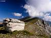
Overview
 Solunska Glava (2540m) and its eastern face
Solunska Glava (2540m) is one of the highest peaks in Macedonia. It is highest peak of several massifs in the central part of the country, south of capital Skopje. These three massifs are Dautica (2178m), S of Solunska Glava, Karadjica (2472m), on the NW and Jakupica (2112m), on the SE. Between Jakupica and Dautica is Babuna river valley. One might say that Solunska Glava is highest peak of all three crests because there isn’t distinctive border between them and they touch at Solunska Glava. Among themselves these 3 massifs have many peaks above 2000m. One more mountain belongs to this group of mountains. It is Golesnica (1935m), on the NE, but it is well separated from Jakupica and Karadjica.
While it is difficult to draw borders between these 3 mountains and determine to which one Solunska Glava belongs, it is easy to determine borders of the whole group. On the N is river Vardar valley and capital Skopje. On the E along the group also river Vardar flows. In its valley Veles town is placed, which is main gateway to climb Solunska Glava. On the S is river Babuna valley, Babuna mountain and Prilepsko Pole field. On the W river Treska valley separates the group from Celoica (2061m) and Suva Gora (1748m) mountains.
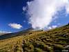
As mentioned in first part of this section, Solunska Glava is highest peak between 3 massifs. It is beautifully shaped cone which has two different faces. On the south, west and north its slopes are mix of grass and rock, at the upper grass layer, which means grass isn’t juicy and high but scarce. These sides rise quite steeply above high grassy plateau placed between Solunska Glava and Dautica and Karadjica massifs. Plateau is closed by grassy peaks from all but western side where passage between Dautica and Karadjica mountains is. Eastern side of Solunska Glava is completely different. It is mighty and imposing amphitheater that is rising almost 2000m above Babuna valley. Above the forest line is wide, beautifully white, eastern face that is some 1000m high and almost perpendicular. Solunska Glava dominates the amphitheater, naturally. South of the summit edge of the face gradually descends towards Dautica massif while towards NE it descends towards Jakupica massif, making semi circle above the Babuna valley. Below the face, at around 1500m, in deep beech, spruce and fir forests, is source of Babuna mountain creek which later turns into the river. Creek descends steeply and has several waterfalls.
Unfortunately the very summit of Solunska Glava is unapproachable! On the summit is wired military object with tower and weather station. Gate of the compound is at around 2505m and is guarded by armed soldier. Army stuff isn’t unfriendly and if you ask they will bring you water and give a peak stamp if you are collecting Macedonian mountains or want a memory in your mountain diary. Of course, because of the object macadam road reaches the summit from the north but it is suitable only for 4x4 terrain vehicles.
Solunska Glava means Head of Solun and Solun is Slavic name for Greek town Thessaloniki. It is said the on clearest of days it is possible to see Solun from the summit and that how the name of the peak was forged.
There are two normal approaches to Solunska Glava. Northern approach begins at capital Skopje. Asphalted road leads some 35km via the Dracevo and Kolicani to Aldinci village. From there it takes 2h to Karadjica hut and another 5h to the summit. Southern approach begins at Veles town. Asphalted road leads from Veles to Bogomila village some 43km. From Bogomila it takes 4h to Ceples hut via Nezilovo village (further 7km of asphalt from Bogomila). Hut can also be approached using macadam road from Nezilovo. From the hut it takes 3.30h to the summit.
View from the summit is very wide. It covers almost all Macedonian mountains and is uninterrupted in all directions.
 |  |  |  |  |
Hike Advices
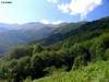
I only saw southern approach so can’t really compare it to northern one but one thing is certain, you can’t see magnificent eastern face of Solunska Glava and amphitheater above Babuna river valley from northern approach and that is highlight of the entire mountain. Beside that fact southern approach seams to be much more diverse. Up to Ceples hut you hike by the water and bit higher up through beautiful beech forest. Once above it, hour from Ceples hut, views are amazing. From what I saw from the summit northern approach is one long drag up the long open slopes, without any special attractions. Also I can confirm that managers at Ceples hut (mountaineers from Veles) are great people.Solunska Glava can be climbed in a day, especially if you drive to Ceples hut, but road is not suitable for low cars, on spots it is bad. Asphalt reached Nezilovo village in Babuna river valley, you can leave a car there. If you are coming by public transportation then final stop for you is Bogomila village, 7km before Nezilovo. To climb Solunska Glava and descent back to Bogumila in a day is tough bite because it is long and there is 2000m of ascent and 2000m of descent. In that case reach Ceples hut during the day, visit Babuna river source in the afternoon and sleep over. In the morning climb Solunska Glava and return to the valley. This is better option even for those with cars because good weather usually on holds for few brief morning hours so to catch it you have to start from Ceples early in the morning, at dawn is best. After 10am summit is often in clouds.
 |  |  |  |  |
Getting There
By PlaneAir gateway to Macedonia is capital Skopje. More info about flights find on the site of Macedonian Airports.
By Bus
Buses from Skopje lead to Veles. From Veles there is a bus to Bogomila village, trailhead for southern approach. Don’t know how far up the northern approach busses go.
By Train
Bogomila is train station on the Skopje – Bitola railway.
By Car
Northern approach -> Skopje - Dracevo - Kolicani – Aldinci: 35km
Southern approach -> Skopje – Veles: 49km, Veles – Bogomila: 43km, Bogomila – Nezilovo: 7km. At Nezilovo asphalt ends but it is possible to reach Ceples hut via macadam road, it is additional 14km. Road is not good on places so if you car is quite low don’t even try.
 |  |  |
Maps
There are no mountaineering maps in Macedonia. Road maps are good but there isn’t much help from them in the mountains. Here are two relief maps, one of wider area around Solunska Glava and the other zoomed of closer area. I added the southern route and path to Babuna source so that you have some picture where paths go.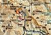 |  |
When to Climb
Solunska Glava is high peak with harsh climate. Winters are cold and snowy with strong winds. Full equipment is necessary then. Huts are closed except if you arrange it to be open with managers. Summer is usual time to visit Solunska Glava, from July to September. Start early to catch good weather because daily cloud development is usual routine. Summit is often in clouds then as warm air rises up the huge eastern side and clouds condense on the ridge. This process begins as soon as Sun raises temperatures in the valleys. I guess that September has much stable weather than summer because temps in the valleys are lower. |  |  |  |  |
Mountain Conditions
Thanks to the summit meteorological station weather on Solunska Glava is well known. Data and forecast can be found on various weather sites.Russian weather server provides best current data while forecasts can be found on Wunderground, although I noticed that their temperature forecast is way too high and seems accurate for the valley not for the summit. Best weather site, Weatheronline, gives accurate forecast and current data for capital Skopje, which is quite close to the north.
 |  |
Where to Sleep
Ceples hut (1450m) is placed along the southern Solunska Glava approach. It stands on the open slope among beech forests which is covered by dense green carpet of fern. High grassy peaks of Dautica massif tower above while Solunska Glava is not visible. View is open towards south. Ceples hut is traditionally built house with one floor. In group bedrooms of up to 10 beds there are 40 places. By the hut is kitchen and dinning room where you can prepare your own food. You can also arrange meals with managers for larger groups but it has to be in advance. Hut has electricity and is accessible by car via macadam road that ascends from Bogumila via Nezilovo village. Hut is open during the summer season.Karadjica hut is placed along the northern approach to Solunska Glava. Haven’t been there so don’t know much about it except that it has 40 beds, electricity and is open during summer season.
As far as I know camping isn’t forbidden. Except the space in front of the hut other suitable place to erect a tent is beautiful meadow, 1h from Ceples towards Solunska Glava. Meadow is close to the forest line and has amazing view towards Solunska Glava. There is source on the meadow which never dries.
Velebit - Oct 18, 2005 9:46 am - Hasn't voted
Untitled CommentThank you for this information! I'll put it in the main text soon.
punkrunner - Oct 18, 2005 7:59 am - Hasn't voted
Untitled CommentNew hut is in building phase these days at Ceples (1450m) and will be ready in sping next year (2006). It will have about 30 beds, central heating, few bathrooms.
The road from Nezilovo to Ceples now is much better and you can go ther by normal car.
Velebit - Oct 18, 2005 9:46 am - Hasn't voted
Untitled CommentThank you for this information! I'll put it in the main text soon.