
|
|
Route |
|---|---|
|
|
47.09070°N / 12.31155°E |
|
|
Hiking, Mountaineering, Ice Climbing, Mixed, Scrambling |
|
|
Summer, Fall |
|
|
One to two days |
|
|
Basic Glacier Climb and in the upper part steep scrambling, UIAA I-II on some parts |
|
|
Getting There
For the south - east approach you have to follow the road until Matrei, then the valley Virgental to the village Hinterbichl, 1329m. Here you park the car by the houses in the village or you drive some 500 meters from the village and then on the crossing turns to the right and over the road you reach the larger parking place near the stone-pit. You can take a taxi to the hut Johannishütte, 2121m or you simply walk by foot all the way to the hut over the macadam road through the beautiful valley called Dorfertal.. One nice possibility is also with the bike.Route Description
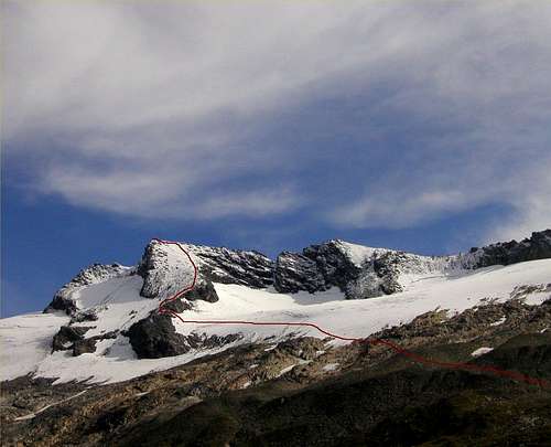 Grosser Happ, 3350m and its west side. You have to find the best passages to the summit.
From the hut you follow the signposts for the hut Essener - Rostocker all the way over the marked route. The marked route has number 913. Over the sout - east slopes of Kleiner Happ, 2855m and Grosser Happ, 3350m you will reach a pass Türmljoch, 2790m. From here you have to descend almost 300 meters to the altitude around 2500 meters.
From here you turn to the north direction and over the best passages you reach the upper grassy and rocky plateau below the glacier. From here you go just below the glacier as far you can. When become too much steeper you step on the glacier and around the crevasses you reach the large steep west slope that falls directly from the summit of Grosser Happ.
Just before you come on this slope you have to climb a short passage around UIAA I-II from the glacier. Now you have to reach the summit all the way up over the steep west slope. Be careful in icy and snowy condition. You have to find the best passages on your own.
You descend by the same route or by the route to the hut Essener - Rostocker, 2208m. From the hut you will need for the ascent around 3-4 hours.