
|
|
Route |
|---|---|
|
|
48.84861°N / 121.1628°W |
|
|
Mountaineering |
|
|
Summer, Fall |
|
|
One to two days |
|
|
Class 2+ |
|
|
Overview
I am creating this Route Page as a service to my fellow peakbaggers. I have known MANY peakbaggers who have failed on the Southwest Rib route mentioned on the main page for this peak. This is not surprising, as the Southwest Rib route had been considered the primary route for many years and there had been more information available for that route than others. But the Southwest Rib route is somewhat technical, having a number of crux moves and situations... including creek fording, bushwhacking, routefinding issues, and Class 4 moves/sections, among other obstacles. It is also a longer route than the next-best alternatives. I am hoping the alternative "South Ridge" route can be used to help my fellow peakbaggers achieve a higher rate of success on what is a wonderful, highly recommended peak to visit.
Save yourself some grief and maximize your opportunity for success. Go the South Ridge route.
What are the advantages of the South Ridge route? It is a shorter, straightforward ascent, and mostly non-technical. Plus, as a south-facing ridgeline approach, this route thaws out sooner than other routes.
What are the crux moves/sections for the ascent? Steep forest terrain. Class 2+ scrambling in higher terrain near summit.
What about primary seasons and cornice concerns? The main page mentions (and shows) cornices that might be potentially troublesome for the South Ridge route. However, if you go between July-October those concerns should be largely if not entirely eliminated. But even if you attempt this route earlier and/or encounter cornices on the north-south ridge near the peak, after 6000' there are multiple options for attaining the ridgeline while avoiding cornices, whether directly or by traveling around the cirque above Lake 5472.
In my opinion, the South Ridge approach should start being considered the standard approach for this peak.
Getting There (Trail Travel)
Start at the Ross Dam Trailhead (2120'), located along Highway 20. Any street-legal vehicle can reach this trailhead. Have a Northwest Forest Pass (parking pass), if parkign at this location. If you hike from this location, the trip will be ~32 miles roundtrip with ~10,000' cumulative gain. Or if you reserve a boat trip to/from Big Beaver Camp, the trip will only be ~18 miles roundtrip with ~6600' cumulative gain.

If hiking all of the route from Ross Lake Trailhead, hike one mile down the trail to the road below, then following the road and signs to Ross Dam. Walk across the dam (1600'), and take a few moments to looks at each side and marvel at this engineering accomplishment. Once at the other end of the dam, the trail veers right and parallels above the west side of Ross Lake. After three miles from Ross Dam, pass by the intersection with the Pierce Mountain/Sourdough Mountain Trail (2100') on the left. Continue straight on the trail. A couple of miles further, Pierce Creek Falls will offer a brief water source but further downhill the trail will cross a larger stream. There will also be water at Big Beaver Creek.

After three miles from the Pierce/Sourdough Trail junction, cross a large bridge over Big Beaver Creek and then soon reach the Big Beaver Trail junction (1600'). From the trail junction, turn left (west) onto Big Beaver Trail.


Hike along the trail for 5.1 miles until reaching Thirtynine Mile Creek (1720'), which has a horse campground on the east side (that you pass first) and then a tent campground on the west side.
ADVICE: Fill up your water containers here, as this will be your last great water source (but for other water sources up higher, see "Essential Gear" section).


Route Description (Off-Trail Travel)
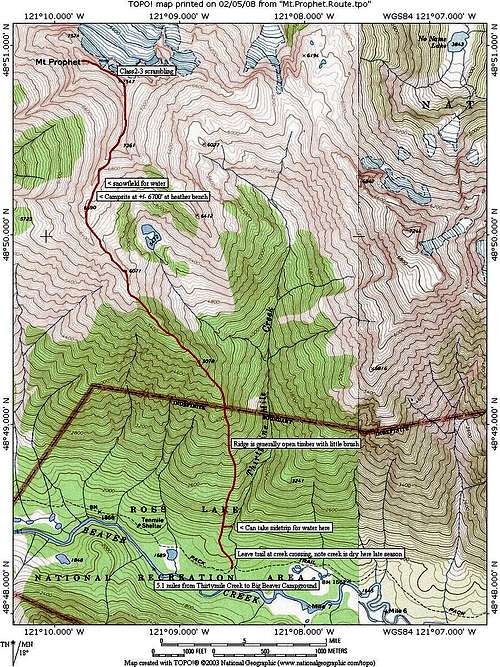
Shortly after passing the west side of Thirtynine Mile Creek, leave the trail and head north uphill. Leave the trail anywhere between the west side of Thirtynine Mile Creek and the "Thirtynine Mile Creek Camp" marker post. Find what you think seems like the best way up; there is not really a wrong way, just go up. There might be a little easy brush to go through but just keep heading up, keeping the creek to your ascender's right side while trying to funnel towards a ridgeline. The ridgeline will become more defined within 300'-400' of gain from the trail. In the first 1.25 miles after leaving the trail, you will be in steep, mostly open forest (but no views) for the first 3100'+ of elevation gain. The steepest forest/ridge sections are between 2000'-2400' and between 4000'-4400' (but several other sections are steep, too); just take your time. Albeit steep in places, these sections are just walkups but use caution to not lose your footing. Going up the southeast ridge is generally straightforward. Yes, ascending 3100'+ is a lot of elevation gain for 1.25 miles but it is all contained on a forested ridgeline and the remaining 2.5 miles to the summit will be far more modest.


While ascending the southeast ridge, once you reach Point 5078 you will think you get your first view of the mountain... but you will actually be looking at Point 7361 (with true summit hidden behind it). There is also a good view of Genesis Peak, located to the east.


From here, the ridgeline walk will become more gradual and open as you ascend, and the views really start to open up. Once at Point 6071, your approach towards Point 6690 becomes more obvious. You also start getting views of Lake 5472, located below the north side of this location. Walk along a series of large meadowy ledges and some talus to reach Point 6690. It will not be until at/near Point 6690 that you will see the true summit of Mount Prophet.


The views from this location and beyond are awesome. From Point 6690, turn north along the north-south ridgeline and ascend to Point 7361, then continue north to Point 7547, and then continue west a short jaunt to the true summit of Mount Prophet (7640'). There are some Class 2+ scrambling in these sections beyond Point 6690 but nothing majorly technical. The summit is approximately 3.75 miles (one-way) with 6200' cumulative gain from Thirtynine Mile Creek Camp, but half (3100'!) of that gain happens in the first 1.25 miles and the last 2.5 miles are far more modest, overall.
Essential Gear
Consider having a GPS for this approach as a must, not for the ascent but for the descent. The ascent from Thirtynine Mile Creek Camp is somewhat straightforward ("follow the ridge!"). However, during the descent once back in the trees below Point 5078 until near the Big Beaver Trail, there are multiple similar-looking spur ridges that are encountered. Having a GPS track log with you will help keep you on the correct ridge.
The biggest issue with this route might be the lack of water sources. There is no running water along the route beyond Thirtyninemile Creek/Campground. However, sources are still available in the higher terrain. Even in mid-to-late August on an average snowpack year, there tends to be plenty of snow patches around 6500'-6800' from which someone could thaw water if needed. As an alternative, a determined summiter might be willing to descend ~600' to Lake 5472, which always has water.
Hiking poles are highly recommended, due to the steep terrain of the route.
Camping
Potential backcountry camping spots start to appear at and beyond Point 5078, with arguably the best-looking spots (with minimal-to-no veggie disturbance) at the saddle immediately beyond Point 6071 and near Point 6690. There is a great rock bivy site at Point 6690, too. With that said, the National Park Service now forbids backcountry camping in the area. The best case, legal scenario is to reserve a campsite at Thirtynine Mile Creek Camp, camp there, and then go off-travel from that starting point. Potentially, a summiter could reserve a campsite at Big Beaver Camp or Pumpkin Mountain Camp, and then make the trek from one of those locations without adding overall extra hiking distance to the journey. Or someone could reserve a campsite at Luna Camp and then backtrack several miles (but this will add eight miles roundtrip). If a campsite at Thirtynine Mile Creek Camp is not available, a determined summiter might reserve a campsite at one of those other official campgrounds but then attempt to backcountry camp at one of the great backcountry locations mentioned above... but that would not be recommended.
External Links
A great downloadable GPS track for this route was created by Bob Bolton, found at this link:
https://www.peakbagger.com/climber/ascent.aspx?aid=344581