
|
|
Route |
|---|---|
|
|
39.07080°N / 106.9886°W |
|
|
Download GPX » View Route on Map |
|
|
Scramble |
|
|
A long day |
|
|
Class 3 |
|
|
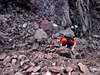
Introduction
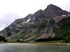 |  |
Approach from Maroon Lake TH-Class 2
South Ridge Route-12 miles and 4,566-ft round trip.Starting at Maroon Lake TH (9,580-ft) follow the wide “West Maroon Pack Trail” as it gradually climbs the aspen laden benches above Maroon Lake. Continue about two miles to Crater Lake where you will come to a junction in the trail. Take the “West Maroon Trail” and follow it another 1.5 miles to a place where the trail actually crosses West Maroon Creek. Do not cross the creek but look sharp to the right for a spur trail heading up and out of the creek drainage onto Maroon’s southeast slopes. This trail is the start of a 2,800-ft slog up to the real south ridge of Maroon Peak. The trial is steep and will test your enthusiasm for your planned day. Follow this trail as it ascends and traverses southwest toward Maroon’s lower, grassy, rounded south ridge. This relentlessly steep trail will gain this ridge and follow the ridge crest to a notch in the real south ridge of Maroon Peak. This shallow notch is at 13,300-ft and it is obvious when you arrive for the view of the rest of your route is daunting. Let the Class 3 fun begin.
 |
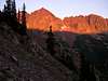
The last 1000-ft-Class 3
Initially, climb out of the notch and follow the narrow ridge as it delivers you to your first set of cairns. The idea from here on out is to keep your eyes peeled for cairns. Most of the cairns placed on this route will help you; I really don’t remember too many that threw us off the real route. Traverse an intricate series of ledge systems that keeps you at around 13,300-ft. Using mini-gullies and small chimneys the route continuously crosses out over loose rock ribs and deposits you back into more loose gullies.Your first gully is probably the most dangerous section of the hike. When you arrive you will notice that it is steep and plugged up with large balancing talus, avoid this loose stuff by ascending on the far right or left of the gully on more solid ground. Do not hike up the middle of this stuff. I recommend going one at a time up this one and having anyone without a helmet to go first, unless you don’t trust the person, then you make sure you go first or get the hell out of the way.
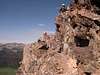
After a quarter mile of traversing the route comes to a more pronounced gully filled with loose rock and mostly sand-like scree, great for descending but a nightmare to ascend. Ascend this gully for about 300 vertical back to the ridge crest. From the ridge crest traverse back out over another rib and you can finally see the true south face of Maroon Peak and its summit about 400 vertical above you. This is another deflating view, keep going. Traverse back out onto the south face and take the path of least resistance, following cairns and using vertical steps and more ledge systems to ascend back to the ridge crest again. From here you can peer down onto Maroon’s huge east face. Continue your familiar theme of loose ledges and traversing for an ascent of 200 vertical to finally reach the summit. The views are spectacular, enjoy.
As I recall there were about 5 or 6 traverses out onto the south face, most of them crossing over rock ribs and around blind corners depositing you into loose gullies. These corners are usually cairned. The traverses rarely gained much vertical, for the gullies and the vertical rock steps helped get you up the mountain.
 |  |  |  |  |
chuckallen - Aug 15, 2004 3:04 pm - Hasn't voted
Route CommentMy group took a different line than that depicted in your very nice route photo. Instead of dropping down into the bowl and upclimbing the entire loose gully, we followed what we believe to be the standard route which goes to the right of the two rock towers at the right of the photo and then turns left, following cairns to a ledge. The ledge ends at a chimney. We climbed up the chimney, taking the left split inside it, and then followed ledges high into the into the gully on the right side of your route photo. We then followed ledges high across the face, around a nose, and eventually entered that loose gully half-way up. As you noted, the less of that gully the better.
Is there any chance I could get permission to use your route photo, without route and with credit, to depict our route on our web site, http://maroonclimb.com/ ? If so, please e-mail me at cea8000@aol.com.
Thank you!