-
 977 Hits
-
 77.48% Score
-
 8 Votes
|
|
Mountain/Rock |
|---|---|
|
|
38.48229°N / 119.30132°W |
|
|
Mono |
|
|
Hiking, Scrambling |
|
|
Spring, Summer, Fall, Winter |
|
|
11360 ft / 3463 m |
|
|
Overview
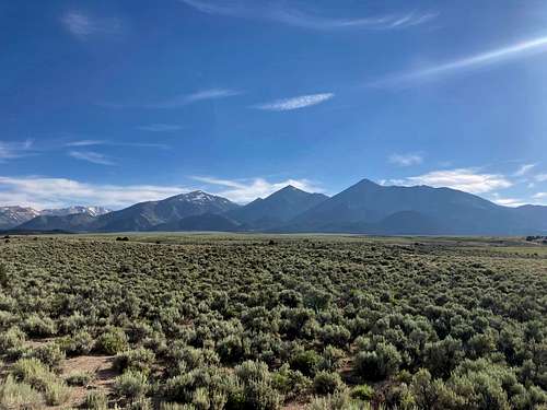
South Sister is the southernmost and highest of the "Three Sisters" within the Sweetwater Range east of the Sierra Nevada. No, these are not the Oregon volcanoes - these are a series of three peaks (East Sister, Middle Sister, and South Sister) that skirt the desert and Great Basin biomes. These peaks are immediately recognizable through the distinct summits rising north of the main Sweetwater massif, providing a striking skyline when viewed from CA-182 north of Bridgeport.
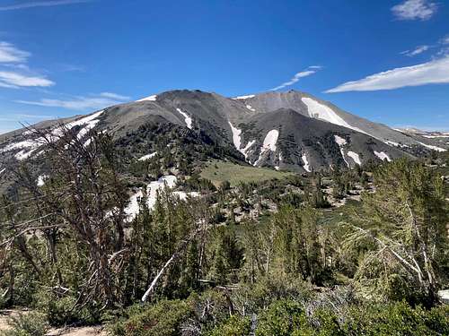
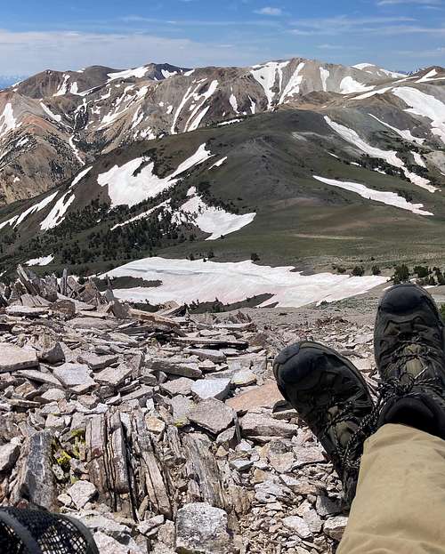
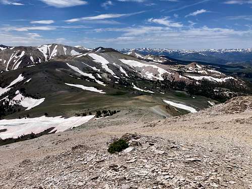
Unlike the comparatively wooded East and Middle Sister, South Sister shares much of the same geology as the range's high point, Mt. Patterson. It is defined by the geomorphological "fellfields" on the summit. Fellfields are alpine landscapes upon which the confluence of extreme freeze-thaw cycles, consistently high winds, and particularly porose soils (such as those you'd find in volcanic rock) prescribe an ecology unsuitable to plants yet are still unlike most deserts. You'll find plenty of close-to-the-ground perennials, including members of the polemonium genius and plenty of lupines.
The rocks are primarily a mix of granitic and volcanic rocks. The volcanic geology here is quite different from the crumbly metasedimentary rocks that define Reynolds Peak and Virginia Peak; instead, these are much more porous and rounded as opposed to those other two peaks' slate-like fracturing.
East Sister and Middle Sister are much more wooded compared to South Sister. A curious trend can be seen in the thick mountain mahogany that blankets the southern slopes of the other peaks that thins out almost entirely upon hitting South Sister. South Sister's high altitude (>11K feet) relative to East and Middle Sister pushes it right into the desert alpine territory in which scrubbier flowering plants thrive.
Outside of the beauty, South Sister has a few things for the pursuant peakbagger. It's the 17th-highest of the 61 non-Sierra peaks over 10,000 feet. It's the 3rd highest Tahoe Ogul peak - only behind fellow Sweetwater peaks Mt. Patterson and Wheeler Peak (and you can certainly hit all three in the same day). It is also one of the 334 mountains described in Andy Zdon's "Desert Summits" book, albeit not a part of the Desert Peaks Section list from the Sierra Club.
Getting There
There are two primary trailheads/starts for climbing South Sister, as described in the "Routes" section. The East/Middle Sister Traverse and Northwest Slope both start from Risue Canyon Road, north of the Sisters proper. The traverse from Mt. Patterson starts from near Lobdell Lake due west of Mt. Patterson.
Risue Canyon Road:
Risue Canyon Road is a dirt road that travels from NV-338 to near US Route 395. Road quality varies; from the west, it's pretty difficult to safely travel in a vehicle without 4WD. From the east, the road is much more manageable for 3-4 miles from NV-338, which just so happens to correspond to the distance needed to hit the northern approach.
The western part of the road is accessible by 2WD vehicles with moderate to high clearance. I was able to access the northern approach via Little Smith Valley with a base model 2WD Jeep Compass. From my climb in late July 2023, I would rate this road similar to the conditions of many northern Sierra dirt roads around and north of Lake Tahoe, such as the drive to Fordyce Summit from I-80.
Getitng to the east access point is as simple as driving approximately 25 miles north of Bridgeport and crossing over the Nevada border. There is a small sign that points out Risue Canyon Road right before the turn-off. Exit, then follow Risue Canyon Road for approximately 3 miles until hitting two L-shaped bends, the second of which has a cattle road that leads southwest toward Little Smith Valley. Park anywhere that's responsible; there are plenty of dirt turnouts.
Lobdell Lake:
If you're doing the traverse from Mt. Patterson, then you will park near Lobdell Lake. There's usually plenty of parking, though with the caveat of occasional swamping depending on snowmelt and rainfall.
Around 2.5-3 miles east of the junction of CA-108 and US Route 395, turn north on Burcham Flat Road. This is a well-graded dirt road accessible by all vehicles. After around five miles, turn east (i.e. right) onto Lobdell Lake Road, also identified by "32067" on USFS topo maps. This road will take you past Lava Springs (an excellent site for filling up water, though mind the nettles) and wind its way up to Lobdell Lake itself.
Routes
There exist three main routes to climb South Sister: 1) traversing from East and Middle Sister; 2) scrambling up the northwest slope; and 3) traversing from Mt. Patterson. Each route has significant pros and cons, owing to the relative isolation (not topological) of South Sister compared to other mountains in the Sweetwaters. Of these, the traverse of the other Sisters is most highly recommended for a rewarding and challenging day.
| Route | Distance | Elevation Gain | YDS Class |
| Traverse from East and Middle Sister | 14.5 miles | ~6,100 feet | 2 |
| Northwest Slope | 13-14 miles | ~4,000 feet | 2 |
|
Traverse from Mt. Patterson (includes Mt. Patterson + Wheeler Peak) |
~22 miles | ~6,000 feet | 1 (road hike) |
Traversing from East and Middle Sister:
Both the most common and the best route, this traverse incurs traveling from north to south over East Sister, Middle Sister, and South Sister, thereby progressively gaining more elevation with each summit. This route begins right south of Risue Canyon Road, occurring after two ninety-degree bends when driving from the east. These directions assume starting right off the cattle road described in "Getting There".
- Travel south for approximately 2.5 miles on the cattle road through Little Smith Valley. This will take you over a cattle fence and an old corral within the Humboldt-Toiyabe National Forest. The cattle road gradually steepens as it winds its way up the valley, getting more rutted along the way.
- When in view, scramble up the northwest slope of East Sister. Aim for the saddle between East Sister and the rocky northern promontory so you miss some of the steeper scree/sand. This is all rough cross-country travel; i.e. easy Class 2. The saddle is at approximately 9700-9800 feet.
- After gaining the ridge, head south toward the East Sister summit, gaining apprxoimately 600 feet of elevation gain in around 2000 horizontal feet. You might have to start weaving through mountain mahogany on the way up. Yeah, get ready for that.
- Continue south through extremely thick mountain mahogany and begin the rise up to Middle Sister. If you stick to the large rocky spine jutting out of Middle Sister's north ridge, then you'll find it's a lot easier than trying to manage the sand/dirt and trees.
- Descend from Middle Sister along the southwest ridge. You'll want to stick further west than you initially think, as trying to go directly south will take you through the absolute thickest bushwhacking I've ever done on a California summit in or east of the Sierra range. Seriously, it's ridiculous - don't be surprised if you army crawl.
- Circle to the west of a brief 100-foot rise that stands in front of you and the true saddle between Middle Sister and South Sister.
- Scramble up the sandy northern ridge that takes you to the northeast ridge of South Sister. Compared to East Sister and Middle Sister, this is actually the easiest part of the entire traverse. It's steep, but the footing is much better, there are no trees, and said steepness doesn't last too long.
- After 11200 feet, make your way to the west and scramble up the second of the two rounded, granitic summit blocks.
- Look south and enjoy some of the absolute greatest views of the Sweetwaters - and desert peaks in general!
- Descend via the very steep and very sandy northwest slope, which appears as a use trail on some topo maps (i.e. GaiaGPS's base map).
- Meet up with the cattle roads north of the two lakes, turn north at the crossroads, and walk back on undulating cattle roads and old forest service tracks on your way back to Little Smith Valley and Risue Canyon Road. The distance back to the road from the lakes is approximately 6 miles.
This is an excellent way to back all three Sisters, which will serve the rockhound well if they're pursuing the Sierra Club's Great Basin list, the Sierra Club's Desert Peaks Section, and/or the Tahoe Oguls. Nice!
Northwest slope:
This basically follows the same route as the traverse, except backward. The reason why this is not as recommended as the traverse is simply because it's a lot more boring and the slope proper is an absolute sufferfest. You gain approximately 1500 feet of elevation in less than 5000 vertical feet - which doesn't sound too bad, until you remember most of that is sand. One step forward, half-step slid back - that kind of deal.
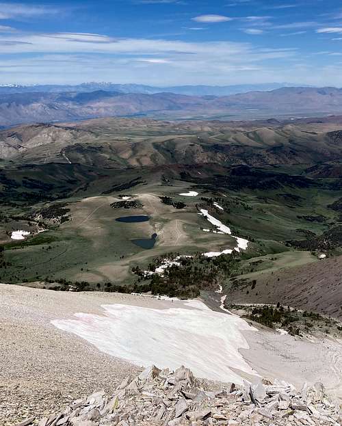
- Starting from Risue Canyon Road, follow the same cattle road/old forest roads described above, except continue on them and don't go up East Sister. You will hike for approximately 6 miles until you reach the lakes.
- Turn southeast (i.e. left) from the crossroads right north of the lakes.
- Start walking up the mountain. The road peters out and becomes something of a mediocre use trail.
- At approximately 10,000 feet, the trail becomes much steeper and continues that way until reaching the summit.
- Scramble to the top, massage the calves, and then curse the gods that led you to this decision. Head back down the way you came.
- Lament your decisions and sound a bewailment through the range.
Traversing from Mt. Patterson:
This is the longest route but quite fun. If you aren't looking to go up East Sister and Middle Sister as well, then this is the best way to access South Sister. For one, Mt. Patterson and the connecting ridge are jaw-droppingly gorgeous, so you'll have your work cut out for you in sights and sounds. Additionally, there is little to no scrambling, with only occasional steepness to reach the top depending on how far your vehicle can get to the top.
- Broadly speaking, follow the directions laid out here in the SummitPost page for Mt. Patterson. TL;DR: Drive up to Lobdell Lake, then either park and hike up the OHV trail to the top or drive it if you've got the right vehicle.
- At approximately 11,150 feet of elevation, the OHV road toward Mt. Patterson levels out before the final rise. (This is near the "Mars with Flowers" sign.) An OHV trail travels north; this is also visible from Mt. Patterson proper. Follow this OHV road north.
- After approximately 3 miles one-way, the road ends at a trail that goes up the south slope of South Sister. One mile and around 700 feet of elevation up the fellfields of the Sweetwaters will take you to the summit.
- Reverse your path and head back to Lobdell Lake - or combine your trek with Mt. Patterson and Wheeler Peak for a great Sweetwaters trifecta.
Edit 9/2/2023: The user McCannster provided the following useful info for a fourth route. Thank you!
"NE Ridge, the shortest, least painful route to the summit
The quickest and easiest route to the summit of South Sister can be accessed off Highway 338 at Sweetwater Summit. Navigate yourself to this location: 38.502563, -119.243539, about 2 miles off the highway via good dirt roads.
From there, follow the unnamed forest road to the south/southwest as it slowly ascends into the Sweetwater Range. The road is in decent shape (relative to other roads in the region), and any stock 4WD vehicle with decent clearance will make it. I parked at the 7750' level, but one could drive the road another ~1.4 miles, where it crosses into California and reaches a saddle at 8900' here: 38.483303, -119.268428. The road gets a little steep and loose, but should be navigable by any stock 4WD with a careful driver.
From the saddle parking area, follow a road to the west that ascends steeply to some old mined areas. Pick up a faint use trail here (38.483158, -119.271940) that begins to steeply ascend the broad forested ridge. If you look closely, you can pick out this faint trail on Google Maps satellite. Once you get above treeline, the route will be plainly visible all the way to the summit. The scree slogging is minimal, as the hillside is surprisingly compact. Stats: 6.6 mi roundtrip, 3400' of gain from the parking spot at 7750', OR about 4 miles with 2400' of gain if parking at the saddle."
Red Tape
There are no restrictions for peaks within the Sisters. This area is managed by the Humboldt-Toiyabe National Forest.
When to Climb
South Sister can be climbed any time of the year. Given its topology, increased sun days, and presence within the Great Basin to the east of the main Sierra Crest, South Sister (and by extension the Sweetwater Range) tend to melt out much faster than their Sierra neighbors.
Camping
The area north of the Sisters near the Risue Canyon Road is open to dispersed camping. As of this writing, there are no restrictions for camping in or around this area. There exist many turnouts and dispersed sites for tent and car camping. Likewise, dispersed camping may be found in and around the access road(s) toward Lobdell Lake on the way to Mt. Patterson. The "Don't Be A Dick" rule applies.
Camping can take place within/on top of the Sisters, however it is not recommended given the scraggly terrain and lack of reliable water sources.
External Links
USFS Humboldt-Toiyabe National Forest: link.

