
-
 19357 Hits
-
 81.18% Score
-
 13 Votes
|
|
Custom Object |
|---|---|
|
|
37.22814°N / 122.09656°W |
|
|
Info Center |
|
|
Santa Clara/Santa Cruz/San Mateo |
Overview
The South Skyline Region of the Santa Cruz Mountains offers many rock climbing opportunities on the numerous sandstone formations that dot the ridge that stretches from above the city of Palo Alto southward to above Saratoga. Nothing here is multi-pitch, yet easy access to the crags make this area a very popular spot for local climbers. While these rocks can get very crowded on warm weekends, the crags are almost empty on weekdays, and the closeness of the area makes it possible for short trips during the week from the South Bay. Skyline has it all: top rope routes, sport climbs, trad, and bouldering. The tallest rocks are California Ridge and Castle Falls Wall, both of which are 100 feet (giver-or-take). The most popular climbing spots are located at Castle Rock itself, Goat Rock, Indian Rock, and Summit Rock. All crags are accessed from CA Highway 35, aka Skyline Boulevard, which runs along the summit of the ridge in a northwest-southeast direction. The most popular way to get to this area is taking Highway 9 up from Saratoga to the summit where it bisects Skyline. A left hand turn brings you to Sanborn County Park and Castle Rock State Park, where most of the rocks are located. The closest rock to Skyline Blvd. is Indian Rock, and the furthest crags require perhaps are 4 mile hike out and back.Sanborn County Park
Sanborn is located on the northeast side of Skyline Ridge above Saratoga and is home to such rocks as Summit Rock and Indian Rock. The park can be accessed from the lower entrance, at the end of Sanborn Road, yet the crags are located on or near the ridge, and thus better accessed from Skyline Boulevard.Indian Rock
Indian Rock is located across the road from the entrance of Castle Rock State Park. Located a paltry .1 mile off the road, it is the most easily accessed rock in this area. 2.7 miles south of the 35 and 9 intersection on Skyline Blvd. you will find the entrance to Castle Rock State Park. Park here, cross the road, and you will see a gate where the trailhead is located. Walk through the gate and you will almost immediately see Indian Rock. Most climbs are located on the east face. A quick scramble up the west side will bring you to the summit, where you can set up top rope using the numerous anchors. Some bouldering is also possible in the immediate area.
Summit Rock
 Summit Rock
Seasonal Raptor Closures Apply at Summit Rock (February 1-August 31)
Summit Rock requires about a one mile walk out and back from Skyline Boulevard. From the 35 and 9 intersection, drive south on 35 for about 1.5 miles to a large dirt parking lot on the left side. this is the trailhead for Summit Rock. Walk down the fire road and follow the signs to Summit Rock. As the road approaches the rock, it will climb briefly before ending at the west side of the rock, which is only about 15 feet high. A quick scramble will bring you to the graffiti-covered summit. Summit Rock is a popular party spot, so unfortunately there is a lot of graffiti and beer cans lying around. The views are very nice though. You can set up your top rope here, or go back to the base of the rock and follow a climbers trail down to the right, which will lead you to the lower routes.
 A 5.8 on Summit Rock
Lyme Disease Rock
Lyme Disease Rock is a gem of the area. It is a 50 foot tall sandstone formation located mere yards off Skyline Blvd, yet it is not as crowded as nearby Indian or Castle Rocks. A handful of sport routes exist here including two fun 5.10b's and some .11's. Easy access to the top of the rock makes setting up TR a pinch. Park in in the parking area for Indian Rock. Walk through the gate, and turn right on the trail and walk about 1/2 mile to Lyme Disease Rock. You will see the top of the rock down to your left.
 Ticks Ripped My Flesh
Castle Rock State Park
Most crags are located in Castle Rock. It gets somewhat crowded on weekends, so be sure to head out early, or you may find yourself waiting to climb. All Castle Rock climbs are accessed from the Castle Rock parking area 2.7 miles south on Skyline Blvd. from the Highway 9/35 intersection.Castle Rock
 Castle Rock
Castle Rock is the most famous formation in this area. It is located only .3 miles from the road at an elevation of about 3,200 feet. Getting to the rock is very easy, just follow the rail from the parking lot (there are many signs). Once at the rock, a tricky scramble will bring you to the top. There is a belay pole as well as a few bolts. There are not many sport climbs on Castle, mostly top rope routes. Rock height is about 60-70 feet. Many bouldering routes are in the immediate area.
 Castle Rock summit w/ belay pole.
Goat Rock
Please See the Goat Rock page for info about Goat.

Castle Falls
Castle Falls host some of the longer routes in the area. From the parking lot, follow the trail towards Goat Rock. When the trail crosses the creek, follow the trail left, down the creek, and it will take you to the Falls. There is a lookout deck where some parties anchor their top ropes to. More climbing exists to the left of the falls, an be reached by following climbers trails from the main trail.
Underworld Area
 The Ironing Board
Underworld refers to the area in a creek drainage, located a bit below Castle Rock. This area includes such crags as California Ridge, Underworld Rock, Chewtooth, Platypus, and Shady Rock, among others. These rocks can be accessed by following the Goat Rock trail from the parking lot. After 100 yards, take a left, towards Castle Rock. Follow this trail until you see a post marking where the trail goes. A well maintained climbers trail splits off right. Take this trail. Follow it along the ridge. Stay on the main trail and it will lead you to Chewtooth, a 40 foot high rock. Two trails branch off here. The one that descends goes to Underworld Rock and California Ridge, and the one that keeps going on the ridge leads you to Platypus, then Shady Rock. All rocks are pretty close together.
Chewtooth
 Looking up a 5.11d on Chewtooth.
Chewtooth is the first rock you come to following the climbers trail. There are a few bolted routes on Chewtooth.
Underworld Rock
Underworld Rock is a large formation near the creek. The trail leads you to the top, where a quick scramble will bring you to some anchors. A smaller trail leads down left, to the base of the rock. All routes are clearly visible on the east, southeast, southwest, and northeast faces. Other rocks next to Underworld include "The Gods" and "The Ironing Board", though routes on both of these are very short (~15-25 ft).
 Poop Shoot 5.11a Poop Shoot 5.11a |  Drug Lord 5.10c Drug Lord 5.10c | |
 Southwest Face Southwest Face |  Southeast face Southeast face | |
California Ridge
 CA Ridge Summit View CA Ridge Summit View |  CA Ridge CA Ridge |
 Mulah 5.10a
CA Ridge is a rather large outcrop on the side of the hill. The views are great, and it is very secluded. The trail passes right by the summit, where you will find many good bolts and anchors or toprope setups. Base to summit is about 100 feet. The rock is in the sun most of the day, so be aware that it can get very hot on this rock.
Platypus
Platypus is a 40 foot tall rock located on the ridge, along the climbers trail. Unlike most crags of the area, this rock stands on its own. There is no easy way to the summit, so summit access must be made by technical climbing. Routes exist on all sides.
 A view up Platypus
Shady Rock
Like Platypus, Shady Rock also requires a technical rock climb to get to the summit. Routes range from 5.8 to 5.11c.
 Shady Rock
Mount Doom
 Slab Route on Mt Doom
Mount Doom is an awesome sandstone spire just to the west of Goat Rock. It is special among Castle Rock crags in that technical climbing must be done in order to gain the summit. There are a few established routes on Mt Doom, ranging from an easy 5.7 Slab Route to a fun 5.10 short sport climb. Be aware that the 5.7 route is poorly protected. There is place for one small cam placement, but that's about it. The "Summit Route" is a 5.10a bolted climb, yet some of the bolts have missing hangers. The Northwest Face is rated 5.10b and can be easily set up on TR due to plenty of good anchors at the summit. From Goat Rock, continue about 30 seconds on the trail to the Vista Overlook. From here, find a climbers trail that descends down the other side of the ridge. This will lead one right to the east side of Mt. Doom.
Aquarian Valley Area
Aquarian Valley is a relatively unknown climbing spot, located in Long Ridge Open Space Preserve. This is where Skyline Slabs and Eagle Peak are located. Please refer to the Skyline Slabs page fore more info.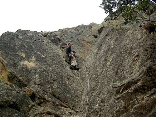 Climbing at Aquarian Valley
Bouldering
There are so many boulders around Skyline that there is too much to write all down here. The best thing to do is to pick up a bouldering guide for Castle Rock. Check out this list for diagrams and routes. V2 on Magoo's V2 on Magoo's |  Ben bouldering Magoo's Ben bouldering Magoo's | |
 Magoo's Magoo's |  Parking Lot Rock Parking Lot Rock | |
Links
Castle Rock State ParkSanborn County Park
Bay Area Rock Climbers. This site provides very helpful slidehows of all crags. I got most of my beta from this site.
Here is a .pdf map showing all rocks in Castle Rock.