
-
 9123 Hits
-
 72.87% Score
-
 3 Votes
|
|
Route |
|---|---|
|
|
48.15050°N / 120.8132°W |
|
|
Basic snow/talus/scree |
|
|
Half a day |
|
|
Walk-up |
|
|
Approach
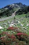
Starting at the Phelps Creek trailhead hike 3.2 miles to Leroy Creek and cross the creek. On the north side of the creek the abandoned Leroy Creek trail is easily found. It climbs eastwardly beside the creek and at about two miles enters the upper Leroy Creek basin directly under Seven Fingered Jack and the east slopes of Mt. Maude.
 |  |  |  |  |
Route Description
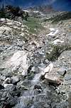
Starting in the meadowy upper Leroy Creek basin at about 6,000', ascend the prominent gully NE toward the Maude-7FJ col. At the large bench (6,800') turn north toward the obvious snow couloir. Either ascend this couloir, or if preferred, just before entering the narrow portion of the couloir there is an easy ramp to the left toward the SW ridge. The couloir leads to a higher point on the ridge. Ascend the ridge toward the leftmost point visible from the basin below. The summit is left of all the visible "fingers".
 |  |  |  |  |
Essential Gear
An ice axe is mandatory if snow is present, or if you ascend the couloir. I recommend a helmet as well.
Miscellaneous Info
If you have information about this route that doesn't pertain to any of the other sections, please add it here.
 |