
-
 15125 Hits
-
 84.81% Score
-
 19 Votes
|
|
Mountain/Rock |
|---|---|
|
|
35.11850°N / 25.49750°E |
|
|
Hiking, Mountaineering, Trad Climbing, Mixed, Scrambling |
|
|
Spring, Summer, Fall, Winter |
|
|
7044 ft / 2147 m |
|
|
Overview
 Spathi seen from the south-west Spathi seen from the south-west |
Of the three mountain ranges on Crete, which exceed 2000m, the Dikti Range / Ορος Δικτη, is the lowest and easternmost one. Its two highest mountains almost share the same elevation, Αφέντης Χριστός / Afentis Christos at 2141m and Spathi / Σπαθη at 2147m. The latter, as highpoint of the range is often called Dikti itself and is easily the most popular and important mountain of the range.
 |  |  |
Spathi (Dikti) / Σπαθη (Δικτη) can be climbed by three easy but long and remote routes, which in addition require a lot elevation to be gained. One, the normal route starts at the Lasithi Palteau, or including the drive along a potholed road at the Limnakarou Plateau. The other two start at the mountain village Selakanu to the south-east of the mountain, at 800m, some 1400m lower than the summit. One climbs Lazaros another 2000er befor traversing the ridge between the two mountains. The other joins the normal route to the south-west of Spathi, in a saddle which separates Spathi from Afentis Christos.
 |  |  |
In addition to the hiking routes, Spathi also is home to a dozen climbing routes, all on its north face. However, as the Dikti limestone is notoriously brittle all routes involve serious objective hazards. The following picture shows these routes:
  |
| # | Route Name | UIAA Grade | Length |
| 1 | Latzoi | III | 80m |
| 2 | Kilomeni Skala | III | 100m |
| 3 | Aleksia | IV | 120m |
| 4 | Mathima Ptosis | IV | 120m |
| 5 | Dathilaki | IV | 125m |
| 6 | Odos Skiraka | IV | 100m |
| 7 | Annoula | V (VI-) | 120m |
| 8 | Kri Kri | V | 190m |
| 9 | Diktamos | IV | 150m |
| 10 | Diktamos variation | IV | 150m |
| 11 | Kopsi Tis Tskoudias | V+ | 150m |
| 12 | Neraida | IV (IV-) | 500m |
| 13 | Topsi Ton Karpenisioton | IV+ (IV-) | 350m |
Like all of Crete, the Dikti Range and with it the highest mountain, Spathi, is made up from brittle limestone. It is particularly evident on the normal route, which traverses large karst areas, before even reaching the saddle between Spathi and Afentis Christos. Also, the almost circular plateaus Lasithi, Limnakarou and Katharo are former karst plains and collapsed dolines. A large part of the normal route follows the path of a former glacier, negotiating the broad ground moraines in its central part.
 | 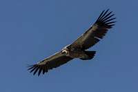 |  |
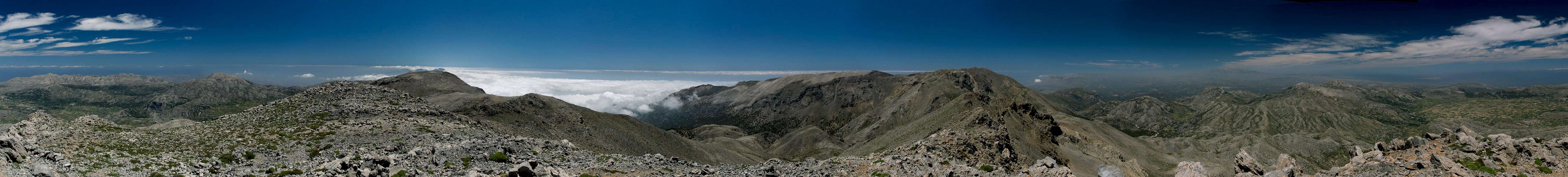
Views from Spathi / Dikti cover the eastern half of Crete, ranging from Psiloritis in the west to Capes Sideros and Plakos in the very east. Griffon Vultures love to float on the thermals above the north face and if you are lucky you can see one of these huge majestic birds up close. They prey for the old, very young or sick livestock of sheep and goats which are left to graze all sides of the mountains. Moving herds can attract up to two dozens of the birds.
Finally the European trekking trail E4 passes close by. In fact both the Limnakarou- and the southern Selakano-Routes follow the course of the trail up to the saddle south-west of Spathi. You will find lots of trekkers on the route in early spring and late autumn. Summer temperatures can be scorchingly hot, even at 2147m.
360° Summit Panorama
 |
Getting There
 The Kataro Plateau and Lazaros seen from Spathi
There are two international airports on Crete, both in the north of the island. One is at Chania in the west, the other is at Heraklion in the centre.
There are myriads of ferries in Greece, which connect the many islands of the country. Consequently there are many ferry harbours and Crete is no exception. However, most of the smaller harbours only cater for transportation to the other islands while the major lines to the mainland are reserved to two harbours, Souda near Chania and Heraklion. Both serve connections to Peiraias and Thessaloniki.
To reach the trailheads you need to follow highway no 90 east from Heraklion.
- For the Lasithi Plateau leave the highway near Chersonisos and follow the signs for the Plateau. Once on the plateau, drive to Agios Georgios and Avrakontes, where a small mountain road heads up to the Limnakarou Plateau.
- For Selakano drive highway 90 to Pachia Ammos, where you turn on the road to Ierapetra. Here turn west again to Mirtos, where you switch to the road to Males (in Mournies you can turn west for the third trailhead at Kato Simi). In Males, follow the dead end road to Christos but before you reach the village the narrow road to Selakano turns off to the right.
Red Tape
 The Spathi / Dikti north face seen from the moraine of the former glacier
There is no red tape but respect the farmers on the Lasithi and Limnakarou plateaus. There also are huge flocks of sheep and goats which often are fenced in. Close gates or wherever you have to climb a fence make sure that it still stands upright afterwards.
Accommodation
 The Agio Pnevma chapel in front of Spathi
You can quite easily find hotel rooms and apartments everywhere on the coasts. All European travel companies offer accommodation so a visit to your nearest travel office will find you some. In the mountain villages there always are inns and if everything fails you can pitch a tent.
There are abundant campgrounds along the coast and on many of the beaches you can pitch your tent. The touristic beaches in the north and the beaches in the vicinity of tourist towns are mostly off-limits but there is many a cove which you can use. In the mountains you will often find cattle (goat and sheep) fences which you should respect. There is many a green meadow in one of the plains but you should be aware that you’ll be woken up by goats. Again, in the vicinity of villages, rather ask the locals if you can use their land.
West of Spathi, on the aforementioned karst plateau you can find the Stanestasi Hut. It is a self service hut which offers room for limited accommodation. It is mainly used by the E4 trekkers.
Weather Conditions
Maps & Books
There are quite a number of maps and books out there, which deal with the island of Crete and naturally I don’t know them all. This is the list of maps and books which I used and I appreciate it very much if you can add to itMaps
Unfortunately there are no decent topographic maps of Crete. The best maps I could find are scaled 1:100000 and contain the main hiking routes on the island. In one case the map showed wrong paths and roads (exchanged them) but in general they were quite useful. In any case they were better than the Anvasi Maps, also scaled 1:100000, which claim to be topographic maps but miss routes and even mountains
- Kreta / Crete / ΚΡΗΤΗ Western Part
Touring Map
1:100000
Harms Verlag
ISBN: 3-927468-16-9
- Kreta / Crete / ΚΡΗΤΗ Eastern Part
Touring Map
1:100000
Harms Verlag
ISBN: 3-927468-17-7
Books
Since there are no good topographical maps of Crete you should take care to get a good guidebook. The ones I used have good tour suggestions though the descriptions often are somewhat shortish and can be misleading. The books are available in German and English.
- Kreta Ost / Crete East
Gert Hirner / Jakob Murböck (translation: Gill Round)
Rother Verlag
ISBN:
978-3-7633-4004-0 (German)
978-3-7633-4822-0 (English)