
-
 3189 Hits
-
 74.01% Score
-
 4 Votes
|
|
Route |
|---|---|
|
|
46.65456°N / 13.41092°E |
|
|
Hiking |
|
|
Spring, Summer, Fall |
|
|
Most of a day |
|
|
Medium hard hike |
|
|
Rating the Route (By Hiking Standards)

Spitzegel from Fischer Alm

On the S slopes of Kriebhoehe
0. General: From 996 m to 2119 m, exposition N, E and S. At first a steep hike-up through woods, then an even more steep crossing of the southern slopes of the main ridge, then summiting by the ridge. Gear: Good hiking shoes and poles. The upper part is very panoramic.
1. Effort: cca 1200 m, 3 h 30 min.
2. Power: 2 - Easy (mostly 1 - no difficulties, on some places a few pull-ups).
3. Psyche: 3 - Moderate. The southern slopes are exposed.
4. Orientation: 2 - Easy (all the time marked).
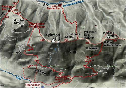
Getting There
See the main page of Spitzegel, how to get into the valley of Tscherniheimer Bach! The parking place is in Weissenbach, the road further up the valley is closed for public traffic.Route Description
From the parking place we continue by the road. Till Fischer Alm we have some good 15 minutes of walk. On the meadow before the hut an arrow with inscription directs us left, so towards the south. The path looks like a cart road, but already after some 50 meters the marks deter left. A good, narrow path crosses the dry creek bed and then goes through the woods, allways towards the left. That will be the characteristic also later: whenever the path does not go in turns upwards, it crosses the slopes towards the left. Soon the path exits the wood and goes up by the area, where the forrest is completely cut down. So, the path is harder to be traced, but marks on distant trees help us to orient. Above the clearing the path continues through the woods, soon hits the mountain road and crosses it, continuing allways towards the south. On the altitude of some 1500 m we reach a ridge in the forrest, where shortly the view towards the NW opens. The path turns left again, ascending the ridge and crossing the slopes. The view towards Latschur |  The view on Vellacher Egel |
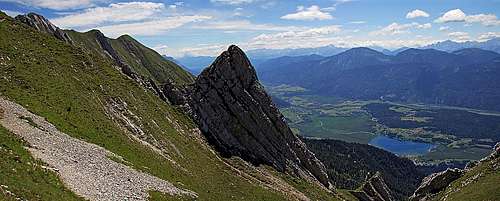
On the altitude of some less than 1700 m the path gains a distinct northern side ridge. There it turns sharply right, following the ridge upwards. Nice, light larch woods allow us a few nice views around, on the ridge we also see hunters posts. The place is called Standlriegel. Yet above pine bushes start prevailing, the views around are broader. The path keeps left of the ridge, on the eastern side and in front of us we clearly see the rocky wall of Vellacher Egel and the broad, grassy saddle right of it. The path aims towards it. There is the main ridge of Spitzegel massif, from the saddle a fantastic view opens towards the south and down on Presseger See.
 Vellacher Egel |  Gailtal and Presseger See |  Crossing the S slopes |
Now we turn right, towards the west. The path however does not follow the main ridge (crossing the nearby Kriebhoehe would be more difficult), but jumps down into the southern slopes and starts crossing them. There is the most picturesque and attractive part of the route. After a short descent the path soon starts crossing horizontally, aiming right of a distinct, sharp needle, peeking out of the slopes.
Crossing the southern slopes of Kriebhoehe
After passing the needle, the path ascends again, there we must overcome a few rocks. A bit exposed passage is not protected. Then the path continues crossing, soon it goes over another short section of rocks, where some easy scrambling is needed again. In the continuation we gain the main ridge west of Kriebhoehe and continue by it towards the west. It looks that we are already on the main summit, but ascending the grassy and rocky bump ahead of us we realise that the main summit is behind it. So, agaih slightly down and then up again. The path goes on the northern side, then on the rocky summit ridge and through all kinds of colourful flowers we reach the summit cross.
 Crossing the slopes |  Kriebhoehe and Vellacher Egel |  Spitzegel summit from the E |
We can quickest descend by the same route, but more beautiful is the route over Radnig Alm and Bodenalm, offering us a nice round tour.