

-
 31268 Hits
-
 88.19% Score
-
 26 Votes
|
|
Mountain/Rock |
|---|---|
|
|
51.16987°N / 116.0533°W |
|
|
Mountaineering, Ice Climbing, Scrambling |
|
|
10351 ft / 3155 m |
|
|
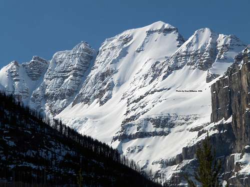 Stanley Peak, Kootenay National Park, from the north May, 2006.Face routes from left to right, Y Couloir, Waterman Couloir and Kahl Route.Photo by Dow Williams
 Stanley Peak from the north (Mount Whymper)
Overview
 Approach to glacier.
Stanley Peak is located about 6.5 Km south of Vermilion Pass in the Ball Range of Kootenay National Park, British Columbia. From a climbing standpoint, the outstanding feature of the peak is the snow and ice of its impressive north face. There are two exceptionally fine routes on this face that are of a relatively moderate standard and easily accessible placing them among the most popular snow and ice routes in the Canadian Rockies.Edward Whymper of Matterhorn fame first climbed the mountain via the Northwest Ridge in 1901, with guides: J. Bossoney, C. Kaufmann, C. Klucker, J. Pollinger. Whymper named the peak for Frederick Arthur Stanley who was the man responsible for the Stanley Cup (also Canada's sixth Governor General).
Getting There
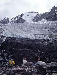 Toe of glacier
Kootenay National Park is about 900 km east of Vancouver and 170 km west of Calgary. Kootenay National Park Access InformationVermilion Pass is on Highway 93 South (AKA Kootenay Parkway) between Castle Junction and Radium Hot Springs within the Park.Access to the north side routes on the peak is via the Stanley Glacier Trail that starts about 3 Km west of Vermilion Pass.The scrambling route on the south side of the peak is accessed via Haffner Creek that is crossed by the highway about 10 Km west of the pass.Kootenay National Park Map
Red Tape
Kootenay National Park has a Voluntary Safety Registration program.A Wilderness Pass is required for back country camping within the Park.
Routes Overview
 Kahl Route
All of the north side routes are accessed via the Stanley Glacier Trail (about 5 Km to the glacier). The climbs can be done in a long day from the car, or more leisurely with a camp at the head of the valley below the glacier. (About 7 Km and 1600 m of vertical gain from the trailhead.)Northwest Ridge The first ascent route and the common descent route. From the end of the Stanley Glacier Trail one works their way up through cliff bands to the ridge which is followed to the summit. It is very straight forward except for one cliff band on the ridge which many parties rappel in descent.North Face - Kahl Route (AKA North Face West End). Grade III. Probably the most popular route on the peak, it ascends the highest part of the face directly to the summit. Attain the glacier from the end of the trail and cross to below the highest part of the face leading directly to the summit. Climb essentially straight up bearing left of the rock outcrops.First Ascent: N. Ellena & H. Kahl, July 1966.North Face - Waterman Couloir Obvious first large couloir to the east of the Kahl Route.North Face - Y Couloir (AKA Couloir on the NE Face). Grade III - about 10 pitches up to 55 degrees. The right branch of the Y is followed to the top. Many parties do not proceed to the summit, but descend via the NE Ridge.First Ascent: M. Toft & G. Spohr, August 1975North Face - East End Climbs snow, ice, and possibly rock to the top of the NE ridge which is followed to the summit.First Ascent: G. Boles & R. Geber, 1970Northeast East Ridge Ascends the NE Ridge of secondary peak (3035 m), then descends to the saddle with the main peak and up the ridge to the summit.South Side Scramble. The approach is up Haffner Creek, then up ledges and steep rock bands to the top. The bush whack up Haffner Creek is reported to be very unpleasant and the finding the correct route to the summit difficult.
Camping & Accommodations
Mountain Conditions
Current WeatherPark Warden Contact Info
External Links
Peakfinder Stanley Peak PageRoute descriptions of the north face routes are taken directly from the referenced guide.