
-
 6914 Hits
-
 84.27% Score
-
 18 Votes
|
|
Route |
|---|---|
|
|
47.54525°N / 11.02272°E |
|
|
Hiking |
|
|
Spring, Summer, Fall |
|
|
A long day |
|
|
Long hike with some rock scramble |
|
|
Overview
“Director´s Cut” is my name for this Seven Summit route, which is a quite strenuous, long and demanding hike in one of the most remote parts of Ammergauer Alps, the Notkarspitze – subgroup. This subrange is located in the eastern part of Ammergau Alps and consists of 10 different summits:Director´s Cut route traverses seven of these summits, beginning with Großer Zunterkopf and ending at Kieneckspitze. Some people do the traverse Großer Zunterkopf – Windstierlkopf from and to Graswang, other summit Kieneck via Geißsprüngkopf. I rarely have met anybody who did the whole loop from Großer Zunderkopf to Kieneckspitze so I felt about that route that it is like a director´s cut.
Director´s cut starts and ends at the same trailhead. It shall be a long and huge traverse with no forth and back deviations. Unfortunately there is no direct trail from Graswang to Notkarspitze thus Notkarspitze has to be excluded from this grand traverse. Brünstelkopf can be included (see “Alternative Route” below) but then you have not the Seven Summits …..
I love this traverse in early summer when there still is some snow on the ridges and it is already summer in the valleys. You will have the whole range of wildflowers and blossoms from summer until early springtime beneath the trail.
The whole traverse is a strenuous day, about 8 hours to go and between 1700 and 1800 meters of altitude difference to overcome. And you will not meet many people, even during sunny weekends.
  |
Getting There
 Graswang with trailhead
Use highway A 95 from Munich to its end and follow the road B 2 to Oberau.
At Oberau take B 23 to Ettal.
After Ettal follow road St 2060 direction Graswang / Linderhof until you reach the eastern part of the little village of Graswang. There is a little chapel on the right. On the left there is a small parking area in front of the bridge over the creek Linder.
This is the trailhead. Leave your car there.
Another parking area (fee required) is signposted in the village behind the inn “Fischerwirt”. You have to walk back about 15 minutes to reach the trailhead for this route.
Route Description
 Director´s cut route overview
Ascent to Kuhalm Diensthütte
The „Director´s Cut” - route starts and ends at the Graswang trailhead.
Traverse the bridge over the Linder creek and proceed on the forest road to the forester´s lodge “Dickelschwaig”. At the edge of the forest south of the forester´s lodge take the right forest road, signposted “Notkarspitze” and “Kienjoch” (the left one leads to Ettal). Go straight on, don´t use the signposted trail, branching off to the right.
After a while you traverse the Kühalpenbach creek. Immediately after the bridge take again the right road leading into Kühalpental (signposted “Wasserfall” and “Kienjoch”). After 10 minutes a trail branches off to the right (signposts for Kienjoch / Notkarspitze). Follow this trail on two footbridges over Kühalpenbach. The trail steadily ascends on the western side of the Kühalpental high above the valley ground thus avoiding a steep narrow and rocky canyon. You have great views of this canyon from the trail. During early summer there are many orchids blossoming on the canyons slopes.
 Kühalpenbach canyon
South of the canyon the trail reaches the valley bottom again. It now follows the creek left and right of it, traversing it several times. High up Kühalpenbach valley it leaves it to the left and zigzags up to Kuhalm Diensthütte, a forest lodge at the forest road coming up from Graswang.
Ascent to Großer Zunderkopf
Follow the forest road up two switchbacks. At the second one a trail branches off to the right. It ascends to the col between Windstierlkopf and Geißsprüngkopf and can be used as a bail out possibility from there.
For the route follow the forest road to the left until a trail leaves to the left and, after 100 m, another one branches off to the right (signposts “Notkarspitze”). This trail traverses the northern slopes of Großer Zunderkopf through light woods and meadows, traverses an erosion chute, climbs a shoulder on a subridge with a ruined Alm hut and reaches a col on a northern subridge of Großer Zunderkopf. The trail to Notkarspitze descends here into the northern cirque below Brünstelkopf.
Leave the trail at this col and start to traverse level and off-trail into the cirque. Pay attention: this is a steep traverse ! Follow small pathes made by Gemsen.
Aim at some peculiar spruces amidst the dwarf pines and pass directly below them. Immediately after those spruces ascend the steep slope directly using the meadow passages between the dwarf pines aiming at the foot of a peculiar rock formation above the before mentioned spruces. This is a steep off-trail ascend.
The old trail which formely led up this slope is visible amidst the spruces and continues behind them clearly visible. But don´t follow it, it ends soon after the spruces amidst thick dwarf pines – no fun.
 Großer Zunderkopf and Vorderer Felderkopf
While ascending you traverse the above mentioned, heavily overgrown old trail which formerly zigzagged up the slope and nowadays cannot be used in its lower parts.
At the foot of the before mentioned rock formation, however, this trail is still visible and can now be used for the upper parts of this ascent. Follow the trail, it zigzags up and traverses to the col between Brünstelkopf and Großer Zunderkopf.
At the col there is a trail junction with the trail coming up from Pflegersee via Brünstelkopf. Follow the trail to the right, it ascends the east ridge of Großer Zunterkopf through dense dwarf pines on the north and on the south side up to the summit.
Look out: the summit zone is adorned with blue Gentiana blossoms in early summer. In spring and early summer there often is still snow on the northern parts of the summit ridge. Normally there is a good foot track and you will not miss the right direction.
Alternative Route
Instead of the off-trail ascent follow the Notkarspitze trail, traversing the cirque below Brünstelkopf. The trail reaches a broad col between Notkarspitze and Brünstelkopf. Turn right there and summit Brünstelkopf. Follow the ridge crest down to the col between Brünstelkopf and Großer Zunderkopf where you meet the above mentioned route. This variation is about ¾ hours longer !
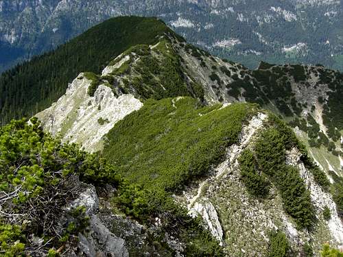
 Traverse Großer Zunderkopf - Vorderer Felderkopf
Traverse Großer Zunderkopf – Vorderer Felderkopf – Felderkopf - Windstierlkopf
From Großer Zunderkopf the trail descends on the west side of the summit to the col and the meadows east of Vorderer Felderkopf. The ascent to Vorderer Felderkopf is on its east ridge on a good trail, in spring and early summer partly on snow.
At Vorderer Felderkopf take a first well deserved long break and maybe a short nap in the lush meadows.
 Großer Zunderkopf, Vorderer Felderkopf and Felderkopf
 Continue descending on the south side of the west ridge through blossom adorned meadows and dwarf pines down to the huge meadow of Felderkopf, where the trail disappears. Traverse Felderkopf meadows near the summit and directly below the dwarf pines which are growing on the summit ridge, the direct and level traverse will end in a swamp meadow which is not advisable at all. From Felderkopf descend to the col in front of Windstierlkopf. At the col the trail reappears and descends slightly, winding through dwarf pines. After a while at a cattle fence a narrow trail branches off to the right. Take this trail, it ascends steeply to the summit of Windstierlkopf. Near the summit, which can be reached from the trail in 2 Minutes, the trail changes on the northwestside of Windstierlkopf and descends with some switchbacks to a notch below Windstierlkopf. There again can be some snow in spring / early summer.

From the notch the trail traverses level the connecting ridge between Windstierlkopf and Geißsprüngkopf on its north side until it reaches a trail junction with the trail coming directly up from Kuhalm Diensthütte. If you are exhausted, tired or if the weather is instable and doubtful better bail out here and return to Graswang via Kuhalm-Diensthütte.
 Windstierlkopf and the traverse to Geißsprüngkopf
 Ascent to Geißsprüngkopf
Traverse of Geißsprüngkopf to Kienjoch
If you want to go on follow the trail to the left. It immediately ascends to the col between Windstierlkopf and Geißsprüngkopf and climbs steeply up the east ridge of Geißsprüngkopf. There are some rocks to overcome after the summit, where the trail descends into the col between Geißsprüngkopf and Kienjoch.
After this col Kienjoch is quickly reached. Take another long break at this highest point of the Director´s Cut – route. You have great views over the whole Ammergau Alps and the Wetterstein mountains. In the southwest the Lechtal Alps and the Ötztal mountains are visible.
 Traverse Geißsprüngkopf - Kienjoch - Kieneckspitze
Traverse to Kieneckspitze and descent
From Kienjoch you have to follow now the north arête to Kieneckspitze. Now the route becomes a little bit more difficult because beginning at Kienjoch the main ridge of the subgroup is more rugged, narrow and rocky.
A narrow and mainly unmarked trail starts at Kienjoch following the arête to the north. There is a steep descend with some rock scramble down to a notch north of Kienjoch. From the notch the trail continues on the arête or shortly east or west of it with some ups and downs and some more rock scramble until it reaches the not very prominent summit of Kieneckspitze. There is a huge cairn at the highest point of the long summit ridge.
 Traverse Kienjoch - Kieneckspitze
From Kieneckspitze the trail follows the arête mostly on its east or west side, thus gaining another notch below Kieneckspitze. The arête then ascends slightly again to an unnamed secondary summit in the subgroups main ridge. There the trail zigzags down steeply into Schattenwald Kar a steep cirque at the northern end of the western part of the main ridge.
Soon the trail keeps on the eastern side of the cirque and leaves it to gain a little meadow with a tiny lake at the upper end of a subridge dropping down to Graswang.
 Upper part of north/northeast ridge trail of Kieneckspitze
This tiny lake is full of tadpoles and frogs in late spring / early summer so take a little break and watch them enjoying their alpine summer feast.
The trail follows closely the steep subridge and leaves it at about 1200 m hight to the left. Thus Schattenwald, a forest above Graswang, is reached. The trail zigzags down through the woods and some clearings until it reaches the forest road Graswang – Kuhalm Diensthütte. To return to Graswang you can use this forest road.
Another possibility is the continuing trail, entering the dense woods across the forest road. After another 150 m of altitude difference it reaches the forest road between Dickelschwaig and the Kühalmbach creek. Turn left on the forest road and follow the road, passing Dickelschwaig to the trailhead.
 Lower part of northeast ridge trail of Kieneckspitze
There is a bench at the edge of the wood in front of the Dickelschwaig meadows. This always is a good place on sunny evenings to take a rest and contemplate about the Director´s Cut route and the experiences of the day and to savour the peaceful evening atmosphere before ending the day at the Fischerwirt inn at Graswang with a beer and a decent meal.
Essential Gear
 Silene dioica Silene dioica |  Anemone silvestris Anemone silvestris |  Cypripedium calciolus Cypripedium calciolus |
You need normal hiking gear and good hiking shoes.
Take enough to drink with you, most of the time you will be on ridges and aretes without water resupply possibilities.
Director´s cut route is grat in late spring and early summer, when you can see all the wildflowers of the Northern Limestone Alps and some rare orchids.
In autumn you will have clear, fine and still warm but shorter days, so don´t forget some headlamps.
 Dacylorhiza maculata Dacylorhiza maculata |  Aquilegia vulgaris Aquilegia vulgaris |  Centaurea montana Centaurea montana |