Introduction
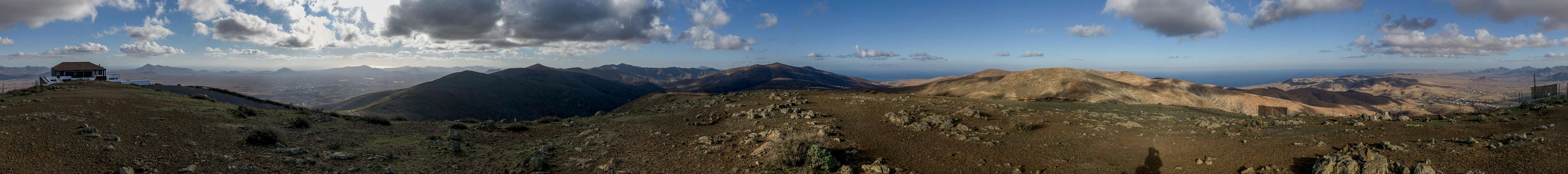
![Clouds above the Tetir Range]() The Tetir Range above Casillas del Angel
The Tetir Range above Casillas del Angel
Among the
Canary Islands Fuerteventura is easily my least favourite one. Its mountains are low – most of the island is flat as a pancake and tourism is rampant. Over the years all the nice bays have been developed with “urbanization” – in this case holiday homes and hotels for the tourist crowd. Quite a number of them had to be abandoned as the crowds preferred the full service areas in the north near
Corralejo or the south near
Morro Jable. The downside of this is there are no “original” villages anymore, the upside that you can get a good flat in a huge complex – which is very queit due to the low usage.
Nature preserves have been set aside in several parts of the islands but when it comes to tourists they are easily overruled. The large desert
El Jable on
Isthmo de la Pared, though protected, has seen the construction of a four laned motorway through its southern part. Some of the most unique hikes of the island thus have been cut off from their trailheads.
Also,
Fuerteventura is a very dry island. In case of rain quickly a green layer develops with lots of little flowers. But the regular colour is any shade of brown. During our first visit we were lucky enough to arrive after and stay during a rainy period, this time around things were different. Nevertheless there is some rather rough charm about
Fuerteventura. You can venture almost anywhere and the lack of a developed network of hiking trails forces you to explore on your own. And when you do you are almost sure to encounter something you wouldn’t have expected.
Dec 25th 2017 – Travel Day (and more)
![Giniginamar Bay]() Giniginamar Bay seen from Punta del Morrete
Giniginamar Bay seen from Punta del Morrete
We’ve made a habit of celebrating Christmas Eve with our respective families which was rather trying for me this year. My mother – on her 87th birthday in November had fallen on her hip which had made an artificial femur head necessary. She was in rehab and it was a rather depressing experience to visit her and hand her the presents. Later we celebrated with Judith’s family but had to leave early as the alarm would be ringing at 3:20 a.m.. An alpine start to the
Fuerteventura vacation.
Luckily everything went perfectly. The taxi was in time, check in and baggage check queues were short, the plane started on time and was half an hour early at
Puerto del Rosario. No issues with the rental car lady and soon we were in front of our apartment in
Giniginamar (urbanization), waiting for the caretaker to hand us the keys. He arrived ten minutes later and by lunchtime we had unpacked our suitcases and were wondering how to spend the rest of the day.
Our guidebook suggested a difficult hike along the south coast from
Giniginamar to the next village,
Tarajalejo and we decided to attempt it as far as our tired bodies would get us. We didn’t expect to do the full trip, which was calculated to last 5 ½ h. So we headed down to the pebble beach, looking for the narrow path which should take us to the first cliff. We found it only because some people were walking down there dogs from the cliff but once there on
Punta del Morrete the further route was obvious.
The south coasts of any of the
Islas Canarias are dry but here a veritable stone desert awaited us. Only very occasionally a very lean bush would shed some green on the slopes but the general aspect was brown and dry. Still, we had wonderful weather and the blue of sky and
Atlantic Ocean made good for all the brown landscape. We had to cross three deep barrancos but finally found ourselves on a hill overlooking the destination village,
Tarajalejo. The urbanization with its green sports field looked like a mirage. We decided not to hike down but instead return to our apartment the way we came.
Dec 26th 2017 – A Ridge Traverse in the Betancuria Range
![Betancuria]() Looking across Betancuria with Gran Montaña and Pico de Betancuria behind
Looking across Betancuria with Gran Montaña and Pico de Betancuria behind was Fuerteventura’s first capital. Founded by conquistador
Jean de Bethencourt inside these mountains for fear of pirates it is a picture book village today. Its mountains would qualify as hills everywhere else but here they look grander than they are. And if you come from
Pajara in the south you’d be excused if you believed it:
Risco Blanco and
Barranco de las Peñitas definitely look like they belong into a greater range. But more on this later.
This morning we had decided to start in
Betancuria, hike to
Morro Velosa in the north and then follow the long eastern ridge of the range all the way to
Gran Montaña in the south, return halfway and descend to
Betancura from
Degollada de la Villa. And to underline what was said before – the big mountain,
Gran Montaña, is a whooping 708m high…
360° Summit Panorama from Morro Velosa |
Though there were signs everywhere demanding parking fees for the few spaces there was nobody there to cash in as we started from the biggest of the lots. We wound our way along a path through the village, passing the church (a former bishop’s seat of a bishop who never arrived) and a multitude of souvenir shops. Heading north we quickly reached the ruins of a monastery, the
Convento de San Buenaventura where we left the village roads and heade onto a path through a steep and narrow valley. It levelled out on the saddle
Degollada de Maniumbre from where a short scramble took us to the summit restaurant and summit of
Morro Velosa. Like so many of the tourist attractions on
Fuerteventura the restaurant was closed. Here, on our first summit, we realized the fierceness of the winds but what else do you expect on an island with this particular name?
Returning to
Degollada de Maniumbre we started the traverse with a hike to
Montaña Tegu, then
Morro del Cortijo,
Degollada de la Villa (we saw two hikers there) and
Morro Janana. The latter has a forest of radio installations on its top but is also home to an experiment to reestablish the
Canary Pine on the island. Its slopes are covered by that hardy tree, most of them little taller than bush-sized. All the way we had
Betancuria and its mountains on our right and a far reaching view across the plains of
Antigua and
Tuineje on our left.
![Betancuria Range]() The Betancuria Range from Morro Jurado
The Betancuria Range from Morro Jurado
From this fourth summit we descended across
Morro de Tabagoste to
Degollada Vista del Pueblo and on to
Degollada Pechillera. Here the final ascent to the last two summits,
Morro Jurado and finally
Gran Montaña. Winds were raging up there and we had to look for shelter. Having been up on
Gran Montaña before, we knew a stone ring shelter a few steps south of the summit, so we retreated there to have lunch. But for the wind everything was perfect with far reaching views all across the island.
![Canarian Kestrel (Falco tinnunculus canariensis)]() Canary Kestrel lady (Falco tinnunculus canariensis)
Canary Kestrel lady (Falco tinnunculus canariensis)
The return trip took us across three more summits until we returned to
Degollada de la Villa. Again we met hikers there while the remainder of the trip across 10 summits had been absolutely lonesome. Anyway, we returned to civilization hiking down a broad dirt road to
Betancuria, where a sleepy cat and an alert
Canary Kestrel greeted us. All in all we hiked more than 1000m of elevation and almost 20km distance.
Dec 27th 2017 – A Visit to the Beach
![Sticking its head out of Playa de Barlovento]() A Gnu (?) sticking its head out of Playa de Barlovento
A Gnu (?) sticking its head out of Playa de Barlovento
It turned out to be a rather frustrating day – or maybe it only started as one. Driving south from
Giniginamar to the narrowest part of the island,
Isthmo de la Pared, we realized (as already mentioned in the introduction) that a new motorway had been built around
Costa Calma through the nature preserve of
El Jable.
El Jable is a sand dune desert with only little vegetation and has always been under attach from tourists, who drive through it in their 4x4s or ATVs. But now a large chunk had been cut off.
Moreover, at our intended trailhead, construction for the remaining part of the motorway was ongoing so that we had to pass bulldozers and even heavier equipment on our way through
Baranco de Pecenecal. The formerly narrow dirt road had been widened recently and it looked like one of these very frustrating days.
However, we went on and the farther we got inside the barranco the less we heard and saw from the construction work. Beside the valley two “mountains” of more than 600m rise, not much but you are prepared for less on
Fuerteventura. Finally we reached
Degollada de Pecenescal, a saddle at 250m, where the terrain suddenly turns into an almost cliff-like drop to the beaches on
Fuerteventura’s west coast.
![Sand dunes on El Jable]() Sand dunes on El Jable
Sand dunes on El Jable
There is a hiking trail down to
Playa de Barlovento and that’s where we went. It runs through (or across) rubble-like erosion structures which in other parts turn into sandstone like formations. The beach itself is unsuitable for swimming or bathing with huge breakers rolling down on it from the west. Thus the 12km of white sand beaches,
Playa de Barlovento and
Playa de Cofete are among the most beautiful beaches on the planet.
![Isthmo de la Pared with El Jable]() El Jablle seen from Morro del Rinconcillo
El Jablle seen from Morro del Rinconcillo
We got down there at almost high tide and intended to hike north, attempting to scramble back up towards
El Jable at the northern end of
Playa de Barlovento. The beach gets very narrow in places and we had to hurry, not to be overtaken by the tide. Finally we reached the point wher the GPS-maps claimed a path would lead and after some 10 minutes of searching we actually found it. The path led through the rubble-like face towards
El Jable, where another half hour took us to a fine lookout spot. High winds, however forced us to take shelter again, mainly because of all the flying sand in the air.
After lunch we climbed up to
Morro del Rinconcillo and on to
Lomo del Cuchillete, where we found a giant stone compass on the summit. We returned across the east slopes to the regular hiking route, which soon turned into the dirt road which would take us back to our car among the motorway construction.
Dec 28th 2017 – Vallebron in the North-East
![Cerro de Aceitunal (688m), Morro de Agua Salada (509m), Montaña Martinez (497m), Pico de la Fortaleza (595m)]() Cerro de Aceitunal, Morro de Agua Salada, Montaña Martinez, Pico de la Fortaleza
Cerro de Aceitunal, Morro de Agua Salada, Montaña Martinez, Pico de la Fortaleza
During our last visit we had climbed
Montaña de Escanfraga near
Villaverde in the north-east and the region to the south, near
Vallebron had looked very promising. Moreover the maps claimed it was “protected landscape” so that we were hoping for something interesting. A gps-track I had found at wikiloc.com showed a loop from
Vallebron to
Tindaya to
La Matilla and back, which we intended to follow.
We started at
La Matilla and headed up to
Montaña de la Muda’s east ridge. The summit itself is off limits due to a military radio installation but we reached the ridge, intending to follow it for some 4 km to the east. We climbed some minor summits, skipped others but when it came to descending any indication of a path vanished. Thus we had to freestyle down a very steep and chossy slope in order to get to the village of
Vallebron and the protected landscape. The latter couldn’t keep up to the promise, a dry village, lots of abandoned pastures but nothing that would explain the protection status.
Vallebron would lie in a large valley if it weren’t for the knife-edge east ridge of
Montaña Enmedia, which splits the valley in two:
Valle Grande to the south and
Vallle Chico in the north. We hiked through
Valle Chico which gradually rises until it reaches a saddle at some 350m elevation where you can look out across the
Tindaya Plain.
![Montaña Quemada (366m), Lomo del Viento (571m), Montaña de la Muda (689m)]() Montaña Quemada, Lomo del Viento, Montaña de la Muda
Montaña Quemada, Lomo del Viento, Montaña de la Muda
We descended to the plain, crossed a highway and then ran into an beach buggy caravan, which sped along our hiking trail. Make that two caravans as the second one passed us 10 minutes later. It must be rather enjoyable to drive with these vehicles and eat the dust of the car in front… Well, anyway we soon made it to
Tindaya Village, which we crossed hiking south towards
Montaña Quemada, an old volcano cone. I nearly sprained my ankle at its base, but reacted fast enough. I limped a few metres but was fit enough for the further descent into
Barranco del Risco. From here we hiked back to our car in
La Matilla, always staying beneath the rather impressive west face of
Cerro de Aceitunal, which we marked for a future outing.
Dec 29th 2017 – sea cliffs between Punta Pesebre and Punta di Barlovento
![Looking along Jandia s north coast from Punta Pesebre]() Looking along Jandia's north coast
Looking along Jandia's north coast
A long drive took us to the westernmost point of
Fuerteventura,
Punta Pesebre. It required a drive of 30km of dirt road – very trying for the car and tiring for the driver. Yet we arrived at the cape at a little after 9 a.m. and immediately started hiking the north coast of the
Jandia Peninsula. The low coast quickly turns into steep cliffs, which are draped around wild coves with huge breakers rolling right against them. Not a mountaineering experience but still rather fun.
The area is mostly composed of volcanic choss, very brittle and not at all easy to hike. Every year parts of the hiking trail a devoured by the sea so that they have to change constantly. The remainder of the route is made up from sand and sandstone. Equally brittle but forming interesting erosion caves and half-pipe like formations.
We hiked all the way to
Punta de Barlovento, another cape but there all trails ended. We could have scrambled up
Montaña Aguda and attempt to get to
Playa de Cofete but didn’t really feel like it. Thus we turned around and hiked all the way back. In spite of the long drives this was probably the shortest outing during the two weeks we spent on
Fuerteventura.
Dec 30th 2017 – Volcanic Craters in the North
![Looking across the Lajares plain]() Looking across the Lajares Plain
Looking across the Lajares Plain
The north of
Fuerteventura is probably the flattest part of the island. It is the area which was added last, about 50.000 years ago when several volcanoes erupted, rose out of the sea and covered the whole area with lava. Today the area is a jigsaw puzzle of malpais, lava fields, the biggest of them created by the eruption of
Volcan Bayuyo. Between the village of
Lajares and the town of
Corralejo a geo-trail has been established where you can encounter the most recent history of the island.
![Calderon Hondo]() Calderon Hondo
Calderon Hondo
We had been there before and had hiked the regular geo-trail, which, however, runs along a dirt road. Traffic on the road had annoyed us so that we decided to forgo it and climb all the volcanoes instead. None of which are yery high, all less than 300m but as it turned out many of them have large and impressive craters. And scrambling up volcanic cinder can be rather exhausting as we were soon to find out.
![Malpais de Bayuyo]() The Malpais de Bayuyo
The Malpais de Bayuyo
Starting in
Lajares we first headed along the geo-trail to
Montaña Colorada. However, we left it after less than a kilometer to head for the west ridge of the volcano. And here we encountered a steep ascent to the summit. There was not yet much to see as morning fogs were rolling across the pancake-plains.
Montaña Colorada is connected to its neighbour,
Calderon Hondo and a short descent but steep ascent took us to the summit of the latter.
Calderon Hondo – the name implies it – is a large volcanic crater, almost circular, in which we now looked. Hiking the southern rim we headed for the lookout platform at the eastern end from where we descended to the malpais.
![Caldera de Encantada]() Caldera Encantada
Caldera Encantada
There is a paved trail (geo-trail again) through the malpais and we ended up at the base of
Caldera de Rebanada. This, another ¾ crater was quickly climbed with developing views across the volcanic world around. A short descent and we climbed to the top of the next crater,
Caldera Encantada. Even more volcanic looking, this crater is open at its eastern side. We hiked the north rim gradually descending to where the most obvious ascent to the next crater,
Las Calderas could be started.
![Lanzarote and Los Lobos]() The islands Lanzarote and Los Lobos above Corralejo
The islands Lanzarote and Los Lobos above Corralejo
This was – by far – the worst ascent of the day. Running along rough gravel we had to scramble up a slope of roughly 45°. Finally after some 15 minutes we stood on the top, only to start hiking the north rim again and descending all the way down to the saddle at its eastern base. This saddle separates
Las Calderas from the highest and most important of the volcanoes,
Volcan Bayuyo, which we hiked up via the south ridge.
On top we had lunch and Judith suggested descending the north ridge and later return via the lower
Morros de Bayuyo, several hills to the south-east of the volcanoes. This is exactly what we did with some minor freestyle scrambling in between. In the end it took us back to the base of
Caldera Rebanada and the paved trail across the malpais. During a last break we took at the base of
Calderon Hondo we got visited by barbary ground squirrels, which hoped to grab a hold of our apple cores. Which – I am ashamed to say – they actually got, cute beggars that they are.
New Year’s Eve 2017 – Gran Valle and Playa de Cofete
![Gran Valle]() Looking into Gran Valle from Degollada de Cofete
Looking into Gran Valle from Degollada de Cofete
New Year’s Eve and we went back to the
Jandia Peninsula in the south of
Fuerteventura. It’s the area with the highest mountains and there is a nice hiking route from south to north through
Gran Valle to its end at
Degollada de Cofete. Starting early at the mouth of
Gran Valle near the tourist hotspot
Morro Jable, we hiked the dry and barren valley, gradually gaining elevation. At its end the hike turned into steep switchbacks but after only an hour we had reached the saddle. Here you have a wonderful view on the northern part of the
Jandia Peninsula with its long beaches,
Playa de Barlovento and
Playa de Cofete.
We started to descend and soon reached the last outpost of civilization on
Fuerteventura, the hamlet
Cofete. By now a second hour had passed by, it was 10:30 and the first tourist cars started rolling through the hamlet. They were bound for the parking lot at
Playa de Cofete, right next to the former cemetary of the little hamlet. Tourists go there to marvel at the wonderful beach but since the swell is too dangerous most turn around after half an hour and return to where they came from.
We hiked west to the end of
Playa de Cofete, a 4km hike in one direction. After 200m we were utterly alone with only an occasional seagull keeping us company. At the end of the beach we had lunch and then returned to the village. Instead of returning the way we came we decided to hike a detour to
Villa Winter, a mansion built by a German during WW II which is roumoured to have been in contact with German submarines during the war. The story is most likely bogus but keeps attracting tourists. From the Villa we returned to
Degollada de Cofete and
Gran Valle.
New Year 2018 – Barranco de las Peñitas, Cuchillo de Ezquen, Gran Montaña
![Valle de los Granadillos]() Valle de los Granadillos
Valle de los Granadillos
We slept through the celebrations welcoming the New Year and were back in the
Betancuria Range for the most interesting hike of the island. Starting at the hamlet
Buen Paso we headed for the granite slabs which rise to both sides of the short
Barranco de las Peñitas. The area is the only climbing area on
Fuerteventura but it looks massive. We only saw boulderers on the lower rocks but there sure is multipitch climbing on the southern cliff,
Risco de las Peñitas.
But anyway, we hiked through the canyon and quickly came up to the dam of the
Peñitas Reservoir. This, however, had run dry and judging from the height of the bushes in its midst has been dry for several years now. We crossed the dam and started hiking
Valle de los Granadillos. During a short break we were again visited by beggars, this time two huge ravens, which nevertheless attempted to look cute to get something.
Crossing Fuerteventura’s only mountain road (between
Vega de Rio Palmas and
Pajares) we soon stood in
Degollada de los Granadillos. The next section was (again) dedicated to a steep freestyle scramble to the knife-edge ridge of
Cuchillo de Ezquen. Like last time we lost our way completely but finally ended up on the ridge between
Risco Blanco and
Pico Lima (the highpoint). We negotiated the slabs on
Pico Lima’s north face and later enjoyed the views on the summit. The wind started to pick up and while we were traversing to
Gran Montaña it reached gale proportions. Luckily the
Gran Montaña west ridge is very broad so that we could afford to stumble every now and then.
360° Summit Panorama from Pico Lima |
Lunch on
Gran Montaña was taken in the same stone ring shelter as a week before and we quickly started to descend. Again we stood on
Morro Jurjado, again we hiked to
Degollada Vista del Pueblo. There we switched to a trail heading down to
Vega de Rio Palmas (village) where we entered the bed of
Rio Palmas to head back to
Barranco de las Peñitas.
Jan 2nd 2018 – Pico de la Zarza and Ermita de la Virgen del Tanquito
360° Summit Panorama from Pico de la Zarza |
There is not much that you can say about the hike to Fuerteventura's highpoint
Pico de la Zarza. It starts in the worst tourist hotspot of the island,
Jandia Playa, and heads along a broad back – much of it on a dirt road – towards the summit. Only the last hundred metres are of interest and they have been fenced in to discourage people from hiking or scrambling to the neighbouring peaks. Our hike was completely uneventful. The view to
Playas de Barlovento and
Cofete was breathtaking but everything else was plain boring.
Returning early we drove over to
Cardon Village and hiked a short route to
Ermita de la Virgen del Tanquito at the northern base of
Montaña Cardon. It was still very windy, the hike was nice with its views to
Jandia but also without any interesting events. More or less a day to forget.
Jan 3rd 2018 – Again Volcanoes in the North
![The Cretaer of Montana Parajita]() Looking into the crater of Montaña Parajita
Looking into the crater of Montaña Parajita
Probably this was the best of the fourteen days – but also a very exhausting one. In the end it felt like having climbed 1500m though we actually did little more than a third of that. Starting at
Villaverde we intended to do a large loop around
Montaña de Escanfraga, the highest of the northern volcanoes. There would be three or four summits that could be climbed and we would at least touch upon the
Corralejo Sand Dunes, beside
El Jable in the south the other desert area on the island.
Weather was hazy and as we followed the dirt road east from
Villaverde our volcanoes appeared in the haze. The further we got, the better the weather as we hiked in the direction of
Montaña de Gaima. At its base we turned north, heading for the saddle between
Montaña Parajita and
Montaña de las Calderas Blancas, both of which we intended to climb. Close to the volcanoes the going got rough and when we stood were a GPS track told us the ascent route to
Montaña Parajita started we briefly considered avoiding it. In the end, we scrambled up a few steps further to the north – a very steep and brittle scramble.
On top we had a wonderful view into the crater of the volcano and started hiking the loop along its rim. Above us a buzzard soared and its shouts seemed to indicate that it considered itself to be the owner of the crater. Views were still somewhat hazy and the islands
Lanzarote and
Los Lobos were almost invisible. After the rim loop we went down exactly where the GPS-track had indicated the ascent so that would have been possible, too.
Back in the saddle we tackled
Montaña de las Calderas Blancas. The slope was not as steep but much longer. On top we followed the rim for about 180° before heading down the east slope of the volcano. Again it was very steep and chossy terrain. We had motorway FV-1 in front of us and asked ourselvses how we would be able to cross it. There seemed to be irrigation tunnels underneath (irrigation in the desert?) and we were hoping that they would be large enough for us. Which they easily were and we simply strolled to the other side.
There we struggled up a sand slope and reached another dirt road, which headed down into the bed of a desert barranco. The sand had eroded into bizarre formations with caves, overhangs and pillars. But at a touch those formations crumble away. Tracks in the sand told us that the area must be popular with beach buggy or atv drivers, which is typical for
Fuerteventura where protection of fragile environment is almost unheard of.
360° Summit Panorama from Montaña Roja |
We now scrambled up to a plateau and on to
Montaña Roja, which we climbed via the north risde. Again the trail was very steep – but there was a trail. We actually met some people on the summit, the only ones we saw the whole day.
Montaña Roja is a standalone volcano, only 314m high, but with an interesting vista. Out of the flat malpais to the south of
Corralejo multiple volcanoes rise and
Montaña Roja is probably the best lookout across the whole area.
After descending we encountered an
Egyptian Vulture on one of the overland lines we had to cross – the largest bird on the island and reportedly very rare. However, we had spoted one or two of the large birds on five of our 14 days on
Fuerteventura. Once back on the plain we kinda got lost but with everything so flat we could simply head directly to the bridge, which would take us back across FV-1. We spared
Montaña de Gaima and
Montaña de Escanfraga and headed back to
Villaverde on the southern side of the latter.
Jan 4th 2017 – Back in Betancuria
![Morro Tabaiba and the southern part of Fuerteventura]() Morro Tabaiba and the southern part of Fuerteventura
Morro Tabaiba and the southern part of Fuerteventura
For the third (and not the last) time we headed for the
Betancuria Range. This time the goal was to climb its highest pak,
Pico de Betancuria, also called
Montaña Atalaya (i.e. lookout mountain). We knew that the hike would take only little time but hadn’t planned what to do afterwards. It turned out that we were in for an epic. At least for
Fuerteventura conditions.
Starting from the parking lot in
Betancuria itself we headed south through the
Rio Palmas Valley. Soon we left the road and – following our own gps track – we headed up
Morro Valdes towards the summit. There are lots of fences on the broad ridge and we had to search for the sections where they had broken down. It turned out, however that we never had to leave the ridge for longer distances and soon, little after 9:00 a.m. we stood on the higher of the two summits.
Early 360° Summit Panorama from Pico de Betancuria |
Now we had to decide what to do and looking around spotted
Morro Tabaiba,
Pico de Betancuria’s neighbor to the south-west. We started the traverse with the steep and surprisingly rocky descent from
Pico de Betancuria and headed up to the Morro along its equally steep north ridge. Little more than an hour later (still before 11:00 a.m.) we stood on its summit.
The next decision was to descend
Morro Tabaiba’s north-west ridge, heading into
Barranco de la Peña and out again along the south ridge of
Cabezada Lomo las Casas. The descent was steep but easy until we almost reached the barranco bed. There the ridge turned vertical and we had trouble getting down into the barranco itself. Black basalt walls barred the way in almost every location. Somehow (or somewhere), however, we managed to get down, hiking the barranco for a short stretch before reaching the south ridge of
Cabezada Lomo las Casas.
The ascent was a neverending hike up a broad back, which hid the summit from our view until we had almost reached it. Flat topped it didn’t stand out much among its neighbours. We crossed over along the ridge to
Morro del Corralete,
Morro de Graman,
Morro de la Fuente Vieja,
La Torrecilla and
Morro de la Cruz. On this – our eigth summit of the day – we took a break and then headed directly down to
Betancuria. The direct route, however, ended on FV-30, the main road to and from
Betancuria, so that we looked for another option. Spotting a staircase to the ruins of the
Convento de San Buenaventura we hiked over to pay a short visit and then descended
Barranco del Convento to
Betancuria itself.
Jan 5th 2018 – Ridges around Tetir
![Fog lingering in Valle de Tetir]() Fog lingering in Valle de Tetir
Fog lingering in Valle de Tetir
Driving north to
Tetir we realized that for once – while still hazy – there was little fog around the village so that we could reasonably well attempt to hike the cuchillos (knife-edges) which surround it. We started in sunshine but soon the coastal fog started rising and rolled across
Tetir. This awarded us with some good views, among them the drenched webs of araneus spiders. At first we had to hike out across the
Tetir Plain but after some 45 minutes we started ascending a dirt road to the first of our summits,
Morro de la Atalaya. Thanks to the lingering fog, views were impressive as we reached the top. A short break – and down we went to
Degollada de la Sargenta.
As we headed on, the ridge became narrower and more rocky. After the two summits of
Solanas de Casillas and
Morro de la Galera we stood at the aptly called
Cuchillo (knife-edge). We climbed it but once on top didn’t see an easy way to head on towards
Morro Bermejo. We discussed matters but then decided to turn around and descend from
Degollada de la Sargenta into
Valle de Teitr.
This is what we did, later heading into the valley and up the final slopes until we stood on
Morro de Facay, just beyond
Morro Bermejo (which from this side looked absolutely easy). We turned north, climbed
Morro de Cagadas Blandas and
Montaña Martinez. In the next saddle we had to decide to forgo the remainder of the ridge as the detour through
Valle de Tetir had taken too much time. In the end we had another encounter with an
Egyptian Vulture before heading back to
Tetir.
Jan 6th 2018 – El Jable
![On El Jable - sand wherever you look]() Sand wherever you look on El Jable
Sand wherever you look on El Jable
Two days left to the vacation and all the hikes that interested me were done. So I gave in to Judith’s wish to hike across
El Jable, the sand desert in the south of the island. It is located on the narrowest part of the island, the
Isthmo de la Pared, and has some nice coastal sandstone cliffs in its north. As described above, the regular trailheads in
Costa Calma have been cut off the sand dunes by the new omtorway so we had to look for another one. We found it in the urbanization
La Pared, an artificial village on the north coast of the isthmus.
There’s not much to report about this trip. Highlights were a hoopoe in
La Pared and a variety of rainbows which accompanied us during the day. It was extremely windy and we kept being sandblasted by the storm. Dark clouds raced over the island and every so often there was a shower on either side of us. We remained lucky – after a short shower at the start we stayed dry until we returned to the car 23,5km later.
Jan 7th 2018 – Montaña Carbon and Peña Horadada
![Slightly distorted rainbow above the Betancuria Range]() Slightly distorted rainbow above the Betancuria Range
Slightly distorted rainbow above the Betancuria Range
Last day and yes, we went back in the
Betancuria Range. During the drive to
Pajara we saw another – this time perfect – rainbow – I simply had to stop and take a picture. Our intention today was to climb Montaña Carbon, then head on as far as we could get along the
GR 131 trekking trail towards the village of
Cardon in the south. In a way that’s exactly what we did – but in another way it turned out to be completely different.
![The Betancuria Range]() The Betancuria Range seen from Montaña Carbon
The Betancuria Range seen from Montaña Carbon
We started by hiking out
Barranco de Bargada to its very end in
Degollada de Adeje. Thus far we followed a dirt road but from the saddle we had to follow the wets ridge of
Montaña Carbon and this turned out to be mostly trailless. Moreover yesterdays winds had turned into a full fledged storm. So while the west ridge of
Montaña Carbon is rather wide it seemed to turn much narrower by being tossed about in the storm. We stood on top at 10:15 a.m. and quickly turned around heading back to the degollada.
From here we hiked over to
Montaña de la Fuente, still in ever increasing winds. We had lunch in a sheltered spot on the summit and afterwards descended the west ridge to join
GR 131. When we did, a short but intense shower drenched us and wind had turned to hurricane level. We walked a few hundred metres on
GR 131 but then decided to rather head down into one of the valleys and make our way back to
Pajara to avoid the worst. Thus we followed
GR 131 in the other direction and reached the village by 2 p.m.
So what to do with the remainder of the day? I suggested to drive to
Ajuy and take a look at the black caves, overhanging lava cliffs to the north of the fishing village. And maybe hike on to the natural arch of
Peña Horadada. When we reached
Ajuy we realized that the coastal walk along the cliffs had been closed by police due to severe weather. Nevertheless everybody passed the barrier and hiked to the cliffs. It was high tide and really huge breakers smashed themselves against the cliffs and into the caves. Humans looked veritably tiny against them.
![Peña Horadada]() Peña Horadada, natural arc on the west coast of Fuerteventura
Peña Horadada, natural arc on the west coast of Fuerteventura
Passing the caves we headed for the arch with only a pair of hikers in front of us. We reached the arch through which reportedly the conquistador
Jean de Bethencourt rode while taking possession of the island. It is an impressive sight made even more so by the waves and sprqay around it. We went up close taking pictures but soon returned to
Ajuy. A nice end to an interesting vacation – even though it had little to do with real mountains.
Comments
No comments posted yet.